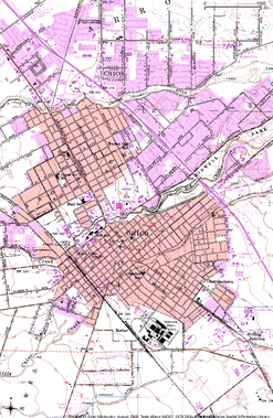
 Map of Chico urban area, 1978, on USGS 7.5x7.5 minute topographic map. Data from the California Spatial Information Library. The following pages have editor created maps of Chico and surrounding areas. Maps of Chico and surroundings can be created using a variety of resources and tools.
If you adapt a previously made map, please say so and cite the source. Always cite data sources that appear on maps. Finally, use "STANDD" if at all possible. That is, put Scale, Title, Author, North Arrow, Date, and Datum on maps to help make them more readable and understandable from an outside context. If you're a pro at categorizing maps in a reasonable way, please, by all means, reorganize this jumbled up page. If you are looking for the most detailed map of Chico, with parcels, zoning, etcetera you will want to look at the City of Chico GIS Web (link may not work for Firefox). You may suggest new maps at the bottom of this page.
Available Maps
Bicycle Rides
See also Bicycle Rides. If you'd like to see a bicycle route mapped on Chico Wiki, please describe it on on that page.
Aerial or Satellite
- Bidwell Park - overview map with Bidwell Park boundaries
- Chico - view of Chico (1998)
- Dayton - view of Dayton (1998)
- Fred Meyer - view what used to exist before Lowes (1998)
- Missile Silos - overview of Chico's nearby missile silos (1998)
- North Valley Plaza - see when it was still an indoor mall (1998)
- The Wedge - find out where this cultural geographic feature is in Chico
Topographic
- Chico - 7.5x7.5 minute USGS topographic map for most of Chico in 1978
- Swimming holes and parking areas in Upper Bidwell Park (from Bear Hole to Brown's Hole)
Wild Fires
See also Wild Fires.
- Butte Lightning Complex - early fire perimeter
- Craig Fire - final fire perimeter
- Humboldt Fire - final fire perimeter
Political
- Surrounding Communities - locations of cities around Chico
- Butte County - where Butte County is in California and its urban areas.
- Butte County Board of Supervisors - Butte County Supervisor District map (adapted from original map by Butte County)
- Geography and Geocaches - Regions of Chico (North, South, etc.) for town orientation
- Chico Unified School District boundaries and nearby districts
Other
- Geology - basic map of Butte County lithology
- Parking Downtown - locations of parking lots in downtown Chico
- Mendocino National Forest - relative location and extent
Needed Maps
If you're familiar with QGIS (or want to be!) or other GIS software, the following are examples of maps that the wiki needs. Remember to cite all data resources.
- Density of Geocaches
- Boundaries of the Greenline
- Plotted school locations
- Bidwell Park hiking maps
Looks like somebody already tracked most of the trails for the Open Street Map project. Lacks the north rim but I think that can be digitized off of USGS topographic maps. Exciting stuff. —RyanMikulovsky
- Location of Taco Trucks in Chico. Really!
- Bicycling and walking paths (popular and not so popular)
- Greenways
- State Parks near Chico
- Page Density Map — show where most pages are in Chico to give people an idea if their part of town is underrepresented etc.
Do you have a suggestion for a map? Or other comments?


