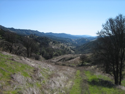
 Hiking trail with Blue Ridge in the background to the left.
Overview
Blue Ridge and Rocky Ridge form a 30 mile long divide in the Northern Coast Range west of Davis in Napa County. Their southern terminus is located at Monticello Dam, just north of Cold Canyon. Combined, they extend in a north-north-west direction for 30 miles until the northern terminus of Blue Ridge at the mouth of Cache Creek, north-west of the town of Rumsey. Lake Berryessa and the Putah Creek drainage are located to their west. Capay Valley and the Cache Creek drainage are located to their east.
Geology
Mostly unknown to me. I imagine Blue Ridge and Rocky Ridge are part of the same geological formation. The two ridges appear to actually be one ridge broken in two pieces by a saddle cut by Green Canyon/Creek. I'd like to hear about it from a real geologist.
Access
Public access to this area is extremely limited. There are NO trailheads and NO public hiking lands anywhere on Rocky Ridge. Blue Ridge can be accessed only at the north end via Blue Ridge Trail, Valley Vista Trail, Long Canyon Trail & nearby areas in Knoxville Wildlife Area.
Accessing the North-East Side
Highway 16 runs up the Capay Valley to the east of Blue Ridge. Trailheads for accessing the north-east side of Blue Ridge are near Camp Haswell and at Rayhouse Road.
Accessing the North-West Side
From Davis go west on Covell Boulevard or Russell Boulevard. Covell becomes Highway 128 and merges with Russell. Highway 128 passes below the southern terminus of Rocky Ridge at Monticello Dam. After passing the Dam continue on 128 to Berryessa-Knoxville Road. Make a right on Berryessa-Knoxville and follow it along the west shore of Lake Berryessa. After rounding the north side of Lake Berryessa, Berryessa-Knoxville Road continues north to the Long Canyon trailhead.
Activities
Blue Ridge and Rocky Ridge are some of the closest major geological features to Davis which provide the opportunity for outdoor activities. If it is hot in Davis, it will be hot on Blue and Rocky Ridges. For this reason, recreating in this areas is best in the late fall, winter, or early spring.
Bicycling
Camping
While there are no public campgrounds on either ridge, much of the land is public, and is legal to camp on. If camping in this area plan on providing everything for yourself (e.g. water, food, toilet).
Climbing
Blue Ridge and Rocky Ridge have many rock outcroppings at the top. These outcroppings may be good spots for rock climbing.
Four Wheel Driving
USGS topographical maps show many four wheel drive trails traversing both sides of Blue Ridge and Rocky Ridge. Some of these trails may be on private land or may be inaccessible for other reasons.
Hiking and Backpacking
 Hiking up Long Canyon toward Blue Ridge in February.
Blue Ridge and Rocky Ridge provide a great opportunity for hiking and backpacking close to Davis. Hiking destinations and descriptions on Blue Ridge can be found at Hiking Trails Napa wiki and at Yolo Hiker.
2011-05-30 08:09:54 I'll look into the geology of the ridges. I suspect most of it is part of the Great Valley Sequence (Cretaceous). A cursory look at the CGS Geologic Map of California show lower and upper great valley sequence in the area. I will integrate into the main article once I find larger scale maps with better map units. —RyanMikulovsky


Comments:
You must be logged in to comment on this page. Please log in.