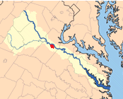
 Rappahannock - Wikimedia The Rappahannock River is a natural boundary to the north and east of the City of Fredericksburg and provides an opportunity for dinner cruises in nice weather. The river is also a local fishing destination.
Local Attractions
About the River
The Rappahannock begins in the Blue Ridge Mountains in the west, crosses the Piedmont and is joined by the Rapidian; on the north side of Fredericksburg at the natural "fall line" it enters the Tidewater region and runs to the Chesapeake Bay, south of the Potomac River. In its upper reaches it is a clear, running river with Class I to III rapids supporting canoeing and kayaking. Below Fredericksburg the river is a slow, meandering and brackish tidewater river.
"The Rappahannock River's character changes abruptly in Fredericksburg at the fall line (the limit of tidal influence). Above the fall line, the river is usually clear, swift, and dominant substrates are bedrock, boulder and cobble providing perfect habitat for smallmouth bass and related species. However, below Route 1 the river is tidal, and the substrate is finer, dominated by sand; and the water is frequently murky. Species composition shifts with habitat, and largemouth bass, catfish and anadromous species are more common in and below Fredericksburg. Boaters and anglers can now navigate from upstream access points such as Motts Landing across the old Embrey Dam site and into the tidal waters adjacent to Fredericksburg." 1
The fall line separates the Piedmont Region from the Tidewater Region and runs from a point on the Occoquan River at Occoquan, VA, through the falls north of Fredericksburg on the Rappahannock to a fall line on the James River at Richmond.
Photos and Photo Links
-
River on SimplyFredericsburg.com
Notes and References
-
Rappahannock River Upper on VA Dept of Fisheries, includes maps of access points and fishing info.


