Oileán Bhríde or Rabbit Island is a townland of 8 hectares or 21 acres and is located just off the Trá an Oileáin. In the early part of the 20th century, 8 individual fields were mapped in this townland.
It is in the Electoral Division of Myross, in Civil Parish of Myross and the Roman Catholic Parish of Castlehaven and Myross.
Oileán Bhríde is not surrounded by any townlands.
OpenStreetmap contributors, with input from the Castlehaven & Myross History Society, have created a detailed townland map including all its minor placenames. Zoom in for further detail.
Etymology
Oileán Bhríde is interpreted by Bruno O'Donoghue as (the) Island of Bríd or Bridget. The 1607 grant to O'Donovan lists it as "The Island of Briddie called Sconice" and the Logainm entry for Oileán Bhríde shows various English writers giving it as Squince Island and even Quince Island. Squince is known as Scaoinse in Irish (pronounced Scuinse) and locals say that it can be interpreted as a place where you have a draught of wind or water.
The English name of Rabbit Island first shows up in 1842 and there is even an Irish version of this name Innse na gCoinín given around this time. Oileán Bhríde is one of the few townlands in the parish that does not have an anglicised version but instead has an actual English placename that has a different etymology.
History
Inhabitants: The island was inhabited until 1932. The last family to live there were O'Driscolls. They would row across to Trá an Oileáin and walk to school on the mainland and back again in the evening. A great fire, exacerbated by the presence of tarred ropes and fish oils, which swept through the outhouses and homestead forced them to leave the island and settle on the mainland in April 1932.
Gaeilge: Tadhg Ó Drisceoil from Oileán Bríde was quite possibly the last native Irish speaker to live in the parish of Castlehaven and Myross. Fortunately, a recording of Tadhg speaking in his native language was made in the 1970s . It constitutes an invaluable record of the local dialect.
👂 You can listen to Tadhg by clicking here:

 Ruins of dwelling house on Rabbit Island
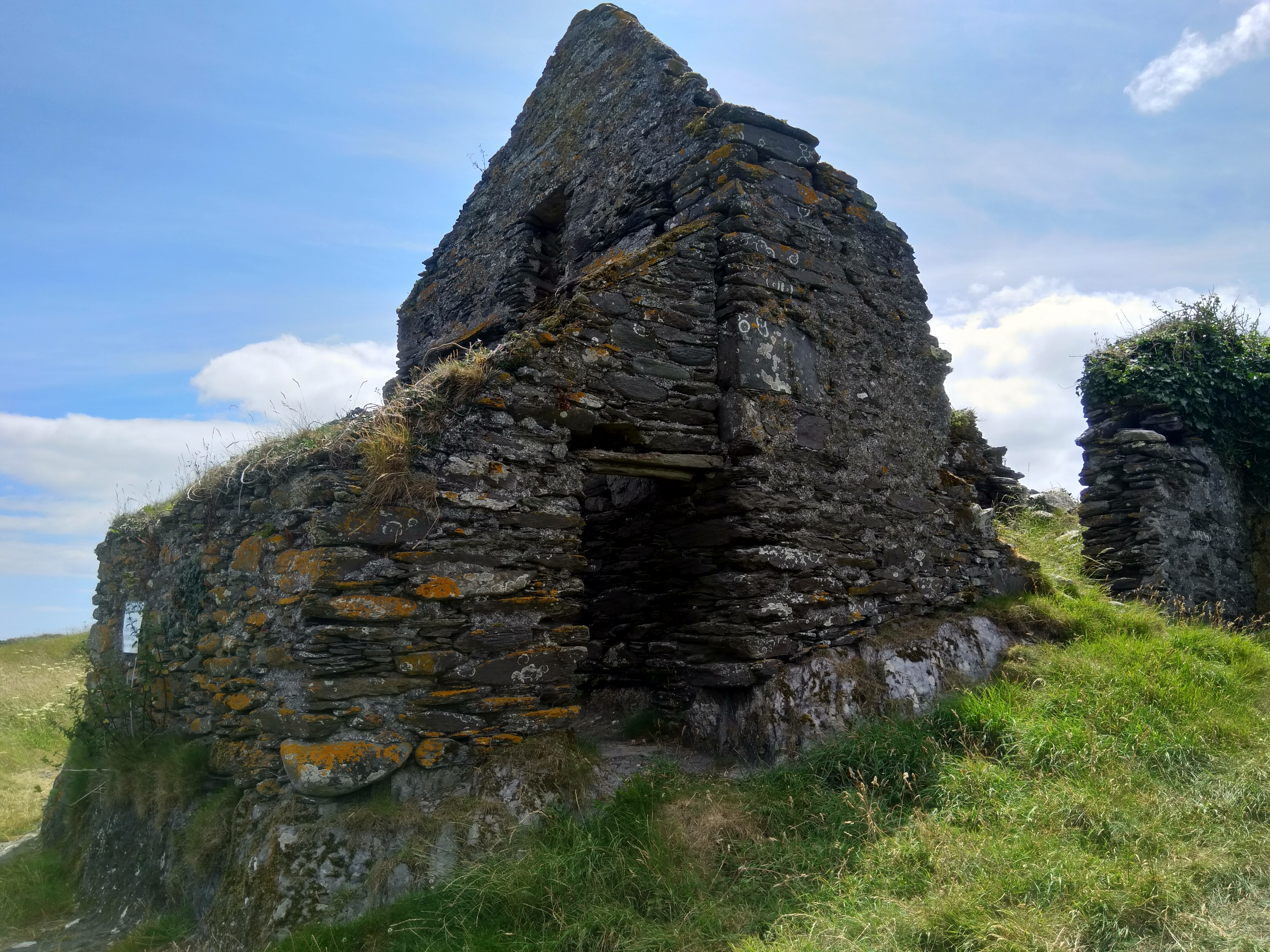 Ruin of dwelling house on Rabbit Island
Housing
As part of Griffiths Valuation in 1852, a survey of house quality was carried out to calculate what rates were due by each household. These were issued in the form of house books and a guide on how to interpret these can be seen here. These show that there were only two occupied houses on the island at that time and they were both class 3C which means that that were old (more than 25 years) and out of repair. They were both 6 foot tall which indicates that they are single storey at this time.
By the 1901 census there are now 3 occupied houses and all have walls of stone, brick or concrete. Two have a roof of slate, iron or tiles while the other is still thatched. All three houses have two, three or four rooms with two having just two windows in front (which indicate that they are probably still single storey at this time) while the other has five windows in front.
When we advance to the 1911 census there are only two occupied houses again and, not surprisingly, both still have walls of stone, brick or concrete. One now has a roof of slate, iron or tiles while the other is still thatched. Both have two, three or four rooms with just two windows in front (which indicate that they are probably still single storey at this time)
Places of Interest
Stáca: The distinctive rock, at the eastern end of Rabbit Island is known as the Stáca. It was probably originally known as An Stáca na mBeann - beann or ben meaning peak. It was wrongly mapped as the Stack of Beans on old maps. The small islands between Rabbit Island and the Staca are known as Oileán Meánach (middle island) and Oileán a' Staca (staca island)

Holy Well: There was a holy well on the island. It was dedicated to St. Bridget and locals would gather there on the eve of St. Bridget for devotions. It was said that this practice stopped after some pilgrims drowned on the way home from the island.
Interesting Placenames
There are a number of rocks around this island which include Carrigín Thoir (little rock to the north), An Charraig Fhada (long rock), Carraig Fhada an Dúna (long rock at the fort), Óileáiníní Páirc an Dúna (small islands at the field of the fort), Oiléaníni Thrá Tobar Nua ((small islands at the strand of the new well) and Carraig an Anama.
There are a number of beaches on this island which are named as follows: Trá an Tobair (strand of the well), Trá an Tí (strand at the house), Trá an Dúna (strand of the fort), Trá an Duine Báidhte, Trá na n-Iomairí.
There is a cove known as Cuas na Geire Thuaidh and another known as Cuas na Geire Theas
There is a location on the island known as Pollín na bhFranncach (small hole of the French men) which probably relates to smuggling to and from the island from France
There is another location known as Oileáinín na Geámsana. This is not an island but a place where the islanders stored a large and rough breed of potatoes called Geámsana.
There is a peak on the island known as Péicin Thalamh na Gainmhe
Field names on this island have been captured as follows: Mullach, Páircín Risteáird (Richard's small field), Páirc an Tighe (house field), Talamh na Gainimhe, An Pháirc Mhór (the big field), Cúilín na Páirce Móire (back of the big field), An Dún (fort)
If you want to see the actual locations of any of these, go to detailed townland map on Open Street Maps. If you know any other field names or place names in this townland (or if you need to correct any or give further background information), please contact us at [email protected]
Folklore
St Brigid: : Local legend states that Tobar Bhríghide (Brigid's well) was originally located on the island.
When St Brigid was touring Ireland, she arrived at the Banks of the Bride - a river near Cill Cré Abbey. There she met a very Holy man who told her that he was going to live the life of a hermit on a lonely island close to Glandore Harbour. She accompanied him to this Island. When they arrived in Myross, they were taken on a boat to this island.
They travelled round this island. The man felt sad at the absence of fresh water, but St Brigid told him to dig a small hole in the ground and she made the sign of the Cross over it three times and a spring burst forth since known as Tobar Bhríghide (St BrIgid's Well) and the Island was called Oileán Brighde. At a later date the island fell into possession of one of Cromwell's Soldiers who disliked the name of the Saint on the island and changed it to its present name - Rabbit Island. This account appears in the schools' collection: https://www.duchas.ie/en/cbes/4921624/4886017
Mrs Nellie O'Driscoll, who was born on the island, recounted this story to Therese O'Mahony of Céim Hill. "When I was a child growing up on Oiléan Bhríde, my mother took me on a walk through the fields. On arriving at a special field she stood still and said, " Do you see that field which contains many water pools and part of which has a very boggy soil?" "Yes" I replied. "It was in that very field that St Brigid's Well was originally situated. When the drowning of the pilgrims took place, the well was moved and it appeared in a field on the farm of the Hegarty family of Ardra on the mainland. In that time this incident was considered to be a miracle. It was spoken about far and wide." "Then my mother did not utter another word" exclaimed Mrs O'Driscoll.
Horse Cure: It was said that there was a "wonderful sort of herbage on the island that recovers diseased horses to admiration"
Myross Poem: According to Lankford an old poem about Myross refers to the following:
Baile na Tóna agus paróiste Mhiodhruis
Meall Uí Chorráin agus dá Rinn theas
An t-Oileán Árd agus an t-Oileán Íseal
Oileán Molua agus Oileán Brighde
(Ballinatona and the parish of Myross, Maulicarrane and the two South Reens, High Island and Low Island, Horse Island and Rabbit Island).
Smuggling: There is cave on the island called Pollín na bhFranncach, which can be interpreted as The Hole of the Frenchmen. Back in the past, some of the residents were smugglers and they would travel back and forth to France. The women would travel back a few sizes bigger as they would smuggle a number of dresses on their person. French crew members would travel back with them so this might be the reason for the name.
War of Independence: According to an article in the Castlehaven Journal, Pat O'Driscoll was entrusted with making preparation for a cargo of rifles and ammunition from Italy during the War of Independence. Liam Deasy and Sean Lehane went out in a motor boat about 30th January 1920 and looked for a likely place to land the arms. They decided that Rabbit Island formed good cover for a ship coming into Myross as once inside the island the ship would be safe from the searchlight of the British Naval sloop which regularly policed Glandore Harbour and the neighbouring inlets. There was a good depth of water between the island and the mainland as the channel was hundreds of yards wide. They selected three different points so that the work of bringing arms ashore could be carried on simultaneously and would be thus be three times as fast.
Families and Notable Residents
The Tithe Applotment books of 1829 list the following family names: No official records exist but it is said that Dinneen, Murray, Nagle and probably Driscoll families lived there at this time.
Griffiths Valuation of 1853 lists the following family names: Dinneen and Driscoll. Wm Dinneen and Flor Driscoll rent land from Whelply on Rabbit Island no. 3 and no.4 (East) and have houses and land on Rabbit Island no.5
The Census of Ireland of 1901 lists the following family names: Driscoll, Driscoll, Dineen (with Keohane - servant)
The Census of Ireland of 1911 lists the following family names: Driscoll, Driscoll (with McCarthy - daughter/ housekeeper)
Note: the term 'with' refers to a person or persons of a different family name staying in the house. This may have been an in-law or other relative, a guest, or a farm labourer/housekeeper or domestic servant.
Demographics and Landholding
| *Occupiers | Population | Change | Link to record | ||
| 1825 | Tithe Applotment | 2 | 16+ | ||
| 1841 | Census of Ireland | 2 | 17 | ||
| 1851 | Census of Ireland | 2 | 21 | ||
| 1853 | Griffith's Valuation |
2 |
20 est | 1853 | |
| 1861 | Census of Ireland | 2 | 19 | ||
| 1871 |
Census of Ireland |
3 | 15 | ||
| 1881 | Census of Ireland | 3 | 13 | ||
| 1891 | Census of Ireland | 3 (Incl 1 unoccupied) | 16 | ||
| 1901 | Census of Ireland | 3 | 19 | 1901 | |
| 1911 | Census of Ireland | 2 | 13 | 1911 |
*Occupiers generally equate to households having a house and land but may also include households having houses but no land.
Between 1656 and 1658 the Down Survey mapped all areas of the country to track ownership of land after much had been granted to followers of Cromwell after the war of the 1650's. The most prominent proprietors (titulados) of this townland at that time was Hugh McKnogher (possibly McConnor). This townland was called Quince Island at that time.
The proprietor of this townland in 1841 was Richard Beecher of Hollybrook, Skibbereen and his agent was Thomas Hungerford of Skibbereen. It was let to John Limrick of Ardmanna, Schull and sublet to two tenants. It was not subject to a County Cess or a tithe. At that time there were 7 males and 10 females living on Rabbit Island and the prevailing names were Dineen and Driscoll.
No description of soil quality in 1841 was given.
Images
 Strand looking west to Squince
 Strand looking east towards Carrigillihy
 Tráigh na nIomairí on the south side of the island clearly showing the ridges (iomairí) that give the strand its name
 Looking north towards the houses and the mainland beyond

 Oileán Bhríde ó thuaidh ag deireadh an lae
<div>
Further Reading
-
Parish Histories and Placenames of West Cork - Bruno O'Donoghue
-
Placenames Database of Ireland Logainm.ie entry for statutory version in Irish and English
- A Collection Of Placenames From Cork County, Barony Of West Carbery (East Div.),Volume 6 - Dr Éamon Lankford
- Duchas.ie Collection - https://www.duchas.ie/en/cbes/4921624/4886017
- Castlehaven & Myross History Society Journal Vol. 1 - 2020 - The Failed Myross Gun-Running Project 1920-1921 (Denis Shanahan) Pgs 67-70
- Castlehaven & Myross History Society Journal Vol. 2 - 2021
- Castlehaven & Myross History Society Journal Vol. 3 - 2022
- Parish Histories and Place Names of West Cork - Bruno O'Donoghue
- See townlands.ie for information on this townland
- Growing Up on Céim Hill - Therese O'Mahony
Links
Go to Homepage
Go to list of Townlands
Go to list of Irish words used locally
Go to local Flora and Fauna
</div>

