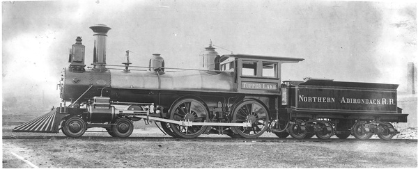
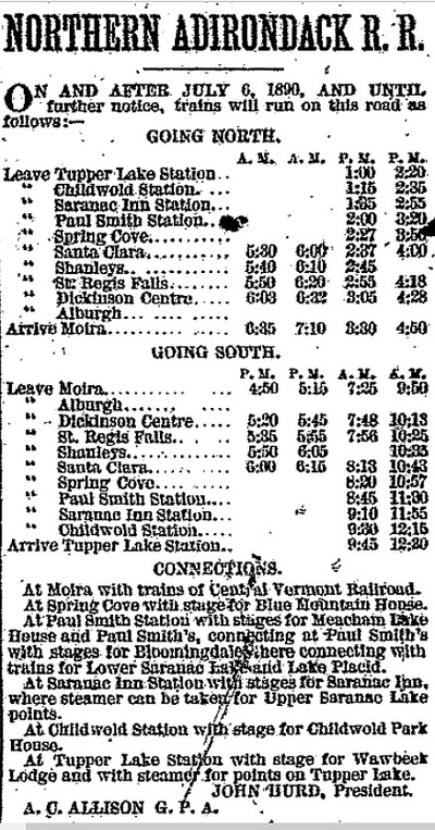
 Northern Adirondack Railroad - "Tupper Lake"
Source: National Park ServiceThe Northern Adirondack Railroad was built by John Hurd south from Moira to Tupper Lake between 1883 and 1890, passing the logging operation at Brandon, then known as Paul Smith's Station in 1888 (Brandon became part of William G. Rockefeller's Bay Pond preserve in 1898).
Hurd went bankrupt in 1895, and the company was reorganized as the New York and Ottawa Railway, and soon after was absorbed by the New York Central as the Ottawah Division.
 Malone Palladium, May 15, 1890Source: Barbara McMartin, The Privately Owned Adirondacks, Lake View Press, Canada Lake, NY, 2004, pp. 103, 105
Tupper Lake Free Press, May 5, 1982
…Started in 1882 to link St. Regis Falls with Moira, the line was gradually extended by Hurd to reach now-gone and largely forgotten sawmill settlements at Meno, Brandon, Bay Pond, Buck Mountain, Derrick, and reached the shores of Raquette Pond here in 1890. Hurd's "Northern Adirondack" line and the Big Mill which he erected touched off the settlement of Tupper Lake village, which fared better than its founder. The precariously-financed railroad went into the hands of receivers in 1895 and was taken over by New York Central in 1906 via a bondholders' foreclosure sale. While large-scale lumbering lasted it "made ends meet", but the lean times of the 1930s sealed its fate. The Free Press reported that "tomorrow morning H.B. Smith, supervisor of track, and Vernon Proper, assistant supervisor, both of Faust, with a crew of 30 men, will start at Santa Clara and work back toward Tupper Lake, pulling rails and ties and loading them on gondolas for salvage…
Plattsburgh Sentinel, June 18, 1886
FRANKLIN’S NEW LUMBER REGION
The Northern Adirondack Railroad; Moira to Buck Mountain; One Man Power, Lumber Camps, Sawmills and Tanneries.
(Correspondence of the Canton Advertiser).
 Three months later, Childwold and Saranac Inn stations were added.
Malone Palladium, August 28, 1890The new railroad, known as the “Northern Adirondack,” begins at the Moira depot, on the Ogdensburgh and Lake Champlain railroad, and runs southerly up and around hills, to an incipient lumber camp now known as Buck Mountain, where the forest is being cleared away and a sawmill is about to be erected. As yet, there is scarcely a place where the weary traveler can lay his head or find a meal, except in some little camp or hut of the most primitive construction. Buck Mountain, sometimes called “Labourf’s” is eight miles south of the farthest point to which the railroad is now graded.
The first station out from Moira is Alburgh, distance, three miles. This is a mere hamlet, in the midst of a good farming country. Dickinson Centre, a village of some importance, population about 250, is eight miles from Moira. Four miles further south we come to St. Regis Falls, a growing place of about 600 inhabitants, with large lumber mills, a very extensive tannery, two hotels, several boarding houses, restaurants, etc. The surrounding country is hilly and rocky, and poorly adapted to agricultural purposes. The grade of the N. A. R. R. to this point is such that the brakes have to be applied to the cars nearly all the way on the downward trip. From here the railroad ascends through what may properly be called a slash, the best of the timber having been taken off years ago, so that now the country on either side of the road, until “Santa Clare” [sic] is reached, presents a dismal array of old trees, lying and standing, among rocks and sandbanks, on hills and in swamps, relieved by a small river, which is filled with millions of feet of spruce logs.
Santa Clare, which is but a lumber camp, is, like the railroad, owned by one firm, and no citizen or foreigner can purchase land there on which to erect a dwelling or place of business. The eating house in the railroad station and the store, are both controlled by the same firm. So are all the mills, and the houses are all built and rented by them to their employees. The soil is sandy and hilly, and well calculated for a desert when the scattering timber is cut off. This camp is 18 miles from Moira.
Spring Cove, the next place on the line of the projected road—as yet only a place in name and on paper—is located in about the same kind of timber and soil as Santa Clare. The next place on the line is called Madawaska, not yet built, 29 1/2 miles from Moira, and then Paul Smith's station, where the railroad is expected to reach at some future time, but which now only exists in the imagination as a railroad terminus. This prospective "station" is some miles from the famous summer resort so widely known as “Paul Smith's.”
This railroad has a high grade all the way. It rises 1,100 feet in going from Moira to Santa Clare, distance of 18 miles. Nearly the entire region is ill fitted for agricultural purposes, owing to the barrenness of soil and the high altitude. The places that spring up while lumbering lasts will decline in the near future, like other places where the timber is exhausted. As the company can purchase no more forest lands from the State, their operations are limited to a few years.
Malone Palladium, May 19, 1887
A circular just issued by the Northern Adirondack R. R. announces that arrangements have been made, under which, during the present summer, a sleeping car for Paul Smith's Station will leave New York daily at 6:30 P. M., coming by way of Utica and Norwood to Moira, and arriving at destination at 8:15 the next morning, which will enable tourists to breakfast at Paul Smith's by 9:30, or only 15 hours from New York. A sleeper for the same point, to be hauled over the Central Vermont R. R., will also leave New York daily at 7:00 P. M., arriving at Paul Smith's Station at 11 o'clock the next morning. Returning, trains will leave Paul Smith's Station daily at about two o'clock P. M., making close connection at Moira with trains going east and west. The wagon road from Paul Smith's Station to Paul Smith's [presumably part of the Blue Mountain Road and Keese Mills Road], the condition of which became horrible last year, is being thoroughly repaired, and a new road is being built from Paul Smith's to Saranac Inn (formerly the Prospect House) which will reduce the distance between them from 17 miles to eight.1 Stages will also be run from Paul Smith's Station to “Wardner's” at Rainbow Lake and to Lake Meacham, though Malone still remains the popular point of entrance to the latter resort. The reason for so complete arrangements having been made for travel into the Adirondacks by this route is the desire of the Northern Adirondack management not to permit tourists to be attracted from it by the Chateaugay R. R. There will be sharp rivalry between these two roads, and each will offer the greatest conveniences and rapidity of transit possible to secure summer patronage.
Franklin Gazette, April 12, 1889
The Northern Adirondack Railroad Company have commenced the. work of erecting a bridge at Paul Smith's station, and it is said will proceed at once to the work of extending their line to Raquette Pond, near the settlement of Long Neagh, some twenty miles south-west of Paul Smith's Station.
Malone Palladium, April 18, 1889
Men are already in the woods getting out ties, and as soon as spring fairly opens the work of grading mil be begun for the extension of the Northern Adirondack R.R. from Paul Smith's Station to Tapper's Lake, a distance of 23 miles. The extension will open a tract rich in timber and also add very much to the roads importance as a route for pleasure travel to and from the Adirondacks.
Note:
- Via modern route 30 it is 12 miles from Paul Smiths to Saranac Inn, so it is not clear what the 17 mile route was. Interestingly, though, if you shorten the Route 30 trip by going to the west of Lake Clear, using the existing road to the Lake Clear Girl Scout Camp and trails from there to Conely Road, the trip is just under ten miles. A direct route from Upper St. Regis to Route 30 opposite Forest Home Road would make the route 8.5 miles. But the 1905 USGS map shows no such roads.


