The "Marquette Gravesite Locator App" is a challenge for the 2014 Code Michigan competition.
http://www.michigan.gov/codemichigan/0,5752,7-331-69195---,00.html
Problem Statement: The phones at Marquette City Hall are ringing and Visitors to Park Cemetery want to know where Uncle Jerry is buried. Park Cemetery's 113 acres can make it difficult to find deceased family members.
Challenge: Develop an application to aide in the location of grave sites within Marquette's historic Park Cemetery.
Incentive: One-week internship (unpaid) in the office of 109th District State Representative John Kivela. This is your opportunity to work one-on-one with a State Representative to collaborate on ideas! OR Participate in a five-week mentoring course through the use of Marquette’s newly established SmartZone business accelerator. The Smart Start mentoring course takes an idea and it’s team and is coached through a process to determine whether or not it will be a viable business through customer discovery, market analysis and business development. The Smart Start program is valued at $500. Opportunities for business development beyond the Smart Start program are limitless.
Other interested parties
The Marquette Regional History Center hosts cemetery tours. [TV6 story]
Data
The data set is here: https://data.michigan.gov/dataset/Park-Cemetery-Alphabetical-Log/fzgb-esp8
A JSON formatted dump of the data is here: https://data.michigan.gov/api/views/fzgb-esp8/rows.json?accessType=DOWNLOAD
Map
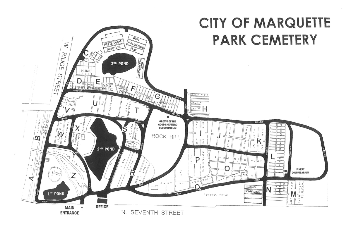
The PDF map of the cemetery: http://www.mqtcty.org/Maps/ParkCemetery.pdf
PNG version:
Detail maps
The plat on the map marked "JENNY'S PLAT" is in the dataset in two parts, Jenney E and Jenney W. Jenney E corresponds to the section A on the map, and Jenney W is section B.
A plausible approach to this effort would provide a name list in plat order for each of those sections.
Issues
Several minor errors in the cemetery transcription have been noted by examination of the data. The oldest record in the system for William H. McLaughlin claims a date of 1830, but a close examination of the grave marker found on Find-A-Grave suggests that it could really be 1880 instead. The key is that the gravestone image found on Find-A-Grave says that he drowned off the Tug Dudley; that tug was active on Lake Superior after 1865.
Field 7, "plat", is coded in the database as a "location", which wants to be parsed as a latitude and longitude. What's really in the data is a "plat name", that is to say a named section of the cemetery. This field is completely omitted in the CSV version of the data dump, and in the JSON version it's coded as something like this (extracted using the "jq" tool):
% jq "[.data[3][7,11,12]]" < Park_Cemetery_Alphabetical_Log.json  | more
[
  "{\n  \"invalidCells\" : {\n    \"21137089\" : \"Potters Field\"\n  }\n}",
  "Anderson, Andrew",
  "1892-06-02T00:00:00"
]


