 Dimond District in the evening. (by mk30)The Dimond District is a general area that consists of Upper Dimond, Lower Dimond, School, and ??? Though to someone who lives in neither Lower Dimond or School, there's definitely a different feel going through each because of the freeway dividing them. #FWIW. [I lived there before the freeway came through, at that time in my mind the Dimond District went from Park Blvd to the east, to Lincoln Blvd/Boston Ave to the west, the Monclair Driving Range/Dimond Canyon to the north, to School St. in the south. In the 50s and 60s Dimond Park was the central hangout for many of the kids from what the are now calling upper and lower Dimond districts, we knew Dimond Canyon better than our own back yards.] [The heart of the District was the intersection of MacArthur Blvd and Fruitvale Ave. What is Sausal (and has been since the 1800s) Creek was known to the locals in the area as Dimond Creek. le]
The Dimond Neighborhood Association uses the following map which goes well below 580 and East of Fruitvale. In the Real Estate world, Lower Dimond is the narrow swath above 580 and below MacArthur that extends East to just past Laurel Ave (it follows Peralta Creek). On the East side of Lincoln, the neighborhoods below MacArthur feel very similar.
A flowery description of the Dimond from 1896 titled "Dimond the Beautiful" says "Fruitvale is for beauty one of the notable avenues in this country." 2
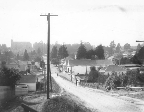
[Found two great old Dimond District photos (see below) from shortly after the turn of the last century. Not sure which of the Dimond District neighborhood entries/pages each of them belongs, but will be happy to move them if some handy map expert points out the correct locale.][this is an ongoing issue that i have never felt like resolving :) one day! i don't think your sources made it over though, just the footnote. -gk] [ Just an educated guess, present day foliage changes the skyline but the picture on the left seems to be where present day Lincoln Ave. intersects MacArthur Blvd [Hopkins]. The street at the bottom of the hill on the left, would be Champion St. ] [Hopkins/MacArthur continued up to the hill in the distance but veers left (the hill is Excelsior Ave) around to the front of the tall church looking building, which is (I believe) present day Altenheim Senior Housing as it was in the 1950s to present day. At the very bottom of Hopkins just past Champion St would have been the intersection of then Fruit-vale and Hopkins, the main shopping area for the Dimond District. le]
 Tepper's Garden, a popular resort along Hopkins Street (now MacArthur Boulevard) in the Dimond District of Oakland, California (1909) 1
  Dimond looking west on Hopkins Street (now MacArthur Boulevard) into the Dimond commercial district, with the Altenheim in the distance (1910) 1
Additional Links
- 1. Oakland Public Library, Oakland History Room and Maps Division
- 2. Dimond the Beautiful San Francisco Call April 13, 1896
- Memories Linger for Dimond District Pioneers, The Knave in Oakland Tribune, November 8, 1970, p. 121 and 124
Stuff on the wiki tagged Dimond


