

Northernmost
A point on the access road behind Summit Dr., adjacent to Tilden Regional Park. 1
 View south from northernmost point
Westernmost
– Absolute (W1): A point in the Bay outside Emeryville
– Publicly accessible over water (W2): A point on the Bay Bridge two miles west of the Toll Plaza
– Land (W3a): Western tip of Ben E. Nutter Terminal, tw. berths 37 & 38, Oakland Outer Harbor
– Publicly accessible on land (W3b): Western tip of Port View Park
Southernmost
– Absolute (S1): A point in the Bay, west of Hayward Regional Shoreline
– Land (S2a): Tip below Runway 30; (S2b) back left of a plane (window seat “A”) about to take off
– In a building (S3a): Far left end of Terminal 2, Gate 32
– Publicly accessible on foot (S3b): Along far end of Edward White Way, at the security gate
Easternmost
A point about 110 feet east of the Goldenrod Trail in Anthony Chabot Regional Park, about 1/3rd mile south of the conjunction with Columbine Trail
Center
Two lines connecting the absolute extremities intersect at approximately Foothill Blvd. x 21st Ave.

Two lines connecting the land extremities intersect at approximately Fruitvale x 880
Highest
Chaparral Peak (1760+ ft., at the bend in the county boundary west of the "C" in the "CO" in "CONTRA COSTA CO"), 37.878428, -122.223405. 2
 Portion of 1947 topo map.
Lowest
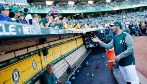
Probably the dugouts at the Coliseum (field is -21 ft, so about -22 ft)
Links and References
- "North point," Oakland Geology blog 23 Aug 2011
- "The highest point in Oakland," Oakland Geology blog 25 Sep 2017

