 Bilton Road parade, built in the 1950s. Photo by Ian Robinson in July 2007. Bilton Road runs downhill from the Gyratory System to the traffic lights at the Buchanan Road junction, where there is a small parade of shops. The Sow Brook runs diagonally underneath this junction, though a large underground pipeway installed in 2008. The road then runs relatively level until it meets the traffic lights at May Lane and Lytham Road, where there are a Blockbuster store and a Lidl Store on opposing corners of the junction. It then heads uphill to Bilton Green, where it meets Main Street and Bawnmore Road at yet another set of the traffic lights.
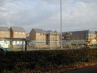
 New development on Bilton Road, photo by Annette in November 2007 In 2007 a new development was begun on the site of the allotments which used to be next to Bernhards Garden Centre. This grew quickly until the housing price crash in 2008, when building slowed greatly.
 View along Bilton Road in 1930. (Copyright) This photo looks as though it was taken at the Rugby end of Bilton Road, just before the road bears to the right and starts downhill.
 Oakfield Preparatory School, Bilton Road, in 1900 - 1909 (c.) (Copyright) Oakfield Park now houses the Social Services offices. This view is possibly taken from what is now Oakfield Recreation Ground.


