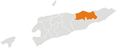
Baucau District
Baucau is located on the eastern part of the country, around 122 km of Dili. It is the second biggest city of the country with a population of 111.694 inhabitants (Census 2010) and an area of 1.494 km². The capital of the district is also named Baucau. During the Portuguese colonization, it was called Vila Salazar, after the Portuguese dictator. Baucau District comprises the subdistricts of Baguia, Baucau, Fatu Maca, Laga, Quelicai, Vemasse and Venilale (formely known as Vila Viçosa). Baucau has the country’s biggest international airport (IATA code: NCH) at 6 km from the city, which is now inoperative for commercial flights. The tunnels in the subdistrict of Venilale (ex-Vila Viçosa) are a legacy of the Japanese occupation during the Second World War. The main economic activity of Baucau is agriculture (corn, rice, peanut, coconut and horticultural crops). With the gradual improvement of the transport system and the provision of electric power, the private sector and the small and medium enterprises are now registering a progressive development. Baucau offers a wide coastline with attractive beaches, ideal for swimming and other water sports. In addition to the official languages of the country (Tetun and Portuguese), the majority of the population speaks Macassai.


