| Location |
| 223 Teton Place |
| Size |
| 3.794 acres |
| Phone |
| (530) 661-2000 |
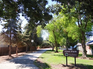
 The east entrance to Cline Park from North Cottonwood Street, in the center of Cline-Schneider Alley. This entrance directly faces an entrance to Joseph Schneider Park. Photo by queerbychoice.Wayne Cline Park (a.k.a. Cline Park) is a sprawling, irregularly shaped park located between North Ashley Avenue, West Kentucky Avenue, North Cottonwood Street, and West Woodland Avenue. It is a walking-oriented park, comprised mostly of alleys between roads; one of the alleys connects (across North Cottonwood Street) to nearby Joseph Schneider Park. The most direct access to the widest part of Wayne Cline Park is from Teton Place or Rainier Place.
 The north entrance to North Cline Alley from Kentucky Avenue. Photo by queerbychoice.
None of the alleys in Cline Park has any official name, but for reference on this wiki, the alleys are described as follows:
- Cline-Schneider Alley is the narrowed area of Cline and Schneider Parks that meets in the middle, intersecting with North Cottonwood Street. On the west side of North Cottonwood Street, this alley runs between Teton Place and Glacier Place and is part of Cline Park. On the east side of North Cottonwood Street, this alley runs between Schuler Ranch Drive and Glacier Street and is part of Schneider Park. There are signs on North Cottonwood Street for both parks.
- North Cline Alley is the unnamed footpath that runs from West Kentucky Avenue (on the opposite side of that street from Jeff Roddy Memorial Park) to the north end of the widest part of Cline Park, between Yosemite Place and Carlsbad Place (both of which have access to the alley). It has a sign for Cline Park at its north end, on West Kentucky Avenue, because it is part of Cline Park.
- South Cline Alley is the unnamed footpath that runs from West Woodland Avenue to the south end of the widest part of Cline Park between Mount Hood Court and Glacier Place (both of which have access to the footpath). It has a sign for Cline Park at its south end, on West Woodland Avenue, because it is part of Cline Park.
- West Cline Alley is the unnamed footpath that runs from North Ashley Avenue just north of Rainier Place to the west end of the widest part of Cline Park, intersecting Cascade Street. It is part of Cline Park, although it does not have a sign on North Ashley Avenue to say so.
 The south entrance to South Cline Alley from West Woodland Avenue. Photo by queerbychoice.
 West Cline Alley is the entrance to Cline Park from North Ashley Avenue. Photo by queerbychoice.Cline Park features a playground, picnic tables, a xeriscape garden, and a walking trail (through the alleys). A portion of it can be reserved for private use.
Trees and shrubs planted at Cline Park include three invasive weed species: Glossy Privet (Ligustrum lucidum), Mediterranean Buckthorn (Rhamnus alaternus), and Chinese Tallow Tree (Triadica sebifera). However, four locally native plants are also planted at the park: Mugwort (Artemisia douglasiana), Western Redbud (Cercis occidentalis), Western Sycamore (Platanus racemosa) and Valley Oak (Quercus lobata). Additionally, Coast Redwood (Sequoia sempervirens) is native to California though not native to Woodland. Other non-native trees and shrubs at Cline Park include Chinese Hackberry (Celtis sinensis), Santa Barbara Buckwheat (Eriogonum giganteum), European Bay Laurel (Laurus nobilis), Chinese Pistache (Pistacia chinensis), London Plane (Platanus × hispanica), Carolina Cherry Laurel (Prunus caroliniana), African Sumac (Rhus lancea), White Sage (Salvia apiana), and Shiny Brushholly (Xylosma congesta).
 The playground at Cline Park is at the end of Rainier Place, in the central area of the park. Photo by queerbychoice.
 A xeriscape garden was installed in 2023 in the portion of West Cline Alley that is nearest to the central area of Cline Park. Photo by queerbychoice.
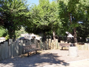
 These benches at the end of Glacier Place, along South Cline Alley, help beautify the surrounding streets as well as the park itself. Photo by queerbychoice.


