Bodies of water in the Yuba-Sutter area include all of the following. For recreational information, see Boating, Swimming, or the page of the specific body of water you're interested in.
Rivers
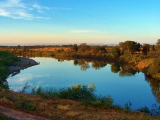
 The Feather River, seen from Yuba City. Photo by queerbychoice.
Major Boating Lakes
Other Lakes and Ponds
Yuba County
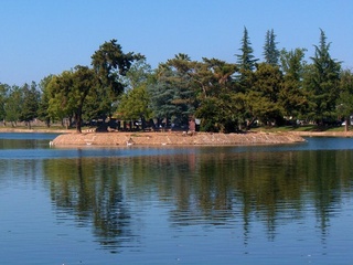
 Island in Ellis Lake. Photo by queerbychoice.
- Beale Lake
- Blackwelder Lake
- Bows End Pond
- Brownsville Pond
- East Lake
- Ellis Lake
- Frisky Lake
- Lake of the Springs
- Lake of the Woods
- Lower Blackwelder Lake
- Marysville Lake
- Messick Lake
- Miller Lake
- Sturgeville Pond
- Union Reservoir
Sutter County
- Abbott Lake
- Collins Eddy Lake
- Hiatt Lake
- Horseshoe Lake
- Lake Minden
- Long Lake
- Mary Lake
- McGriff Lakes
- Mystic Lake
- O'Connor Lakes
- Pleasant Oak Lake
- Purdue Lake
- Sills Lake
Creeks, Gulches, Ravines, Sloughs, Canals, and Ditches
Bear River Watershed
- Albion Ravine in Spenceville State Wildlife Area
- Algodón Slough in Plumas Lake
- Best Slough east of Plumas Lake
- Clark Slough in Arboga
- Dry Creek in Spenceville State Wildlife Area
- Cox Creek at Waldo Junction in Spenceville State Wildlife Area
- Daugherty Creek in Spenceville State Wildlife Area
- Dempsey Creek in Spenceville State Wildlife Area
- Grasshopper Slough northeast of Rio Oso
- Jones Creek in Spenceville State Wildlife Area
- Little Dry Creek in Spenceville State Wildlife Area
- Long Ravine at Camp Far West Lake
- Rock Creek at Camp Far West Lake
- Vineyard Creek in Spenceville State Wildlife Area
- Willow Glen Creek in Oregon House
- Yankee Slough north of Rio Oso
Feather River Watershed
- Bear River
- Early Creek northeast of Loma Rica
- Grizzly Creek northeast of Woodleaf
- Honcut Creek on the northern border of Yuba County
- Hutchinson Creek south of Olivehurst
- Jack Slough north of Marysville
- McGinn Creek east of Loma Rica
- Prairie Creek north of Browns Valley
- Reeds Creek southeast of Linda
- Simmerly Slough in Ramirez
- Tennessee Creek in northern Loma Rica
- Wellman Creek north of Beale Air Force Base
- Wildcat Ravine northeast of Rackerby
- Wilson Creek north of Ramirez
- Woodleaf Creek northeast of Woodleaf
- Yuba River
Sacramento River Watershed
- Auburn Ravine northeast of Catlett
- Butte Creek northwest of Meridian
- Coon Creek southeast of Trowbridge and Nicolaus
- Cross Canal in Verona
- Curry Creek east of Verona
- East Side Canal south of Trowbridge
- Feather River
- Howsley Creek southwest of Pleasant Grove
- King Slough south of Trowbridge
- Main Canal between Nicolaus and East Nicolaus
- Markham Ravine northeast of Catlett
- Natomas East Main Drainage Canal
- North Drainage Canal
- Ping Slough in Nicolaus
- Pleasant Grove Creek Canal in Pleasant Grove
- Sacramento Slough in Karnak
- Sutter Bypass
Sutter Bypass Watershed
- Butte Slough in Meridian
- East Canal east of Cranmore and west of Verona
- Farington Lateral northeast of Sutter
- Gilsizer Slough in Sutter National Wildlife Refuge
- Humphrey Lateral southeast of Sutter
- Little Blue Creek southeast of Sutter
- Morrison Slough west of Encinal
- Nelson Slough in Sutter National Wildlife Refuge
- Snake River southwest of Yuba City
- Sutter City Lateral northeast of Sutter
- Sutter County Extension Canal
- Tisdale Bypass in Sutter National Wildlife Refuge
- Wadsworth Canal on the eastern border of Sutter
Yuba River Watershed
Lower Yuba River Watershed
- Big Ravine in Timbuctoo
- Big Valley Creek in Frenchtown
- Brooks Creek west of Timbuctoo
- Chute Ravine southeast of Dobbins
- Costa Creek in Sharon Valley
- Deer Creek in Nevada County
- Dobbins Creek in Dobbins
- Dry Creek in Browns Valley
- French Ravine south of Dobbins
- Golden Gate Ravine northwest of Challenge
- Hogback Ravine northeast of Smartsville
- Indiana Creek north of Frenchtown
- Injun Creek south of Oregon House
- Keystone Creek northeast of Challenge
- Little Dry Creek in Browns Valley
- Long Valley Creek west of Frenchtown
- Maple Grove Creek east of Frenchtown
- Negro Bar Creek south of Oregon House
- New York Creek southwest of Sharon Valley
- Prince Albert Creek north of Frenchtown
- Sanford Creek in Timbuctoo
- Smoky Ravine in Oregon House
- Woods Creek south of Oregon House
Yuba River North Fork Watershed
- Brandy Creek in Camptonville
- Bridger Creek north of Camptonville
- Brushy Creek near Strawberry Valley
- Burnt Bridge Creek south of Greenville
- Campbell Gulch in Camptonville
- Canyon Creek east of Strawberry Valley
- Cassidy Ravine southeast of Strawberry Valley
- Cottage Creek at the south end of Bullards Bar Reservoir
- Dads Gulch northwest of Camptonville
- Deadwood Creek south of Strawberry Valley
- Diamond Ravine east of Strawberry Valley
- Empire Creek southeast of Woodleaf
- French Creek north of Camptonville
- Georgia Gulch south of Strawberry Valley
- Gold Run northeast of Strawberry Valley
- Gophner Ravine south of Strawberry Valley
- Hampshire Creek southwest of Strawberry Valley
- Horse Valley Creek northwest of Camptonville
- Indian Creek southwest of Woodleaf
- Jackass Creek south of Strawberry Valley
- Jaybird Creek north of Camptonville
- Kentucky Creek southeast of Strawberry Valley
- Little Oregon Creek southeast of Challenge
- Little Rock Creek northeast of Strawberry Valley
- Lost Creek east of Woodleaf
- Mill Creek west of Camptonville
- Mississippi Creek south of Strawberry Valley
- Missouri Creek southwest of Strawberry Valley
- Mosquito Creek southeast of Strawberry Valley
- Owl Gulch south of Strawberry Valley
- Quayle Ravine southeast of Strawberry Valley
- Rock Creek east of Strawberry Valley
- Schoolhouse Creek southwest of Camptonville
- Scott Ravine southwest of Strawberry Valley
- Simon Ravine northeast of North Star
- Slapjack Creek south of Woodleaf
- Slate Creek northeast of Strawberry Valley
- Stowman Ravine near North Star
- Whisky Creek south of Strawberry Valley
- Willow Creek north of Camptonville
Yuba River Middle Fork Watershed
- Clear Creek southeast of Bullards Bar Reservoir
- Fast Creek south of Camptonville
- Grizzly Gulch southwest of Camptonville
- High Point Ravine southwest of Camptonville
- Hornswoggle Creek southwest of Camptonville
- Little Willow Creek south of Camptonville
- Marys Ravine east of Dobbins
- Moonshine Creek southwest of Camptonville
- Mosquito Creek southwest of Camptonville
- Nevada Creek south of Camptonville
- Oregon Creek southwest of Camptonville
- Studhorse Canyon south of Camptonville
- Wagner Creek south of Camptonville
- Yellowjacket Creek east of Dobbins
Unidentified Watersheds
- Browns Valley Ditch
- Cordua Canal
- East Interception Canal
- Farm Ditch
- Live Oak Slough in Encinal
- Mahle Ditch
- Main Chandon Lateral
- North Main Canal
- Olive Hill Ditch
- Oroville Wyandotte Canal
- Ousley Ditch
- Sicard Flat Ditch
- Smith Bar Ditch
- Snake Slough
- Stahl Ditch
- Sunset Avenue Lateral
- Sutter Butte Canal
- West Interception Canal
- West Side Canal


