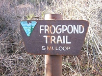
 Frogpond Trail at Cache Creek Natural Area provides great views of nearby Cortina Ridge and Blue Ridge Frog Pond Trail is an intermediate level hike in the Cache Creek Natural Area about 20 miles northwest of the town of Esparto along Hwy 16 (see maps). It's about an hour and a quarter from Davis. The trail goes through oak, grey pine and chemise habitats. There are panoramic views of the Cache Creek canyon, including Glascock Mountain and Fiske Peak.
The "trail" is now a road to within 100 yards of the frog pond. Do not follow the deer trail that goes up from the lower Frog Pond Trail sign. Instead proceed up the road about 1/4 mile to the second Frog Pond Trail sign, Turn right and proceed about 2 miles to the fire break on the top of the ridge. Go left up the fire break about 300 yards and you should see the trail to the pond. Currently the pond is bone dry (November 25, 2018).
Hiking Trip Reports
- Cache Creek Natural Area, Frogpond Trail - BRT Insights 30jan2012
- Frog Pond Trail - Justinsomnia 03may2009
- Frog Pond Trail photos - heringermr 29may2005
- Frog Pond Trail - yolohiker
- Frog Pond Trail at Cache Creek Rec. Area - Oh, Ranger!
 Glascock Mountain is the highest point on Cortina Ridge
  Fiske Peak is the highest point on Blue Ridge
  Frog Pond Reservoir
Maps
Managing Agencies
- Cache Creek Natural Area, Bureau of Land Management California Frogpond Trail & other trails nearby.
- Cache Creek Regional Park -Yolo County government Blue Ridge Trail and Frog Pond Trail - access from Road 40 area that leads to trail heads and BLM lands.
More nearby: Hiking in Yolo County.


Comments:
You must be logged in to comment on this page. Please log in.