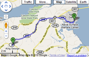
Our Limited Use Screenshot, also referred to as Google Screenshot page documents the use of screen captures from Google Maps or other applications that allow embedding.
Such screen capture images should not be reused under the Creative Commons licensing of the wiki unless they are annotated and linked in a manner consistent with that used here on FredWiki.
The screenshots are stored and displayed on FredWiki as annotated graphic images instead of using the option of embedding the display on the wiki.
Unfortunately, WikiSpot does not allow embedded code segments, such as are needed to embed a Google Map on the wiki. WikSpot does have a Google API key and uses Google Maps to display data via the Map button on the tabs above.
We assume, that using a graphic depiction of what would otherwise be displayed via embedded maps is within the copyright usage of the image so long as the page includes a link to the respective Google map that generated the graphic.
All Google Screenshots on FredWiki should include a link to this page and the appropriate link to the generating Google Map.
Example
Dahlgren Road
 Limited Use Screenshot, Google Map Dahlgren Road, also designated Route 206, is a main route that runs 12.5 miles west to east across parts of King George County from an intersection with Route 3 at Arnolds Corner to the entrance of the Dahlgren Naval Surface Warfare Center in Dahlgren, VA. The road continues under that name on the base until it terminates at Tisdale Road.
Notes and References
- Virginia_State_Route_206
- Road overlaps with portions of Route 218.
- Google Map Dahlgren Road


