Greater Syracuse Area
The Greater Syracuse Area normally refers to the Census Bureau's Syracuse Metropolitan Statistical Area (MSA) or the wider Combined Statistical Area (CSA) as shown below.
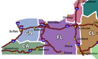
 ILoveNY.com Regions New York State breaks down into named regions, with the Syracuse Area falling within the northeast corner of the Finger Lakes Region. As part of that region, our focus extends west toward Rochester and south toward Corning and the Southern Tier. To the east, Syracuse borders on the Central Leatherstocking Region, which includes Binghamton and the eastern end of the Southern Tier. On the north Syracuse borders the Thousand Islands Region.
Other Perspectives on the Syracuse Area:
- anywhere that provides a one hour (or less) commute to work
- anywhere the Post-Standard is sold in stores
- membership in the Greater Syracuse Chamber of Commerce
See also:
Syracuse MSA
 Edit from Wikimedia The Syracuse MSA (Metropolitan Statistical Area) describes a demographic area consisting of the Western NY counties of Onondaga, Oswego, and Madison and anchored by the City of Syracuse. It is the fifth largest MSA in New York with a 2006 population of 650,051. The MSA is shown in red in the map at right. Cayuga County (Auburn Micro-Statistical Area), in blue, is included in the Syracuse-Auburn Combined Statistical Area (CSA) with a combined 2007 estimated population of 725,359. 1
The other major areas of Western NY include the Rochester Combined Statistical Area bordering our CSA on the west, the Buffalo-Niagara Falls MSA, further west, and Albany-Schenectady-Amsterdam NY CSA to our east.
Footnotes
1. Wikipedia


