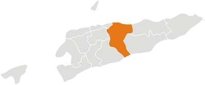
Manatuto District
Located in the central part of the country; it reaches both the south and north coasts of the island. It borders the Strait of Wetar to the north; the districts of Baucau and Viqueque to the east; the Timor Sea to the south; and the districts of Manufahi, Aileu and Dili to the west. It has a population of 42.742 inhabitants (Census 2010) and an area of 1.706 km². The capital of the district is also named Manatuto. The longest river in Timor-Leste, the Laclo river, reaches the sea near Manatuto, between the Ponta de Subaio and Lanessana bay. Manatuto comprises the subdistricts of Barique-Natarbora, Laclo, Laclubar, Laleia, Manatuto and Soibada. In addition to the official languages (Tetun and Portuguese), the majority of the population speaks Galóli, which is recognized as a “national language” by the Constitution.


