Site Capacity and Perimeter Totals
Reclaim Canada Day! City-Wide #TOStrike Garbage Protest, Noon, Toronto City Hall http://T.oronto.ca/2nz pls RT
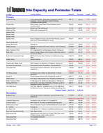
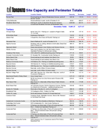
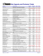
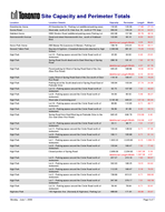
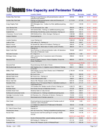
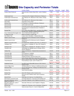
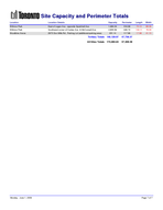
Page 1 Capcaity Location Location Details Site Capacity and Perimeter Totals Perimeter Length Width Primary Caledonia Park 1135 Caledonia Rd., (East side of Caledonia, north of Lawrence - rear of Ambulance Station)-Parking Lot(additional parking area) 281.21 152.10 17.68 58.52 Christie Pitts North of Bloor Street West, Paved roadway east of Crawford Street 494.95 609.60 298.70 6.10 Earlscourt Park Entrance to Park yard paved 111.31 64.01 17.68 23.16 Earlscourt Park Parks yard, fenced paved lot 414.14 160.93 49.99 30.48 Eglinton Flats Eglinton Flats Eglinton Flats Eglinton Park North of Eglinton Avenue, east of Oriole Parkway, west of Edith Drive, Paved parking lot to Arena 916.67 234.70 50.29 67.06 Etienne Brule Park George Bell Arena Parking Lot 1,515.15 149.35 73.15 76.20 Haldon Avenue Parking Lot at dead end of park roadway, north of Cosburn Avenue 2,449.00 188.98 93.54 96.32 Metro Treatment Plant 201 Copperfield Rd. (at Beechgrove Road), Parking Lot 1,177.02 276.15 89.92 48.16 Moss Park South of Shuter Street, north of Queen Street East, east of Sherbourne Street 3,535.35 457.20 106.68 121.92 North York Centennial Centre 580 Finch Avenue West, Parking Lot (additional parking area) 1,042.73 259.99 45.11 85.04 Saulter Street Asphalt roadway 376.52 169.16 Additional Length/Width 108.20 3.05 108.20 9.75 Scarborough Village Arena 3600 Kingston Rd.(Markham & Kingston), Parking Lot 933.33 259.99 93.88 36.58 Sir Casmir Gzowski Park Parking area south of Lakeshore, most westerly lot 252.50 30.18 30.78 Sunnyside Park Parking area south of Lakeshore, first lot east of the westerly lot 1,545.45 584.00 Additional Length/Width 3.05 274.32 17.68 274.32 Ted Reeve Arena Northeast corner of Main St. & Gerrard St. E. Paved parking lot 1,250.00 137.16 54.86 83.82 Villiers St. Paved roadway between Don Roadway & Saulter St. 820.71 76.20 198.12 15.24 Villiers Street North leg of Villers between Don Roadway & Munition St. 1,242.42 1,018.03 499.87 9.14 Water Treatment Plant 51 Beechgrove Dr. (Bottom of Beechgrove), Parking Lot 747.47 212.14 60.96 45.11 Wishing Well Park North of 401, west side of Pharmacy (Pharmacy south of Sheppard Avenue), Parking Lot 838.19 221.89 57.00 54.10 York Mills Arena 2539 York Mills Rd., southeast corner of York Mills Road and Bayview Avenue, Parking Lot (Additional parking area) 329.17 149.96 24.08 50.29 20,273.31 5,381.55 Primary Totals Secondary Budapest Park Parking area south of Lakeshore, second lot east of the westerly lot 1,124.24 547.42 Additional Length/Width -1.52 256.03 17.68 256.03 Campbell Playground Southeast corner of Antler St. & Campbell St. 1,893.94 335.28 76.20 91.44 Cummer Arena 6000 Leslie St., Parking Lot (additional parking area) 299.12 132.89 31.39 35.05 Dufferin Grove Park West of Havelock Avenue, baseball diamond & soccer field 1,670.45 320.04 64.01 96.01 E. T. Seaton Parking Lot 961.95 239.27 53.31 66.39 Earl Bales Park 4169 Bathurst St., Parking Lot (additional parking area) 407.93 185.93 24.99 60.05 East York Community Centre 1081 Pape Avenue 461.36 82.60 38.40 44.20 Greenwood Park Internal paved road north from Dundas Street East, West of Green Avenue, east of Aldon Avenue 136.36 281.64 3.66 137.16 Greenwood Park Two baseball diamonds 1,856.06 341.38 64.01 106.68 Greenwood Park Soccer field 1,520.20 298.70 65.53 85.34 Page 1 of 7 Monday, June 1, 2009 Page 2 Capcaity Location Location Details Site Capacity and Perimeter Totals Perimeter Length Width Rennie Park Paved parking lot, East of Windermere Avenue, north off Rennie Terrace 443.18 173.74 59.44 27.43 Trinity-Bellwoods Paved pathways in park, south of Dundas St. W. 60.61 665.07 91.44 2.44 Woodbine Beach Park Parking lot, south of Lakeshore Boulevard, between Coxwell and Woodbine Avenues (at Boardwalk Café) 2,845.96 667.51 35.05 298.70 13,681.37 4,271.47 Secondary Totals Tertiary 18 Dyas Road North York CCA - Parking Lot - Leased to Rogers Cable TV, On hold. 927.68 137.16 68.28 49.99 30 Northline Road Employees Parking lot 742.50 241.40 30.18 90.53 Adams Park 2 Rosell Rd. (Port Union off Rozell), Parking Lot 846.26 417.88 Additional Length/Width 173.13 -17.98 173.13 35.97 Alexandra Park East of Bathurst St., south of Dundas St. W. 2,020.20 365.76 60.96 121.92 Algoma Avenue Roadway with no curbing, ditched on both sides (Dead End East of Grand Ave) 385.10 387.10 7.62 185.93 Algonquin Island Grass area between Inner Harbour and Seneca Avenue 596.36 614.48 7.32 299.92 Allenby Avenue East Limit of Allenby Ave. @ Old Outdoor Arena. Asphalted Parking Lot with precast curbing 455.45 167.64 32.92 50.90 Amesbury Park Arena 155 Culford Rd. (additional parking area) Parking Lot 271.16 89.00 27.74 35.97 Ancaster Community Centre 41 Ancaster Rd., Community Centre Parking Lot 134.94 110.03 11.43 43.43 Balmy Beach Park Paved parking lot and roadway from Beech Ave. 36.36 196.29 5.49 24.38 Balmy Beach Park Paved parking lot and roadway from Beech Ave. 234.39 196.29 15.54 55.47 Banbury Community Centre 120 Banbury Rd., Parking Lot (additional parking area) 336.72 175.87 17.98 68.88 Baycrest Arena 160 Neptune Dr., Parking Lot (Additional parking area) 279.37 96.93 17.60 58.40 Bayview Arena 3230 Bayview Ave., Parking Lot (additional parking area) 178.80 117.96 14.94 44.04 Bayview Avenue East side, north of Bloor St (snow dump) 2,727.27 420.62 137.16 73.15 Bayview Avenue west side, north of Bloor St.(snow camp) 2,363.64 118.87 118.87 73.15 Bayview Village Park 2957-2961 Bayview Ave. (East side of Bayview, north of Foxwarren) Parking Lot 221.99 127.10 17.98 45.42 Beechwood Road to Pottery Road Snow Dump Road 1,371.21 1,667.26 6.10 827.53 Belbury Park 99-39 Van Horne Ave.(Van Horne east of Seneca Hill), Parking Lot 229.42 120.09 24.08 35.05 Blue Haven Park Blue Haven Cr. (East side of Blue Haven Public School), Parking Lot 497.98 174.96 35.36 51.82 Bond Street Park 167 Duncairn Avenue, North of lawrence Avenue, Parking Lot (Dead end of Duncairn) - (additional parking area) 232.46 135.03 17.37 49.23 Boulton Dr. Parkette West side of Boulton Dr. north of Cottingham 568.18 228.60 91.44 22.86 Broadlands Park 19 Castlegrove Blvd., Outdoor Ice Rink 219.17 131.98 20.12 40.08 Carlton St. Layby North side between Sumach St. & east dead end 166.67 213.36 100.58 6.10 Carstowe Road Carstowe Road / Maclellan Avenue, West of Mt. Pleasant to Old Bridal Path Road. 2,402.02 91.44 Additional Length/Width 1.52 999.74 7.32 999.74 Cedarbrook Community Centre 91 East Park Blvd.(Eastlea at Markham), Parking Lot 582.54 199.95 69.34 30.91 Cedarridge Arts Centre 225 Confederation Dr., Arts Centre Parking Lot 282.50 130.15 34.44 30.18 Centennial Park 3 Parking Lots (West side of Park off Centennial Park Blvd. - Curbed and Asphalted Parking Lot * 965.96 257.86 39.93 89.00 Centennial Park 3 Parking Lots (West side of Park off Centennial Park Blvd. - Gravel/Limestone base with precast curbing - Parking Lot* 473.79 229.82 17.98 96.93 Centennial Park 3 Parking Lots (West side of Park off Centennial Park Blvd. - Gravel/Limestone base with precast curbing - Parking Lot * 552.75 284.07 16.15 125.88 Charlottetown Community Centre 5450 Lawrence Ave. E. (Lawrence west of Port Union), Basketball Pad 168.75 99.97 30.18 20.57 Page 2 of 7 Monday, June 1, 2009 Page 3 Capcaity Location Location Details Site Capacity and Perimeter Totals Perimeter Length Width Chorley Park Closed portion of road through the park behind Roxborough Dr. east of Glen Rd., to Douglas Dr. 560.61 512.06 Additional Length/Width 3.05 225.55 6.10 225.55 Clairlea Soccer Centre 45 Fairfax Rd. (Fairfax west of Warden), Parking Lot 824.87 227.99 71.63 42.37 Clarke Beach Park Large lot at the foot of Cherry Street 2,272.73 365.76 91.44 91.44 Clarke Beach Park South dead end of Cherry Street, access roadway to parking lots 113.64 192.02 4.57 91.44 Clarke Beach Park South dead end of Cherry Street, first lot westerly 545.30 252.98 18.59 107.90 Clarke Beach Park South dead end of Cherry Street, easterly gravel lot 806.06 262.74 28.96 102.41 Colonel Samuel Smith Park South Parking Lot & Driveway with precast barrier curbs, off Lakeshore @ Kipling 249.75 276.15 7.01 131.06 Colonel Samuel Smith Park South Parking Lot with precast barrier curbs & Driveway off Lakeshore @ Kipling 500.61 176.17 34.14 53.95 Commander Arena 140 Commander Blvd.(Commander, south of Huntingwood), Parking Lot 1,136.01 266.09 50.60 82.60 Commissioners Street Bouchette St. to Saulter St. 353.54 323.09 152.40 8.53 Commissioners Street From Saulter St. to Don Roadway 325.25 298.70 140.21 8.53 Cottingham Street Asphalt roadway 309.09 240.79 109.73 10.36 Curran Hall Community Centre 277 Orton Park Blvd. (Orton Park south of Ellesmere), Parking Lot 156.44 99.97 32.00 17.98 Dead end of Skagway to McCowan Rd. (Enter off Brimley, south of Eglinton) 2,014.26 473.96 200.10 37.03 Dentonia Park Dentonia East of Dawes. 2 Baseball diamonds & Football field 4,515.00 525.78 105.61 157.28 Dieppe Park Memorial Park Avenue East of Greenwood. Currently under renovations. 1,375.00 412.09 40.23 125.73 Douro Street King Street to Crawford Street 913.43 60.96 Additional Length/Width 100.58 14.02 199.95 9.75 Driftwood Community Centre 4401 Jane St., Parking Lot (additional parking area) 174.38 114.91 15.09 42.52 Earlscourt Park Southeast corner of St. Clair Avenue West and Caledonia Park Road. 1,823.23 347.47 57.91 115.82 Earlscourt Park South off St. Clair Ave. W., paved roadway 445.45 608.38 298.70 5.49 East of Victoria Park, north of Gerrard St. E., south of tracks East of Victoria Park, north of Gerrard St. E., south of tracks 3,267.58 600.15 149.96 80.16 East side of McCowan, south of Bushlay Drive East side of McCowan, south of Bushlay Drive, Parking Lot 945.56 244.14 77.11 45.11 East York Curling 901 Cosburn Avenue 1,687.73 204.22 85.95 72.24 Edithvale Community Centre 7 Edithvale Dr., Parking Lot 260.00 135.03 20.12 47.55 Ellesmere Community Centre 20 Canadian Rd.(Warden & Ellesmere), Parking Lot 554.81 199.95 69.04 29.57 Esther Shiner Stadium 5270 Bathurst St., Parking Lot (Additional parking area) 339.60 149.96 24.99 49.99 Fenside Arena 30 Slidell Cres., Parking Lot (additional parking area) 151.97 98.76 17.98 31.09 Flemington Park Arena 165 Grenoble Dr., Parking Lot 482.95 184.10 27.43 64.77 Fountainhead Park 445 Sentinel Rd., Skating Rink - Parking Lot 198.64 120.09 17.37 42.06 Fountainhead Park 445 Sentinel Rd., Skating Rink - Ice Rink 200.00 0.00 24.38 30.18 Frobisher Ave Frobisher Ave. between Lascelles & Oriole Pkway 662.63 519.38 9.75 249.94 Glebe Manor Square Belsize Dr., grass island Wilfred Ave. to Acadia Road 1,666.67 463.30 201.17 30.48 Glen Long Park 35 Glengrove Ave., Parking Lot 164.04 104.85 17.07 35.36 Glen Manor Road Dead end street Glen Manor Rd., south of Hubbard Blvd. 87.83 73.76 Additional Length/Width 3.05 28.65 8.23 28.65 Glen Stewart Park North of Pine Cres., south of Pine Glen Rd. 787.88 330.10 22.86 126.80 Glen Watford Community Centre 31 Glen Watford Dr. (Glen Watford & Sheppard), Parking Lot 673.64 212.14 34.75 71.32 Glendora Park 201-205 Avondale Ave. (dead end of Avondale, east of Yonge), Tennis Court 321.82 138.07 32.92 35.97 Gord & Iren Risk Arena 2650 Finch Ave. W.(additional parking area) Parking Lot 324.09 163.98 18.90 63.09 Goulding Arena 45 Goulding Ave., Parking Lot(additional parking area) 200.38 111.86 21.03 35.05 Page 3 of 7 Monday, June 1, 2009 Page 4 Capcaity Location Location Details Site Capacity and Perimeter Totals Perimeter Length Width Grandravine Arena 23 Grandravine Dr., Parking Lot (additional parking area) 132.60 120.09 17.98 27.13 Gunns Road West side, north of St. Clair Ave. W., north of TTC loop 350.00 104.24 20.12 64.01 Habitant Arena 3383 Weston Road (additional parking area) Parking Lot 402.98 157.89 30.78 48.16 Hammersmith Avenue Dead end street Hammersmith Ave., south of Hubbard Blvd. 122.83 95.10 Additional Length/Width 3.05 39.01 8.53 39.01 Heron Park Arena 298 Manse Rd.(Lawrence & Manse), Parking Lot 728.79 210.01 59.44 45.11 Heward Talbot Park Bayview & Eglinton. 2 baseball diamonds attached to High School 2,363.96 381.61 75.29 115.52 High Park Lot 10 - Parking space around the Circle Road north of restaurant. 45.08 64.62 6.40 25.91 High Park Spring Road South dead end to East West leg of Spring Road 298.18 191.41 Additional Length/Width 4.57 87.78 7.92 87.78 High Park Paved parking lot West of Spring Road East of the Zoo (Deer Run Road) 445.20 168.86 Additional Length/Width 6.10 65.53 18.90 65.53 High Park Layby West of Spring Road East of the Zoo south of Deer Run Road 118.18 169.47 5.49 79.25 High Park Parking lot at the South dead end of Spring Road East of Parkside Drive 183.84 103.94 27.74 24.38 High Park Lot 12 - Parking space around the Circle Road north of restaurant. 92.73 107.90 7.32 46.63 High Park Lot 8 - Parking space around the Circle Road north of restaurant. 54.09 83.52 5.49 36.27 High Park West side of swimming pool 3,181.82 445.01 137.16 85.34 High Park Lot 16 - Parking space around the Circle Road north of restaurant. 88.89 110.95 6.71 48.77 High Park Lot 15 - Parking space around the Circle Road north of restaurant. 59.39 81.08 6.40 34.14 High Park Spring Road from East/West leg at Parkside Drive to the Zoo road (Deer Run Road) 945.45 646.79 Additional Length/Width 316.99 4.57 316.99 6.40 High Park Lot 13 - Parking space around the Circle Road north of restaurant. 33.11 48.77 7.01 17.37 High Park Lot 11- Parking space around the Circle Road north of restaurant. 104.44 128.02 6.71 57.30 High Park Lot 9 - Parking space around the Circle Road north of restaurant. 166.11 195.68 6.71 91.14 High Park Lot 1 - Parking space around the Circle Road north of restaurant. 1,822.22 2,223.82 6.10 1,099.72 High Park Lot 6 - Parking space around the Circle Road north of restaurant. 153.94 169.47 7.32 77.42 High Park Closed portion of Spring Road 2,909.09 2,204.92 Additional Length/Width 1,097.28 4.57 1,097.28 5.18 High Park Lot 5 - Parking space around the Circle Road north of restaurant. 207.07 215.19 7.62 99.97 High Park Lot 4 - Parking space around the Circle Road north of restaurant. 342.63 168.25 19.51 64.62 High Park Lot 3 - Parking space around the Circle Road north of restaurant. 112.05 169.47 5.18 79.55 High Park Lot 2 - Parking space around the Circle Road north of restaurant. 728.89 813.21 6.71 399.90 High Park Lot 7 - Parking space around the Circle Road north of restaurant. 347.90 379.17 7.01 182.58 High Park Lot 14 - Parking space around the Circle Road north of restaurant. 59.44 78.64 6.71 32.61 Highview Park 150 Highview Ave. (Kennedy & Highview), Parking Lot 488.69 171.91 49.99 35.97 Page 4 of 7 Monday, June 1, 2009 Page 5 Capcaity Location Location Details Site Capacity and Perimeter Totals Perimeter Length Width Humber Bay Park East Parking Lot and Driveway with precast barrier curbs off Lakeshore @ Parklawn 493.94 608.38 6.10 298.09 Humber Bay Park East Parking Lot with precast barrier curbs and Driveway off Lakeshore @ Parklawn 2,174.24 377.95 64.01 124.97 Irving Chapley Park 205 Wilmington Ave., Outdoor Ice Rink (additional parking area) 219.17 120.09 20.12 40.08 Jean Sibulus Park On the Brunswick Ave., side 505.05 198.12 30.48 60.96 John Booth Arena 230 Gosford Blvd., Parking Lot (additional parking area) 266.01 167.94 28.04 34.90 Knobhill Park 625 Brimley Rd.(Brimley south of Seminole), Parking Lot 234.62 134.11 17.37 49.68 L'Amoreaux Tennis Centre 2000 McNicoll Ave. (Silver Springs), Parking Lot 1,060.68 289.86 109.42 35.66 Lamport Stadium Paved parking lot 1,068.94 256.64 Additional Length/Width -50.60 77.72 50.60 155.45 Leaside Gardens Lower Parking Lot 1,069.20 259.38 48.28 81.47 Ledbury Park 146 Ledbury St., Parking Lot 165.45 99.97 21.95 27.74 Malvern Arena 30 Sewells Rd. (McLevin & Neilson), Parking Lot 558.33 277.98 122.53 16.76 Maple Leaf Park 330 Culford Rd. (West side of Culford, north of Rustic), Parking Lot 386.64 191.11 18.59 76.50 Marie Curtis Park West Parking Lot with precast barrier curbs, off Lakeshore West side of Etobicoke Creek. 760.86 229.21 35.05 79.86 McCords Concrete 611 King St. E. 6,335.35 0.00 195.07 119.48 McGregor Arena 2231 Lawrence Ave. E.(Lawrence west of Kennedy), Parking Lot 348.64 142.04 35.97 35.66 Memorial Park North of Chaplin Crescent, West of Spadina, Forest Hill Arena- Parking lot 868.94 223.72 Additional Length/Width 3.05 67.67 44.20 67.67 Memorial Park Paved driveway North side of Arena 76.01 139.60 4.27 65.53 Mid-Scarborough Arena 2467 Eglinton Ave. E. (Eglinton west of Midland), Parking Lot at rear 633.11 288.04 18.59 125.27 Milliken Park 5555 Steeles Avenue East (Steeles west of Middlefield Avenue), Parking Lot 2,795.35 412.09 83.52 123.14 Mitchell Field Arena 89 Church Ave. 308.11 363.93 14.94 75.90 Mitchell Field Arena 89 Church Ave., Parking Lot 317.35 166.12 17.98 64.92 Monarch Park Paved internal parks road 196.97 326.14 4.57 158.50 Moore Vale Park West of Mt. Pleasant, south of Moore Ave. 818.18 219.46 54.86 54.86 Nearartic Drive Between Hwy 27 & Queens Plate Dr. Asphalted roadway in undeveloped area 333.74 271.27 9.75 125.88 Neilson Park 1575 Neilson Rd. (Neilson south of Finch), Parking Lot 1,030.73 280.11 104.55 36.27 Northline Road from Dome Avenue to Waterman Avenue 415.35 332.84 9.75 156.67 Northline Road Yard Westerly Gate to Curity Avenue 316.77 258.47 9.75 119.48 Northwood Community Centre 15 Clubhouse Crt., Parking Lot(additional parking area) 132.60 89.92 17.98 27.13 Oakridge Community Centre 63 Pharmacy Ave. (Pharmacy & Denton), Parking Lot 712.50 210.01 41.15 63.70 Otter Creek West dead end of Cheritan, paved lot 202.02 121.92 Additional Length/Width 3.05 60.96 9.14 60.96 Otter Creek Paved parking lot at east dead end of Cheritan south of Lawrence, east of Rosewell 197.98 0.00 42.67 17.07 Pelmo Park 171 Pellatt Ave.(dead end of Pellat east of Wendell), Parking Lot 182.42 111.86 17.07 39.32 Pk. Vista & Dawes Road Parking Lot 212.85 122.53 18.11 43.25 Pleasantview Arena 545 Van Horne Ave., Parking Lot(additional parking area) 204.34 114.00 17.07 44.04 Rennie Park Paved access road from parking lot running to Waller Avenue. 106.06 131.06 Additional Length/Width 6.10 4.57 6.10 59.44 Riverdale Park South of Montcrest Blvd., paved roadway around pool 247.47 60.96 298.70 3.05 Roding Arena 600 Roding St., Parking Lot 211.16 124.05 17.22 45.11 Rosedale Park West of Mt. Pleasant, south of Whitehall Road 1,707.07 335.28 79.25 79.25 Page 5 of 7 Monday, June 1, 2009 Page 6 Capcaity Location Location Details Site Capacity and Perimeter Totals Perimeter Length Width Scarboro Beach Boulevard Dead end street Scarboro Beach Blvd., south of Hubbard Blvd. 97.88 79.25 Additional Length/Width 3.05 31.09 8.53 31.09 Scarborough Arena 75 Birchmount Rd. (Kingston & Birchmount), Parking Lot 953.03 244.14 77.72 45.11 Scarborough Centennial Arena 1967 Ellesmere Rd. (Ellesmere & Dolly Varden), Parking Lots 795.61 235.00 35.97 81.38 Scarborough Centennial Arena 1967 Ellesmere Rd. (Ellesmere & Dolly Varden) 989.12 262.13 91.14 39.93 Shaw Street King Street to Douro Street 243.94 30.48 64.01 14.02 Shawnee Park 87 Shawnee Cir. (Shawnee at Micmac), Parking Lot 147.50 96.01 17.98 30.18 Sherwood Park South of park access road 1,010.10 304.80 30.48 121.92 Sherwood Park Paved park access road at east deadend in Sherwood Park 494.95 609.60 298.70 6.10 Sherwood Park Paved parking lot at deadends between Sheldrake & Sherwood 393.94 228.60 99.06 14.63 Skymark Park N.W. corner of Don Mills & Finch - west side of Don Mills at Skymark Drive, Parking Lot (additional parking area) 516.49 185.93 34.44 55.17 Soccer Field behind Morningside Yard Soccer Field behind Morningside Yard 8,696.97 719.94 199.95 160.02 St. Alban's Sq. Park Barton & Howland; on Barton side 1,010.10 335.28 121.92 30.48 Stan Wadlow Park Cosburn East of Woodbine. 2 Baseball diamonds 2,426.14 379.17 92.96 96.01 Stephen Leacock Arena 2500 Birchmount Rd. (Birchmount north of Sheppard), Parking Lot 539.80 180.14 39.01 50.90 Stephen Leacock Arena 2500 Birchmount Rd. (Birchmount north of Sheppard), Parking Lot 506.06 174.04 36.58 50.90 Tallpines Community Centre 64 Rylander Blvd. (Rylander north of Hwy. 2), Parking Lot 158.66 99.97 31.39 18.59 Teddington Park Grass Island on Teddington Pk. West of Mt. Pleasant to Bocastle 185.61 307.85 4.57 149.35 Teddington Park Grass island on Teddington Pk., Bocastle to Yonge St. 185.61 307.85 4.57 149.35 Thompson Park 1005 Brimley Rd. (Birkdale Ravine on Brimley north of Dorcot), Parking Lot 217.51 131.98 16.31 49.07 Todham Park Selwyn and Westview. 2 Baseball diamonds attached to school 1,550.00 357.84 40.23 141.73 Todmorden Mills Front Parking Lot. Hardpath 303.17 295.05 17.10 65.23 Todmorden Mills Back Parking Lot hardpath 289.85 130.45 34.20 31.18 Trinity-Bellwoods Roadway into park, north from Queen St W 878.89 977.80 482.19 6.71 Trinity-Bellwoods North of Queen Street West, west of Gore Vale Avenue, East of Crawford Street, Soccer field, 2 baseball diamonds 3,056.19 457.20 156.97 71.63 Trinity-Bellwoods Paved pathways in park, south of Dundas St. W. 147.88 365.76 Additional Length/Width 91.44 2.44 87.78 3.66 Vanderhoof Avenue from 900 ft west of Brentcliffe Avenue to 100 ft. North of Research Road 969.70 798.58 9.14 390.14 Victoria Village Arena 190 Bermondsey Rd., Parking Lot (additional parking area) 849.32 252.07 33.83 92.35 Viewmount Park 167-215 Viewmount Ave., Parking Lot (at Shermount Ave - driveway to end) 203.59 120.09 17.68 42.37 Wanless Park Gravel road into building 191.92 243.84 Additional Length/Width 115.82 3.05 115.82 3.05 Wanless Park East of Mt. Pleasant, north of Lawrence Ave. 1,794.19 335.28 88.39 74.68 Wards Island Park area north of Withrow Street, east of Lakeshore Avenue 1,237.37 298.70 42.67 106.68 Wells Hill Park South side of St. Clair Ave. W. at Wells Hill Ave. 94.70 76.20 15.24 22.86 West Rouge Community Centre 270 Rouge Hills Drive, Community Centre Parking Lots 618.96 195.07 38.71 58.83 West side of Markham, north of Eglinton off Centre St. West side of Markham, north of Eglinton off Centre St. 2,627.58 121.31 114.91 84.12 West side of McCowan, south of Eglinton to Skagway West side of McCowan, south of Eglinton to Skagway 1,813.30 434.04 180.14 37.03 Wexford Park Singleton Rd. (Pharmacy north of Ashtonbee), Parking Lot 286.06 153.01 58.52 17.98 Wineva Street Dead end street Wineva St., South of Hubbard Blvd. 79.42 68.28 Additional Length/Width 3.05 25.91 8.23 25.91 Page 6 of 7 Monday, June 1, 2009 Page 7 Capcaity Location Location Details Site Capacity and Perimeter Totals Perimeter Length Width Withrow Park East of Logan Ave., opposite Sparkhall Ave. 1,684.34 316.99 70.10 88.39 Withrow Park Southwest corner of Carlaw Ave. & McConnell Ave 2,855.56 426.72 134.11 78.33 Woodbine Arena 2975 Don Mills Rd., Parking Lot (additional parking area) 201.14 117.96 17.98 41.15 140,129.97 47,756.37 Tertiary Totals 174,084.65 57,409.38

