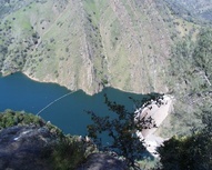
 Overlooking Lake Berryessa
Next to Lake Berryessa, the Stebbins Cold Canyon Reserve loop trail winds its way up to the southern peak overlooking Monticello Dam in Solano County. The hike is a bit of a scramble and climb at the end. It gains over 1000ft in half a mile! Although not visible in the photo on this page, from a spot along this trail you can see the glory hole.
For more local hikes see:
- Hiking Trails of Solano County
- Hiking Trails of Napa County
- Hiking Trails in Yolo & Colusa Counties.
StevenDaubert went on this hike with his faja a couple of years ago, it was enjoyable.
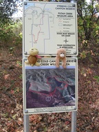
 I took this picture of the trail map on 19 Sept 2010. Can anyone familiar with the area tell me how to get to the Top of the World from this point? Sorry for the sideways picture, I have no idea how to edit photos on the computer I am using right now. —JenniferCook
- The the squiggly line that goes straight up the ridge is roughly the way up. Near the top there will be a unmarked and lightly traveled path off to the main trail heading towards the north. It leads to a rock outcropping where the photo at the top of the page was taken. The last time i was there, in June, you could hardly see the path and the way was well protected by poison oak. So, if you're prepared to do some bushwacking you can get to the view of the dam otherwise it's not an option. (unless the trails crew makes opening up the path a priority this winter) —ARWENNHOLD


Comments:
You must be logged in to comment on this page. Please log in.