An Currach Beag or Currabeg is a townland of 99 hectares or 245 acres and in the early part of the 20th century, 130 individual fields were mapped in this townland.
It is in the Electoral Division of Castlehaven North, in Civil Parish of Castlehaven and the Roman Catholic Parish of Castlehaven and Myross.
An Currach Beag is bordered by An Achaill (Aghill) to the north, Fornocht (Forenaght) to the east, Cill Achaidh Aingle (Killangal) and An Ráithín (Raheen) to the south and Leitir an tSinlis (Lettertinlish) and Muine Uí Mhothlacháin (Moneyvollahane) to the west
OpenStreetmap contributors, with input from the Castlehaven & Myross History Society, have created a detailed townland map including all its minor placenames. Zoom in for further detail.
Etymology
An Currach Beag can be interpreted as the small bog/marsh. However it was given by Bruno O'Donoghue as Corra Bheag which would be a small round hill. However it might also derive from Cora Beag (a small weir)
History
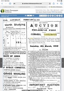
Eviction: Jeremiah Cadogan moved to this townland around 1849/1850 when he was expelled from Rea during the infamous evictions of that period. For more detail see the history section from the Bluid West townland
Suspicious Death: There was a suspicious death in Currabeg in 1895 when a local man was found dead with his arms and legs bound. The coroners report in the Southern Star suggested that he may have died accidentally.
Forge: There was a blacksmith's forge at the crossroads known as Bleaches Cross. This was started by Timsie Whooley in 1896/97 and was funded by local subscriptions. Timsie died in 1947
Currabeg Fair: A fair was held up to about 1870. The location is still known as the Fair Field today
Housing
As part of Griffiths Valuation in 1853, a survey of house quality was carried out to calculate what rates were due by each household. These were issued in 1850 in the form of house books (Pg 1, Pg 2) and a guide on how to interpret these can be seen here. These show that all 15 houses in the townland at the time were class 3. This means that they were all thatched houses with stone walls with mud or puddle mortar (as opposed to houses built with stone or brick and lime mortar). Within class 3 there are a number of different categories. 6 of these houses are old (more than 25 years old) but in repair while the other 9 are described as being old (more than 25 years) but out of repair. All of the houses in the townland at this time are between 5 foot (!) and 6 foot 9 inches tall which indicates that they are single storey at this time.
By the 1901 census, there are now just 8 occupied houses in this townland at this time and all have walls of stone, brick or concrete. Four still have thatched roofs while the other four have roofs of slate, iron or tiles. Six houses have two, three or four rooms with two having one window in front, three having two windows (indicating that they are probably still single storey) and the remaining one having five windows in front. The remaining two houses have five or six rooms with one having three windows in front while the other has five windows.
When we advance to the 1911 census there are now 7 occupied houses in this townland and, not surprisingly, all still have walls of stone, brick or concrete. Four still have roofs of slate, iron or tiles while 3 are still thatched. Six houses still have two, three or four rooms with two having two windows in front (indicating that they are probably still single storey), two having three windows and the remaining two having five windows in front. The last house has five or six rooms with five windows in front (probably two storey).
Places of Interest
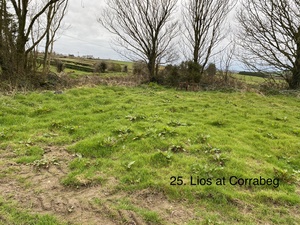
Lios: There is a ringfort (lios) in this townland. A ringfort is a circular fortified settlement that were mainly built during the Bronze age up to about the year 1000.
Cill: There is a disused children’s burial ground in this townland. These were used for children who died before they were baptised (as they could not be buried in consecrated ground). This is in the Cill field
Mass Rock: There was a Mass Rock in this townland. Mass was said here in penal times when it was banned. It is not known if this still exists
Two Lakes: Two lakes touch this townland. Loch na Lucharachán touches the northwest corner. This name can be interpreted as the lake of leprechauns or elves. It was said that dwarf-like things or fairies were seen there working like shoemakers . This is just a boggy area today. The other lake can be found at the northernmost point and is one of the twelve lakes of Aghills
Stream: There are two streams in this townland. One goes from Loch na Lucharachán to Aghills Lakes, bordering Currabeg and Letter, and is known locally as the Caol. It eventually connect to the other stream which is Caol a Dá Ghníomh (the stream of two gneeves). Caol a Dá Ghníomh divides the three townlands of Currabeg, Forenaght and Killangal.
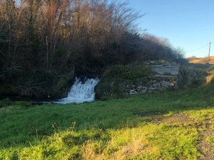
Waterfall: This can be seen on the side of the road between Droichead Uí Cnuasaigh and Bleaches Cross. This is known as Poll Radairí. Radhairí may refer to the name Rogers.or alternatively a person who rants and raves a lot.
Bridge: There is a bridge in this townland which is mapped as Currabeg Bridge. It is known locally as Droichead Uí Cnuasaigh. The unusual name Droichead Uí Cnuasaigh is thought to come from a nickname for a local branch of the O'Donovan family the "Uí Cnuasaigh". The name derives from Cnó (nuts) and Cnuasaigh is to gather nuts. There are still lots of hazelnut trees all along Caol a dá Ghníomh.
Flax Pond: It was said that there was a flax pond at the north of the townland
Bleacher's Cross: This is the boundary between Currabeg and Killahangil and is where the road from the N71 meets the road that runs from the Castlehaven creamery site towards Union Hall
, TheHistoric Environment Viewer has mapped the burial ground mentioned above
Interesting Placenames
Besides the places named above we have mapped the follow field-names in this townland: Páirc a' Leasa (field of the ringfort), Fair Field (fairs were held in this field in the 19th century), Smithy Forge (the local forge was at this spot), The Cill Field
If you want to see the actual location of any of these, go to detailed townland map on Open Street Maps. If you know any other field names or placenames in this townland (or if you need to correct any or give further background information), please contact us at [email protected]
Folklore
Draining of Lake: It is said that Loch na Lucharachán was drained by a landlord but he was unsuccessful. This may be why it is a bog today - it is marked as a marshy area in the 1841 map
Faction Fights: According to a story in the Castletownshend School's Collection, Currabeg fair usually ended in faction fights and in the last of these a man named Thomas Browne was killed. He may have been the last to die in a faction fight in the parish. Three families of the Brownes live in the parish, two in Killangil and one in Moneyvolihane
A Strange Sight: According to another story in the Tragumna Schools Collection called A Strange Sight, a farmer and his wife were riding home from Skibbereen to Currabeg late one night, As per the custom at the time, they rode on the one horse with the wife behind her husband. They reached a steep hill where it was said that a hound as large as a calf used to appear regularly. The wife was asking where the hound was when he appeared at the side of the road with his eyes flashing fire. The farmer spurred the horse and they gallopedall of the way home to Currabeg but the hound kept up with them all the way until they reached their house. The couple both lived to a ripe. old age and the farmer, Pat McCarthy, handed the story down in his family
Waterfall: It is said that when the sound of the waterfall in Currabeg (Poll Radairí.) can be heard in Killahangil, it is a sure sign of frost.
Bleach Cross: The Castletownshend School's Collection also mentions that Bleach Cross was also known as Bleache's Cross and that it was the site of the local forge. The stream here is the boundary between Currabeg and Killangil. The school's collection also mentioned th ata weaver lived here in the 19th century but he emigrated to the US with his entire family. There was also an old song that mentioned Currabeg but only one couplet is known:
Currabeg Hill our playground was
Our camp, the Bleache's Cross
Families and Notable Residents
The Tithe Applotment books of 1825 list the following family names: Hurley, Hurley, Hurley, Regan, Driscoll, Sanders
Griffiths Valuation of 1853 lists the following family names: Hurley, Hurley, Driscoll, Kohane, Hurley, Hurley, Brickley, Cadigan, Donovan, Driscol. Driscoll, Driscoll
The Census of Ireland of 1901 lists the following family names: Hurley, Driscoll, McCarthy, Hurley, Sullivan with Donovan (servant), McCarthy, Carey, Donovan
The Census of Ireland of 1911 lists the following family names: Carey, Sullivan, McCarthy, Hurley with Pigott (servant), Hurley, Wholey with O'Neill (mother-in-law) and Keating (apprentice), Cadogan with Driscoll (father-in-law and two sisters-in-law)
An article in Volume 16 of the Skibbereen Historical Journal suggests that Mary Hurley who was an aunt of world-famous singer, Denis O'Sullivan (1868-1908) was married in Currabeg
Note: the term 'with' refers to a person or persons of a different family name staying in the house. This may have been an in-law or other relative, a guest, or a farm labourer/housekeeper or domestic servant.
Demographics and Landholding
| *Occupiers | Population | Change | Link to record | ||
| 1825 | Tithe Applotment | 6 | 36 (est) | 1825 | |
| 1841 | Census of Ireland | 20 | 123 | ||
| 1851 | Census of Ireland | 13 | 89 | ||
| 1853 | Griffith's Valuation |
12 |
80 (est) | 1853 | |
| 1861 | Census of Ireland | 13 | 72 | ||
| 1871 | Census of Ireland | 12 (Incl. 1 unoccupied) | 59 | ||
| 1881 | Census of Ireland | 10 (Incl. 1 unoccupied) | 45 | ||
| 1891 | Census of Ireland | 10 | 41 | ||
| 1901 | Census of Ireland | 8 | 42 | 1901 | |
| 1911 | Census of Ireland | 7 | 35 | 1911 |
*Occupiers generally equate to households having a house and land but may also include households having houses but no land.
Between 1656 and 1658 the Down Survey mapped all areas of the country to track ownership of land after much had been granted to followers of Cromwell after the war of the 1650's. At this time the proprietors (titulados) of this townland were Donogh O'Donovan and Edmund Fitzgerald. The townland was part of Fiernogh & Garribegg at this time
The proprietor of this townland in 1841 was Colonel John Townsend of Castletownshend and his agent was Charles Clerke of Skibbereen. It was all held by tenants without a lease.
In 1841, the soil was described as middling, producing wheat, oats, potatoes and some flax
Images
Further Reading
-
Placenames Database of Ireland Logainm.ie entry for statutory version in Irish and English
- A Collection Of Placenames From Cork County, Barony Of West Carbery (East Div.),Volume 2 - Dr Éamon Lankford
- Castlehaven & Myross History Society Journal Vol. 1 - 2020
- Castlehaven & Myross History Society Journal Vol. 2 - 2021
- Castlehaven & Myross History Society Journal Vol. 3 - 2022 - The Whooley Blacksmiths - Jerome Geaney
- Skibbereen Historical Society Vol. 16 - 2020 - Pg 130 - The World-Famous Singer, Denis O'Sulllivan (1868-1908)
- Parish Histories and Place Names of West Cork - Bruno O'Donoghue
- Duchas: Schools Collection - Castletownshend - Currabeg Fair - Pg 210 & Pg 211
- Duchas: Schools Collection - Castletownshend - The Bleache's Cross - Pg 215
- Duchas: Schools Collection - Tragumna - A Strange Sight - Pg 53
- Sad Occurrence Near Skibbereen, Suicide at Currabeg, The Inquest - Southern Star - 22nd June 1895
- See townlands.ie for information on this townland
Links
Go to Homepage
Go to list of Townlands
Go to list of Irish words used locally
Go to local Flora and Fauna


