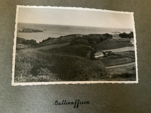
An Driseán or Drishane is a townland of 36 hectares or 89 acres and in the early part of the 20th century, 11 individual fields were mapped in this townland.
It is in the Electoral Division of Castlehaven North, in Civil Parish of Castlehaven and the Roman Catholic Parish of Castlehaven and Myross.
An Driseán is bordered by Baile an Chaisleáin (Castletownshend) to the east, and Fearann Dáith (Farrandau) and Cnoc Droma (Knockdrum) to the west.
OpenStreetmap contributors, with input from the Castlehaven & Myross History Society, have created a detailed townland map including all its minor placenames. Zoom in for further detail.
Etymology
An Driseán was interpreted by Bruno O'Donoghue as the place of briars or brambles. He also mentions that the north side is called Shanacluan which can be interpreted as Seana Cluain (old meadow) although this may be a sub-townland. In his 1913 article in the Southern Star, JM Burke agrees that driseán is the dimunitive of dreas, dris, a briar, a bramble. Eugene Daly also mentions this in his article in Volume 6 of the Skibbereen and District Historical Society Journal .
History
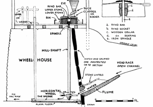
Mill: There are the ruins of an old mill in the valley. This was powered by a stream that drained the hinterland. On its way it passed by a house known locally as the Furzy Mill. This was the residence of the miller. The mill would appear to have had a horizontal wheel rather than the normal vertical one .Water was stored in a pond above the mill and the flow could be adjusted with a sluice gate. The illustration from another mill in the county should make this process easier to understand..Corn and oats from neighbouring farms would arrive along the old road that ran along the coast from Tragumna. However farm carts were not allowed to proceed any further due to a height discrepancy - possibly because the there a steep slope above the location of the mill.
Drishane House: It is the family home of the Somerville family and was built c. 1780 by Thomas Somerville, whose father (also called Thomas) had moved to Castlehaven and, as rector, lived in the castle at Castlehaven strand. It is famous for its hanging slate on the outside. It has fabulous views of Castlehaven Bay which allowed Thomas to keep an eye on the progress of his fleet of merchant ships. You can see further information on the Drishane House webite at https://drishane.com/welcome-to-drishane-house/ with information on its history at https://drishane.com/history/
Edith Somerville: She was probably the most famous resident of the townland. She became independently wealthy as a female writer which was very ununusal inthe late 19th and early 20th century. She wronte with her cousin, Violet Martin Ross..Check dib.ie
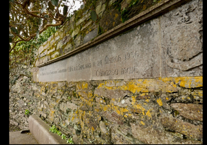
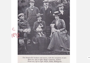
Monument to Admiral Boyle Somerville . On the 20th March 1936, Boyle Somerville (who was born in Drishane) was shot dead in his house in the village in the neighbouring townland of Castletownsend .It appears that it may have been a case of mistaken identity. The gunmen should have approached Drishane but local information led them to a different destination . Boyle was one of four brothers and two sisters and was born here in 1863. At 13 he joined the navy and worked his way up to Vice Admiral. He was a noted archeological scholar and is credited with the inception of archaeoastronomy. A monument was unveiled to him at the entrance to Drishane House.
Old Road: The old road from Castlehaven Strand to Castletownshend ran much closer to the coast than it did today and passed the site of the old mill. The
Old Creamery: A creamery was established c.1905 by the Somerville family of Drishane House on a site in the small section of Drishane townland which extends across the Coast Road, running along the boundary of the Drishane House Estate. The Skibbereen Eagle of 17/09/1910 contains an ad for the sale of complete creamery plant, including separator, churn, butter table etc. It would appear that rather than selling the plant and equipment, an arrangement was made that the creamery was taken over by Bradford, (probably in 1911), who was probably from Lissan, Co Tyrone – there was a creamery manager in Lissan in the 1911 census by the name of James Bradford. Records show that it closed in 1918 as it is not recorded in the Yearbook of 1919 of the Irish Creamery Managers' Association.
The Somerville family were the first in the south of Ireland to have the British Friesian breed of cattle and on starting the creamery they recruited a Galway lady who had trained at Ramsgrange in London as a Dairy Maid and subsequently listed as creamery manager in Bradford’s tenure. She was a Miss Delia Fahy, who met her future husband in Castletownshend and one of her best known grandchildren today is Paul O Driscoll from the Pound. Credit Source***
Bowling Road: There was a famous road-bowling road from Jim Barry's Cross to Castletownshend
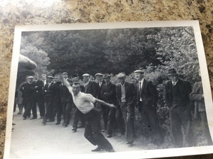 Jimmy Sheehy (Bawnishal) bowling at Drishane
Housing
As part of Griffiths Valuation in 1853, a survey of house quality was carried out to calculate what rates were due by each household. These were issued in 1850 in the form of house books and a guide on how to interpret these can be seen here. These show all 5 houses in the townland at that time were class 1. This means that they were slated and built with stone or brick and lime mortar. Four of the houses are described as medium (not new), but in sound order and good repair while the other house (Gate Lodge) is decribed as medium, slightly decayed, but in good repair. The class 1 houses are between 6 foot and 26 foot tall which indicates that some were single storey at this time.
By the 1901 census there were three occupied houses and all had walls of stone, brick or concrete with roofs of slate, iron or tiles. Two houses had two, three or four rooms with one having one window in front and the other having two (which indicates that they were probably still single storey) while the other house had thirteen or more rooms with twelve windows in front.
When we advance to the 1911 census there are now four occupied houses in this townland and all four have walls of stone, brick or concrete with roofs of slate, iron or tiles. Two houses had two, three or four rooms with one having two windows in front while the other one has three windows (which indicates that they were probably still single storey) while another house had five or six rooms with four windows in front. The final house had thirteen or more rooms with eleven windows in front.
Places of Interest
Gallán: There are two possible galláns (standing stones) in this townland. Standing Stones may have been boundary markers during the Bronze/Iron Age. Alternatively, they may have been commemorative monuments or may have been used to mark burial places.
Péicín Cnoc Droim Fionn: This is a peak and a ridge on the grounds of Drishane House. It can be interpreted as the small peak of the hill of Fionn's ridge. This is the location of the standing stones mentioned above
Poll Gorm: This is a cuas/pool that separates the townlands of Drishane and Farrandeligeen. The stream that provided water to the old mill runs into Poll Gorm.
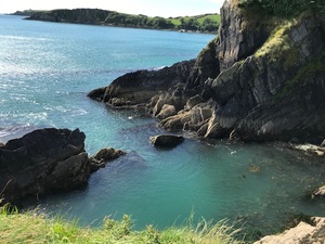 Poll Gorm - from Drishane side
Dutchman's Cove: This was named after two Dutch sailing ships that sunk approaching this spot. This cove was infamous for smuggling in the 18th and early 19th century as once you enter the cove, you cannot be seen from the open sea. There were hand-carved steps into the cliff from this strand to the fields above that acted as a transport route for the smugglers. These steps, although weathered, are still visible today.
View Halloa: This is a house on the coast road and got its name from a hunting term which was shouted by huntsmen when they spotted a fox breaking cover. This house was built for the Houndman, Mike Hurley, who minded the horses and dogs for the Drishane Hunt - he is shown in the photograph below
Furzy Mill: This is located on the coast road and is now derelict but was once the residence of the miller from the old mill mentioned above
Ball Alley: This is also located along the coast road and is still in existence. It had a front-wall and one side-wall. We are not sure what sport was played there
Creamery Cottage: This is also located along the coast road and is the name of the private house at the location of the old creamery mentioed above
There are a number of sites listed in this townland in the Historic Environment Viewer including the two standing stones mentioned above Cupmarked stones are listed in two other locations with one described as having eighteen cup-marks including a group of three which are conjoined and a pair, also conjoined. The other is decribed as being a large stone with twelve cupmarks on its upper surface. The stone rests on another large stone which is in turn supported by smaller pad stones. Mentioned elsewhere as a 'dolmen'.
Interesting Placenames
Besides the places mentioned above, we have also mapped the following field names in this townland: Salter's Field
The Coast Road/Western Road runs through this townland.
If you want to see the actual locations of any of these, go to detailed townland map on Open Street Maps. If you know any other field names or placenames in this townland (or if you need to correct any or give further background information), please contact us at [email protected]
Folklore
Ghosts?? ****
Families and Notable Residents
The Tithe Applotment books of 1825 list the following family names: Somerville, Salter, Attridge
Griffiths Valuation of 1853 lists the following family names: Somerville, Hegarty (Gate Lodge)
The Census of Ireland of 1901 lists the following family names: Somerville (with Martin (cousin) and 2 x Maguire (both servants)), Keppel, Dwyer
The Census of Ireland of 1911 lists the following family names: Somerville (with Martin (cousin) and Kirby, Keppel and Fahy (all servants)), Keppel, Dwyer, Goucher
Note: the term 'with' refers to a person or persons of a different family name staying in the house. This may have been an in-law or other relative, a guest, or a farm labourer/housekeeper or domestic servant.
Demographics and Landholding
| *Occupiers | Population | Change | Link to record | ||
| 1825 | Tithe Applotment | 3 | 18 (est) | 1825 | |
| 1841 | Census of Ireland | 3 | 18 | ||
| 1851 | Census of Ireland | 3 | 12 | ||
| 1853 | Griffith's Valuation |
1 |
4 (est) | 1853 | |
| 1861 | Census of Ireland | 4 (Incl. 1 unoccupied) | 18 | ||
| 1871 | Census of Ireland | 3 | 20 | ||
| 1881 | Census of Ireland | 3 | 22 | ||
| 1891 | Census of Ireland | 2 | 10 | ||
| 1901 | Census of Ireland | 3 | 16 | 1901 | |
| 1911 | Census of Ireland | 4 | 21 | 1911 |
*Occupiers generally equate to households having a house and land but may also include households having houses but no land.
Between 1656 and 1658 the Down Survey mapped all areas of the country to track ownership of land after much had been granted to followers of Cromwell after the war of the 1650's. At this time the proprietor (titulado) of this townland was Donogh McDermody. This townland was part of Sleughteige & Drishan at that time.
The proprietor of this townland in 1841 was the Arch Bishop of Dublin. It was all held under lease by Maurice Townsend of Shepperton and Henry Townsend of Castletownshend. It was sub-let by lease to Thomas Somerville of Castletownshend who held it as a demesne.
No description of soil quality in 1841 was listed.
Images
*****Get image of Drishane house
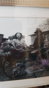 Edith Somerville in 1949 (the year she died) with her coach-man, Mike Hurley,and Nurse O'Riordan from Killarney
Further Reading
-
Placenames Database of Ireland Logainm.ie entry for statutory version in Irish and English
- A Collection Of Placenames From Cork County, Barony Of West Carbery (East Div.),Volume 2 - Dr Éamon Lankford
- Castlehaven & Myross History Society Journal Vol. 1 - 2020
- Castlehaven & Myross History Society Journal Vol. 2 - 2021
- Castlehaven & Myross History Society Journal Vol. 3 - 2022
- Skibbereen and District Historical Society Journal Vol 5 - 2009 - Half-conquered rebels: The big house and West Cork patriotism in Somerville and Ross's fiction (Padraig G. Lane) - Pg 1-7
- Skibbereen and District Historical Society Journal Vol. 6 - 2010 - The Influence of Trees on Place-Names in West Cork (Eugene Daly)- Pg 121
- Parish Histories and Place Names of West Cork - Bruno O'Donoghue
- Local Names - JM Burke (J.M.B) - Southern Star - 4th October 1913
- Drishane House - https://drishane.com/welcome-to-drishane-house/
- Drishane House history - https://drishane.com/history/
- See townlands.ie for information on this townland
Links
Go to Homepage
Go to list of Townlands
Go to list of Irish words used locally
Go to local Flora and Fauna

