Carraig Tí Seáin or Carrigtishane is a townland of 31 hectares or 77 acres and in the early part of the 20th century, 24 individual fields were mapped in this townland.
It is in the Electoral Division of Castlehaven North, in Civil Parish of Castlehaven and the Roman Catholic Parish of Castlehaven and Myross.
Carraig Tí Seáin is bordered by Baile an Chaisleáin (Castletownshend) to the east, Fornocht (Forenaght) to the north and Cill Achaidh Aingle (Killangal) to the west
OpenStreetmap contributors, with input from the Castlehaven & Myross History Society, have created a detailed townland map including all its minor placenames. Zoom in for further detail.
Etymology
Carraig Tí Seáin was interpreted by both Bruno O'Donoghue and J.M. Burke as the rock of John's house (Carraig Tighe Sheáin). Burke gives an alternative interpretation in his 1913 Southern Star article as Carraig Tighe Siodháin which would be the rock of the house on the fairy knoll.
Rinneen was a village located in this townland and was interpreted by JM Burke as the little point of the sea.
History
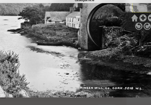
Rineen: There was a village in this area in the past when the mill was in operation. The picture of the mill below was taken from the William Lawrence Collection
Shops: Rineen was once an industrious village with a mill, a creamery, two shops and also a couple of post-offices. John William Connell tended a small but beautifully proportioned shop in the centre of Rineen. The local Catholic priest resided here until the 1930s. An idyllic scene of ‘lighters’ navigating up the bay with the rising tide the only sound, an oar plunging into the shallow water like gondoliers of faraway Venice. Like all small shops he sold all the basic goods including flour, (no flower selling in those days) and was licensed to sell tobacco. Early on there was even a miniature post office operating, though not competing with the post office further west under the road in the same townland. Many times as he tended to his animals or garden, a sign displayed ‘back in half an hour’, but there was no need to wait as he was always close by. The paper left by the downpipe, the penny bars, all lost and gone forever. One customer even rowed across the quagmire in a punt for his pound of butter. The shop proprietor even made an appearance with the local football club.
A whistle hung outside the door and the display note read, ’If you need assistance blow the whistle, if you are in a hurry, blow twice’. In today’s world he would perennially win Shopkeeper of the Year.
Other shops operated here as well, including a shop attached to the Cork and Kerry Creamery. This operated close to the entrance to Goods Mill, closing in March 1946. The Harnedy house at the end of the village had shop credentials (home with one room dedicated to selling some goods) run by the war widow of Micheal O’Brien.
The big house of the Good family, built around 1932 also had a shop within the house. One shop assistant with the name of Harte waited for the postman, William Connell, eventually marrying and opening the shop across the road which will always be known as John William's
Mill: The first bolting factory in Carbery was built here in 1780.. There was a water-driven corn-mill in this townland between 1780 and 1820. The water came from Caol a dá Ghníomh (stream of two gneeves) which, in turn, has its source in Shepperton Lake. They used to dam the stream at Currabeg Bridge. At the time of Griffiths Valuation, the Landed Estates section of the UCG website stated thatthe mill was held by Messers. Swanton, Goold and McNamara and was valued at £56. Another reference suggests that there may have been a mill at this location since 1679 and may once have been in the ownership of a Robert Triphook./Tripbrook. The mill buildings are now disused but are still standing. It is described as follows in the National Inventory of Architectural Heritage - Freestanding L-plan mill complex, built c.1800, comprising central three-bay five-storey block with two-bay five-storey pitched roof block to front (north) with attic storey, double-pile two-storey two-bay addition to rear (south) with attic storey, remains of two-storey gable-fronted additional blocks to west and more recent corrugated-iron extensions to north-east. Now disused. Pitched slate roofs to main blocks having red brick chimneystacks to double-pile block. Remains of cast-iron rainwater goods to main blocks. Rubble stone walls throughout main blocks with slate hanging to side returns of northern block. Square-headed window and loading bay openings throughout structure having stone sills, voussoirs to arches and various replacement timber framed windows. Battened timber shutters to loading bays with remains of lifting equipment to north elevation of projecting block. Square and camber-headed door openings with stone voussoirs, timber frames and remains of battened timber doors. Located on the southern bank of a small river with a concrete quayside having stone slab steps
They added an appraisal as follows: An extensive mill complex, which though now disused, is an important reminder of the industrial heritage of the Rinneen area. It was operated for a time by the Swanton family, who were well known Methodists in the area. The retention of original features such as slate hanging, timber sash windows, loading-bays and their associated equipment makes this a building of importance. Set in a tidal inlet, its produce could be loaded directly into boats and taken to far flung markets.
The final owner of the mill was Ronnie Good. He had a reputation as a good employer and there was a local saying that "God is good but Good is better".
Creamery: There was a creamery in this townland in the past. It would have been one of many in the parish at that time but they generally closed as the Drinagh Co-Op took over. In his article in Volume 1 of our journal, Jerome Geaney wrote the following: Records show that a creamery was extablished in Keelahangil townland beside Rineen Crossroads in 1894 by a local farmer W.T. Bennett. It was taken over c.1899 by the C & K Creamery Company, (Cork and Kerry) which had recently purchased the failed Co-Op creamery in Skibbereen. Rineen was acquired by the D.D.C. (Dairy Disposal Compan ) as part of its overall purchase of the C &K Company in 1945 and closed with its milk supply transferred to Drinagh Co-Op (Raheen) and to Lisavaird Co-Op (Myross).
Rineen House: Information locally suggests that James Swanton built this house althoughit seems to be stated in Griffiths Valuation of the 1850s that he was leasing the house from Rev. M. Townshend. The house was later used by the Catholic Church as the parish priest's house until he moved to Castletownshend. Rinneen House is now a ruin which was offered for sale in 2009.
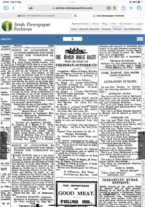
Rineen Races: These started in around 1909 and ran for a few years before disbanding. There was a Pensioners Race in 1911 (the Old-Age Pension was introduced in 1909) and it was won by Mr. J. Tobin (who may have been the creamery manager while Mr. D. Holland was a "good second". The races were revived for a short period around 1945 and again around 1989. The route took in Killangal (going up the High Road, down Fitz's Boreen and back the main road to Rineen)
Housing
As part of Griffiths Valuation in 1853, a survey of house quality was carried out to calculate what rates were due by each household. These were issued in 1850 in the form of house books (Pg 1, Pg 2) and a guide on how to interpret these can be seen here. These show that 10 of the 11 houses in the townland at the time were class 3. This means that they were all thatched houses with stone walls with mud or puddle mortar. Within class 3 there are a number of different categories. 9 of these houses are old (more than 25 years old) but out of repair while two are described as old and dilapidated, scarcely habitable. The other house in this townland at this time is class 1 which means that it was slated and built with stone or brick and lime mortar - it was described as medium (not new), but in sound order and in good repair. All of the class 3 houses in the townland at this time are between 4 foot 6 inches (!) and 6 foot 3 inches tall which indicates that they are single storey at this time. The class 1 house is listed as being 9 foot tall..
By the 1901 census, there are 6 occupied houses in this townland at this time (as well as a Corn Mill) and all have walls of stone, brick or concrete with roofs of slate, iron or tiles. Three houses have two, three or four rooms with two having two windows in front (probably still single storey at this time) while the other has no windows listed. Two houses are listed as having seven, eight or nine rooms and four and six windows in front respectively. The remaining house has more than thirteen rooms with sixteen windows in front.
When we advance to the 1911 census there are 7 occupied houses in this townland and, not surprisingly, all still have walls of stone, brick or concrete with roofs of slate, iron or tiles . Four houses have two, three or four rooms with three having two windows in front (probably still single storey at this time) while the other has three windows in front. Two houses are listed as having seven, eight or nine rooms with four and six windows in front respectively. The remaining house has ten, eleven or twelve rooms with twelve windows in front.
Places of Interest
Cill: There is a disused children’s burial ground in this townland. These were used for children who died before they were baptised (as they could not be buried in consecrated ground). This cill was accessed from the side of the lakes in Castletownshend townland. It was used up to about 1940
Factory Hill: The road through the townland is known as The High Road but there is a short hill that is known as Factory Hill (after the mills in this townland)
The mill and the children's burial ground mentioned above are both mapped on the Historic Environment Viewer
Interesting Placenames
There is a road known as The High Road that runs through this townland.
No field names or any other placenames have been recorded for this townland. If you are aware of any, please contact us at please contact us at [email protected].
Folklore
There is a story in the Castletownshend School's Collection about a couple known as Biddy and Jerh (pronounced Jer) who were husband and wife and lived in a little house near the entrance gate to Rinneen House. When the owner of the house went in or out with his horses and carriage either Biddy or Jerh went to open the gate and they often got a few pence when visitors came. Biddy was a good humoured woman who used to say a lot to amuse the visitors and as a result she always got more money than Jerh when she went to open or close the gate. She never wore shoes except when going to Mass or to town One day a very "swanky" crowd arrived in a carriage at the gate. Being barefoot she was afraid the strangers would not like her so she said to Jerh, "Run out and open the gate, Jerh, as you have the shoes". Jerh's reply was "Let you run out, Biddy, as you have the tongue".
Families and Notable Residents
The Tithe Applotment books of 1825 list the following family names: This townland is not listed on the Tithe Applotments
Griffiths Valuation of 1853 lists the following family names: Swanton, Murphy, Kelly, Neale, Connolly, Herlihy, Sullivan, Swanton, Swanton. In addition, the following families had land only: Fitzgerald, Rev. Townsend (plantation). Also there was a flour mill here that was leased to Goold, McNamara and Swanton
The Census of Ireland of 1901 lists the following family names: Collins, Regan, Kearney (with Norris, Hegarty and Hurley (all servants)), Barry, Burchill, Good
The Census of Ireland of 1911 lists the following family names: Collins, Hayes, Regan, Hennessy (with Crowley, McCarthy and Collins (all servants)), Good (with Moore (boarder) and Gorman (servant)), Choafe (? - Corn Miiller), Driscoll
Note: the term 'with' refers to a person or persons of a different family name staying in the house. This may have been an in-law or other relative, a guest, or a farm labourer/housekeeper or domestic servant.
Demographics and Landholding
| *Occupiers | Population | Change | Link to record | ||
| 1825 | Tithe Applotment | ? | ? | Not mentioned | |
| 1841 | Census of Ireland | 0 | 0 | ||
| 1851 | Census of Ireland | 12 (Incl. 1 unoccupied) | 76 | ||
| 1853 | Griffith's Valuation |
10 |
70 (est) | 1853 | |
| 1861 | Census of Ireland | 11 | 70 | ||
| 1871 | Census of Ireland | 8 (Incl. 1 unoccupied) | 31 | ||
| 1881 | Census of Ireland | 6 (Incl. 1 unoccupied) | 31 | ||
| 1891 | Census of Ireland | 3 | 34 | ||
| 1901 | Census of Ireland | 8 (Incl. 2 unoccupied) | 22 | 1901 | |
| 1911 | Census of Ireland | 8 (Incl 1 unoccupied) | 24 | 1911 |
*Occupiers generally equate to households having a house and land but may also include households having houses but no land.
Between 1656 and 1658 the Down Survey mapped all areas of the country to track ownership of land after much had been granted to followers of Cromwell after the war of the 1650's. The most prominent proprietor (titulado) of this townland at that time was Donnall Callahane. This townland was know as Sleughteige & Kiltangly at that time.
The proprietor of this townland in 1841 was Colonel John Townsend of Castletownshend and his agent was Charles Clarke of Skibbereen. It was all in one let.
In 1841, the soil on the eastern side of the townland was decribed as coarse while the western part was pretty good.
Images
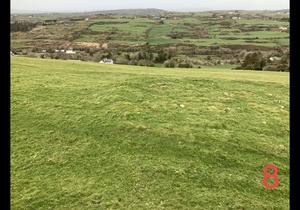 Location of cill (children's graveyard)
Further Reading
-
Placenames Database of Ireland Logainm.ie entry for statutory version in Irish and English
- A Collection Of Placenames From Cork County, Barony Of West Carbery (East Div.),Volume 2 - Dr Éamon Lankford
- Castlehaven & Myross History Society Journal Vol. 1 - 2020 - Dairying in Castlehaven - Jerome Geaney Pgs 129-136
- Castlehaven & Myross History Society Journal Vol. 2 - 2021
- Castlehaven & Myross History Society Journal Vol. 3 - 2022
- Dúchas.ie - Schools Collection - Baile an Chaisleáin - Pg 259 -Biddy & Jerh
- National Inventory of Architectural Heritage - https://www.buildingsofireland.ie/buildings-search/building/20914258/rinneen-mills-carrigtishane-county-cork
- Landed Estates - https://landedestates.ie/property/2528
- Three Promontory Forts in Co. Cork - Michael J. O'Kelly, John T. Collins, P. O'Connor, A.W. Stelfox, G.Roche and G.A. Hayes-McCoy
- Parish Histories and Place Names of West Cork - Bruno O'Donoghue
- Local Names - JM Burke (J.M.B) - Southern Star - 4th October 1913
- See townlands.ie for information on this townland
Links
Go to Homepage
Go to list of Townlands
Go to list of Irish words used locally
Go to local Flora and Fauna

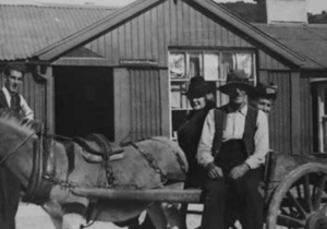
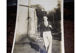
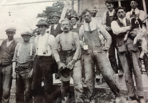 Workers at Rinneen House