Geocán or Gokane is a townland of 77 hectares or 191 acres and in the early part of the 20th century, 66 individual fields were mapped in this townland.
It is in the Electoral Division of Castlehaven South, in Civil Parish of Castlehaven and the Roman Catholic Parish of Castlehaven and Myross.
Geocán is bordered by An Bán Leathan (Bawnlahan) to the north and Rinn Dá Chosán (Reendacussane) to the east
OpenStreetmap contributors, with input from the Castlehaven & Myross History Society, have created a detailed townland map including all its minor placenames. Zoom in for further detail.
Etymology
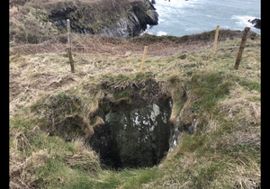
Geocán (locally pronounced 'Yeo-kawn' and sometimes written as Yokane) was interpreted by Bruno O'Donoghue as a neck of land. Geocán can also mean a windpipe so it is possible that this may refer to what appears to be a man-made shaft or perhaps to the geographical feature known as a blowhole which is found at the end of the peninsula.
History
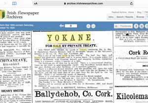
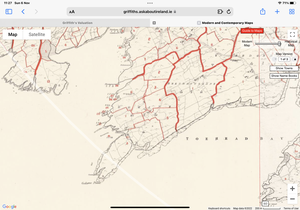
Farm Sale: A farm for sale in 1924 makes for interesting reading. The creamery mentioned was on Richard Hurley’s property of Stags View while the school was in Tragumna. Seaweed rights are well defined: the purchaser was entitled to collect seaweed on the first three days of the week from October to April and the second three days of the week from April to October. The vendor was Richard Barnett who moved to Dooneen. The Griffiths Valuation map of c 1852 includes all the islands visible at low tide. The seaweed from these islands may have been subject to a fee. A long handled scythe known as a scouedri or a corran cam was used for harvesting. Seaweed and sand were very important as fertiliser. Land with access to the beach carried a higher valuation. Of note also is the ‘island ‘ which was formerly joined to the mainland. Now the tide flows freely around it. The farm made £700 pounds at auction.
Illegal Creamery: In July 1930, three dairy farmers were bought before the courts in relation to organising and supporting an illegal creamery in Bawnishal. Drinagh Co-op had a branch at Raheen Cross and all farmers were to bring their milk to this creamery. However the time taken in travelling up to 6 miles each morning aggrieved the farmers. The Gokane ‘ law breakers ‘ were Patrick Coughlan, Tim Murphy and Denis Driscoll. A full report is published in The Southern Star of 26th July 1930
Shipwrecks: There is evidence of two shipwrecks at Gokane Point. In 1883, a brig named the Saga foundered but was salvaged. The Carnarvonshire was not as lucky and lies a half a kilometre east, off Gokane Point. This was a beautiful three-masted ship built in Liverpool in 1876. On her final voyage, she was bound from San Francisco to Cobh (Queenstown) with a cargo of wheat. On that fateful day of April 11th 1896, she struck rocks and now lies 20 metres below the surface. Thankfully after striking Thige Mór Rock, Captain Williams and his crew of twenty were able to row ashore to Traligagh. As the wreck is more than a century old, a permit is needed to dive..
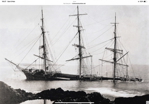 Photo may be taken at the rock pools at Gokane
Housing
As part of Griffiths Valuation in 1853, a survey of house quality was carried out to calculate what rates were due by each household. These were issued in 1850 in the form of house books and a guide on how to interpret these can be seen here. These show that 10 of the 12 houses in the townland at that time were class 3. This means that they were thatched houses with stone walls with mud or puddle mortar. Six are described as being old (more than 25 years) and in repair while the other four are old but out of repair. The other two houses in Gokane at this time are class 1 which means that they were slated and built with stone or brick and lime mortar - one is described as being medium (not new), but in sound order and good repair while the other is medium, slightly decayed, but in good repair. All houses in the townland at this time are between 5 foot 6 inches (!) and 8 foot tall which indicates that most are single storey at this time.
By the 1901 census,there are now seven occupied houses in this townland but all have walls of stone, brick or concrete. Six have roofs of slate, iron or tiles while the other is still thatched. All have two, three or four rooms.. Four houses have two windows in front (indicating that they are probably still single storey at this time) while the other three houses have five windows in front (probably two storey).
When we advance to the 1911 census there are still 7 occupied houses in this townland and, not surprisingly, all have walls of stone, brick or concrete. All seven houses now have roofs of slate, iron or tiles. All seven still have two, three or four rooms. Strangely two houses are now listed as having just one window in front while two others have two windows. As before, three houses have five windows in front.
Places of Interest
Thatched Cottages: Why build thatched cottages in such an ‘áit iargúlta’ or out of the way place as Gokane? The answer lies in the era of the Cold War, a fallout from WW2. Switzerland was afraid of a Russian invasion with the possible use of nuclear warheads. So operation ‘Stay Behind’ was born. This would protect the government with a safe haven and West Cork was chosen. Enter Colonel Albert Bachmann who was, by now, leader of the Buro Hä (a private intelligence agency that carried out work for the Swiss Government). Bachmann was extremely interested in horses and settled in West Cork, building a house on the coast between Squince and Carrigillihy. Local builder John O'Mahony of Forenaught built four holiday houses in Gokane in 1972 and The Skibbereen Eagle Pub in 1977. The plot thickens.
While the holiday houses were rented to tourists with an interest in fishing and boating, it was widely believed that this was a cover for the training of Swiss intelligence agents. Colonel Bachmann was well known in the area, especially among horse enthusiasts and had assembled some beautiful carriages for festivals and shows. In 1977 Lissard estate became available and was bought for £70000 including 140 acres of land ,wood and lake. Bachmann sold the cottages in Gokane and turned the house into a classy hotel, serving both the local and international tourist. At times the hotel closed for brief periods to facilitate meeting and training for Swiss intelligence. A sophisticated communication system wasxinstallled as was a huge oil tank at the rear of the hotel. This was to facilitate the workings of a generator in the event of a power outage. The story ends here as Russia never invaded Switzerland.
Mine Shafts: There are a number of shafts to be found in this townland which may be associated with former mines. Slate was excavated from the shaft . These were small in size. This slate quarry was owned by the Barnett family. Drinagh Coop or Fuller’s had an interest. During the War of Independence, Bernie O'Driscoll, who was on the run, spent a period of time holed up in one of the deeper shafts. During that time, he was fed by local people who kept his whereabouts secret.
Denis Mór O Driscoll fished out of here and collected seaweed as well. The long ‘strap wrack’ was harvested for use in growing mangolds. Apparently the straps were laid along the ridges and became a weed deterrent as well.An unwritten law of seaweed collection was if you put it in a heap then no one else could claim it.
Cill: There was a children’s burial ground in this townland. These were used for children who died before they were baptised (as they weren't permitted to be buried in consecrated ground).
The Historic Environment Viewer mentions the children's graveyard mentioned above.
Interesting Placenames
Besides the places named above we have mapped the follow field-names in this townland: Zaavdoordyke (this is reported by Lankford but would be strange - may be a family name rather than a field name).
There are also a number of coastal features in this townland. These would be as follows: Cuas na gCleití (cove of the feathers), Cuas na gColúr (cove of the pigeons), Gokane Point, Cuas na mBárc (possibly cove of the ships). Is Coosnasraithí in this townland. What does it mean *****
The coast road runs through this townland and there is a track known as the Bóithrín
If you want to see the actual location of any of these, go to detailed townland map on Open Street Maps. If you know any other field names or placenames in this townland (or if you need to correct any or give further background information), please contact us at [email protected]
Folklore
We have no folklore for this townland at present. If you are aware of any, please contact us at [email protected].
Families and Notable Residents
The Tithe Applotment books of 1825 list the following family names: Barra (possibly Burns), Dwyer, Driscoll, Burns (?)
Griffiths Valuation of 1853 lists the following family names: Murphy, McCarthy, Murphy, Driscoll, Murphy, Driscoll, Dwyer, Sullivan, Murphy, Murphy, Connolly.
The Census of Ireland of 1901 lists the following family names: Sullivan (with Murphy - mother-in-law), Murphy, Burns, Murphy, Driscoll, Dwyer, Driscoll
The Census of Ireland of 1911 lists the following family names: Sullivan, Murphy, Murphy, Driscoll, Driscoll (with McCarthy - grand-daughter), Driscoll (with Coughlan - nephew), Dwyer
Note: the term 'with' refers to a person or persons of a different family name staying in the house. This may have been an in-law or other relative, a guest, or a farm labourer/housekeeper or domestic servant.
Demographics and Landholding
| *Occupiers | Population | Change | Link to record | ||
| 1825 | Tithe Applotment | 5 | 30 (est) | 1825 | |
| 1841 | Census of Ireland | 14 | 88 | ||
| 1851 | Census of Ireland | 12 | 78 | ||
| 1853 | Griffith's Valuation |
11 |
66 (est) | 1853 | |
| 1861 | Census of Ireland | 12 | 70 | ||
| 1871 | Census of Ireland | 9 | 49 | ||
| 1881 | Census of Ireland | 9 | 57 | ||
| 1891 | Census of Ireland | 8 | 57 | ||
| 1901 | Census of Ireland | 7 | 47 | 1901 | |
| 1911 | Census of Ireland | 7 | 28 | 1911 |
*Occupiers generally equate to households having a house and land but may also include households having houses but no land.
Between 1656 and 1658 the Down Survey mapped all areas of the country to track ownership of land after much had been granted to followers of Cromwell after the war of the 1650's. The most prominent proprietor (titulado) of this townland at that time was Donogh O'Driscoll (alias Carragh). This townland was called Yockan at that time.
The proprietors of this townland in 1841 were Rev. Michael A Becher of Mallow and John Thomas Becher of England. It was all held under lease by Thomas Somerville of Drishane, Castletownshend and sub-let to tenants without a lease.
In 1841, the soil was described as 2/3 coarse and 1/3 arable, producing light crops of wheat, oats and potatoes.
Images
<div> 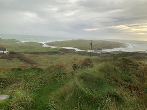 Geocán ar lá stoirmiúil</div> <div> </div>
<div> </div>
Further Reading
-
Parish Histories and Placenames of West Cork - Bruno O'Donoghue
-
Placenames Database of Ireland Logainm.ie entry for statutory version in Irish and English
- A Collection Of Placenames From Cork County, Barony Of West Carbery (East Div.),Volume 2 - Dr Éamon Lankford
- Castlehaven & Myross History Society Journal Vol. 1 - 2020
- Castlehaven & Myross History Society Journal Vol. 2 - 2021
- Castlehaven & Myross History Society Journal Vol. 3 - 2022
- Parish Histories and Place Names of West Cork - Bruno O'Donoghue
- Forty Farmers Prosecuted: Important Creamery Act Case - Southern Star, 26th July 1930
- See townlands.ie for information on this townland
- Wreck of Carnavonshire - http://www.irishwrecksonline.net/details/Carnavonshire124.htm
- Skibbereen and District Historical Society Journal ,Volume 6 ,(2010),( pages 82-88)
Links
Go to Homepage
Go to list of Townlands
Go to list of Irish words used locally
Go to local Flora and Fauna

