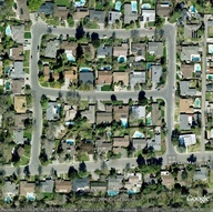
 Rancho Macero in South Davis
Rancho Macero is a South Davis neighborhood, located North of Willowbank and due East of Woodbridge. One must pass through it via San Marino Drive to get to half of Woodbridge by car; the other half of Woodbridge is accessible only via La Paz Drive in the nominal neighborhood of West El Macero. Rancho Macero's street plan is a square bisected horizontally by La Canada Way.
The southern edge of the square (and the only entrance by car from Mace Boulevard) is San Marino Drive, the eastern edge of the square is Santa Paula Way, the northern edge of the square is San Ramon Drive, the western edge of the square is Sierra Madre Way. San Marino Drive once dead-ended just past Sierra Madre Way, but this was later turned into the eastern terminus of the Putah Creek Bike Path. The Ricci Farm, which the bike path bordered, was sold and developed as Woodbridge. Consequently, San Marino Drive ceased to be a dead end and became one of two entrances to the new development and the bike path was slightly re-routed to accommodate this.
There is also an alley that provides access to rear-situated garages for houses on both the west side of Mace Boulevard and houses on the east side of Santa Paula Way. The alley opens onto San Marino Drive as one enters Rancho Macero to their immediate right. A small paved drive connects the other end of the alley with Santa Paula Way, just near 812 Santa Paula Way. Neighborhood children sometimes referred to the alley as Dead Cat Alley. 1
Footnotes
1. There is a real Dead Cat Alley in Woodland. It even has a law office at 666 Dead Cat Alley.


Comments:
You must be logged in to comment on this page. Please log in.