Carraig Oilche or Carrigillihy is a townland of 112 hectares / 276 acres and in the early part of the 20th century, 120 individual fields were mapped in this townland.
It is in the Electoral Division of Myross, in Civil Parish of Myross and the Roman Catholic Parish of Castlehaven and Myross.
Carraig Oilche is bordered by Ardráth (Ardra) and An Chathair Gheal (Cahergal) to the west and An Sceachánach (Skahanagh) to the north.
OpenStreetmap contributors, with input from the Castlehaven & Myross History Society, have created a detailed townland map including all its minor placenames. Zoom in for further detail.
Etymology
Carraig Oilche can be interpreted as a rock that is hidden . Bruno O'Donoghue gave it as Carraig Uilligthe and interpreted it as an angular or corner rock. In 1916, J. M. Burke gave it as Carraig Oillighthe and also interpreted it as a hidden rock.
Many attempts were made by early English settlers to anglicise Carraig Oilche. These included Carrigillyie in 1601, the O'Donovan c. 1625 grant listed Carrigillihie, Smith gave it as Carigiliky in 1750 while Bath gave Killcarrigelly in 1811. The Ordnance Survey standardised these attempts c. 1841 with Carrigillihy.
Today, the Placenames Database of Ireland lists the original Carraig Oilche and the anglicised Carrigillihy as the statutory spellings. Either version can be used as a postal address or for legal and other documents.
Local pronunciation of Carrigillihy ranges from 'carraigella' to 'carraigeilithe', Both versions still largely follow the original Irish sound.
There was a sub-townland here that was known as Liath Óileán (grey island). It is not an island and it is said that the stone looks grey on a sunny day
History
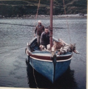
Village: Carrigillihy was one of three villages in the parish in the 1841 census and the village had 168 inhabitants (82 male and 86 female) in 35 houses. Prior to the famine, Carrigillihy was clearly a thriving fishing community with a very definite village centred close to the strand. At the time of the 1841 census, a fishing village had become so well-established that its population was recorded separately from the surrounding townland. The famine appears to have had a devastating impact, however, though it is unclear whether the collapse in population is attributable to starvation, disease or emigration (or a combination of all three) or, indeed, whether clearance (eviction) was a factor. Whatever the reason, between 1841 and 1851, the village had disappeared off the face of the earth and in 1851 , what remained was no longer being classified as a village. Those who survived and hadn't emigrated appear to have moved into nearby Union Hall (as evidenced by the growth in population there) or into the Auxilary Workhouse (that was established in Union Hall). It should be noted that at the time of Griffith's Valuation in 1853, Richard Kingston appears to have been the only holder of a lease in the townland of Carrigilllihy. All other occupiers had houses but were landless. The 1901 census records most adult males as either fishermen or agricultural labourers (not farmers) indicating that none of the occupiers farmed their own land at that time. This remained the case in 1911. The Kingstons, who held the lease on the land (or had perhaps taken ownership of it from William French), were not resident in 1901 but had become resident by 1911. This appears to have come about as Richard Kingston had been married in about 1902 and had taken up residence at that time. The Kingstons were Methodists (as was their children's governess, Margaret Lauder, who was from Co. Armagh). All other residents of Carrigillihy were Catholic.
Famine: The book, The Famine Story" lists the men from this townland that were working on the Myross Relief Scheme on 28th August 1846 during the Great Famine. These were public works that involved hard labour for a low wage for a workforce that were already weak and starving. The names were as follows: Jeremiah Carty, Cornelius Neal, Denis Walsh, Denis Hennessy, John Leary, Jeremiah Murray, Timothy Driscoll, Jerry Wholey, Daniel Horan, Timothy Meenig, Cornelius Donovan, Jeremiah Donovan, Michael Donovan, James Sullivan, Daniel Donovan, Charles Glaveen, Michael Greaney, Denis Greaney (Greany), Denis Donovan, Timothy Donovan, Pat Hegarty, Tim Sullivan, Cornelius Callaghan, Richard Meenig, James Tobin, Jeremiah Driscoll, Morgan Donovan, Denis Glavin, Jeremiah Murray, Cornelius Greany, Michael Sullivan, Daniel Donovan, William Casey, Daniel Horen, Richard Walsh, Patrick Collins, Cornelius Hegarty, Timothy Driscoll, Jerry Donovan, Daniel Leary, John Collins, Pat Collins, Jeremiah Greany, Jer Sullivan, John Murray, Daniel Greany, Cors Hegarty, Jeremiah Daly, Andres Carthy, Timothy Donovan, Cornelius Greany, Daniel Greany, Daniel Collins, John Collins, Jerry Hegarty, Timothy Donovan, Denis Glaveen, William Sullivan (?), Cornelius Donovan, Timothy Hegarty, Jerry Driscoll, Michael Walsh
Promontory Fort: A promontory fort was excavated in the 1950s but little of interest was found. Not mapped
Monastery: There is an ancient abbey in this townland which was called the Sancto Mauro which was founded around AD 1172 by Dermod McCormac McCarthy,King of Desmond, for Cistercian monks. The outline can still can seen. An alternate name was Fonte Vivo (clear spring). It is mentioned in Jim Byrne's article in Volume 9 of the Skibbereen and District Historical Society Journal . Not mapped
According to local knowledge there was a souterrain leading from the monastery to the sea.
The Loss of the Annie B in 1903: On the 28th November 1903, a fishing boat, the Annie B, was hit by a sudden squall between High Island and Myross Island. Three fishermen were lost and two survived the tragedy. This was devastating for the community at that time. A full account of the tragedy can be read here: Drowning at Myross 1903 (failteromhat.com).
One hundred years later, grandchildren of the crew of the Annie B commemorated the event and unveiled a plaque on Carrigillihy strand.
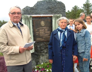 Unveiling the memorial of the Annie B
Housing
As part of Griffiths Valuation in 1852, a survey of house quality was carried out to calculate what rates were due by each household. These were issued in the form of house books (Pg 1, Pg 2) and a guide on how to interpret these can be seen here. These show that five of the ten occupied houses in the townland at that time were class 3. This means that they were thatched houses with stone walls with mud or puddle mortar. All five of these were described as old (more than 25 years) with two being in repair and three being out of repair. The remaining five houses were class 1 which meant that they were slated dwelling houses with stone or brick and lime mortar. One of these was described as medium (not new) but in sound order and good repair while another two are described as medium, deteriorated by age and not in perfect repair. The other two class 1 houses are old (more than 25 years) with both being in repair. All of the class 3 houses in the townland at this time are between 6 and 7 feet tall which indicates that they are single storey at this time. The class 1 houses are between 7 foot and 15 foot 6 inches tall respectively.
By the 1901 census there are now just 9 occupied houses and all have walls of stone, brick or concrete. Eight have a roof of slate, iron or tiles while the other one is still thatched. One house has just one room with two windows in front while another six houses have two, three or four rooms with one of these having no window in front, one having just one window while the other four have two windows in front (which indicate that they are probably still single storey at this time). The remaining two houses have two, three or four rooms with three windows in front.
When we advance to the 1911 census there are just 8 occupied houses and, not surprisingly, all still have walls of stone, brick or concrete. Seven have a roof of slate, iron or tiles while the other one is still thatched. Seven of the eight houses have two, three or four rooms with one of these still having no window in front, four having two windows in front (which indicate that they are probably still single storey at this time) and two houses having three windows in front. The remaining house has seven, eight or nine rooms with five windows in front.
Places of Interest
Lios: There were two ringforts (liosanna) in this townland. One can still be seen. Ringforts are circular fortified settlements that were mainly built during the Bronze age up to about the year 1000.
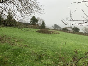
Cill: There are two cillíní (disused children’s burial grounds) in this townland. These were used for children who died before they were baptised (as they could not be buried in consecrated ground). According to local information the children's burial ground to the west of Carrigilihy Bay is known as Cill na Leanbh. Traces of low mounds indicate the graves. This cill is located in a pasture, on a terrace on a north-facing slope and is enclosed by the intermittent remains of an earthen bank (width 1m; height 0.2m). The above description is derived from the published 'Archaeological Inventory of County Cork. Volume 1: West Cork' (Dublin: Stationery Office, 1992). One of the last babies to be buried there was baby Mary Glanton who was born and died in 1930.
It is thought that the other one was located in the old Cistercian abbey in the north-east corner of the townland (mentioned above).There are no remaining traces of the abbey.
Rocks: The distinctive rock, to the east of Rabbit Island as one looks out from Carrigillihy strand, is known as the Stáca. It was probably originally known as An Stáca na mBeann - beann or ben meaning peak. There is also a rock in Carrigillihy Harbour known as Síle Rabh (Sheila Point) - a rabh is a dangerous reef. These were mapped on British War Office map as Sheela's Rock but they are known locally as Síle Rabh.
Coastal Promontory Fort: There is also a stone fort at the eastern side of the townland, overlooking Glandore harbour.
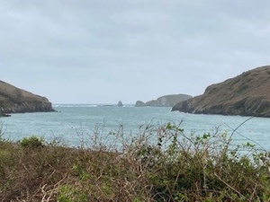
Harbour: Carrigillihy Bay is in this townland
Mass Path: As there was a very poor road system, people travelled over the hill to go to Myross. There may have been a mass path here
Holy Well: There is a well in this townland known as Tobar na Cille (well of the children's graveyard). It is a holy well of irregular shape said to be associated with the cill to the southwest. It is located in the field known as The Cill). Water emerges from the cliff-face.
Interesting Placenames
There is a point at the edge of Carraigillihy Harbour known as Pointe an Dorais (point of the door)
There is an area to the west of Carrigillihy Bay that is known as Liath Oileán (which is pronounced in English as lay-lawn). This can be interpreted as grey island and may have possibly got its name from the grey stone on the hillside. Talk to Denis
Other old field names in this townland have been captured as follows: Gort na Móna (bog field), The Acres, The Cúlóg (meaning unknown - cúl means at the back of something), Gort na Geata (field of the gate), Garraí Rig (garraí is a garden / potato garden - rig may be related to the rigging of boats), Clais (pronounced 'The Cloch' in English. - there was a lios (ringfort) in this field at one stage - it was also the location of the old Carrigillihy village), Drom a' Leasa (ridge of the lios (ringfort)), The Long Field, Gort na Feochadá n (field of thistles), The Haggard (small field next to a house/shed using for storing farm equipment and maybe potatoes / vegetables that were coverd in straw and stored until the winter) , Gort Garbh (uneven/rugged field), Tank Field, The Cill (children's graveyard), Garraí (garden), Gort na Garraí (field of the garden), Gort na Gealshlaí (gort is field - gailseach is perhaps an earwig and this was a derogatory term), Gort Owena Bán (field of pale/blond Owen), Cúisín na Cille (small cove of the children's graveyard), Gort na Muine (unknown - gort is field - possibly the field of the thicket), Claishín a' Bháid (small field of boats - boats were pulled up here in bad weather), Bog Field, Faill na Prataí (cliff of potatoes), Western Molly Wegs, Eastern Molly Wegs, High Field, Dún (fort), Clos Ruagh (clos may be clais - the red field might make sense looking at all the raithneach/ferns in the field), Páirc a' Maga (meaning unknown - páirc is a field), Paddocks, Liath Óileán (can be interpreted as grey island and may have possibly got its name from the grey stone on the hillside), Leaca (slope), Léighileán (possibly linked to the name of the sub-townland, Carraig a' gCapall (rock of the horse)
If you want to see the actual locations of any of these, go to detailed townland map on Open Street Maps. If you know any other field names or place names in this townland (or if you need to correct any or give further background information), please contact us at [email protected]
Folklore
Smuggling: It was said that there was a history of smuggling here. Some would call it trading! Boats from here were going to the continent with potatoes and wool so there was no point in returning empty. It was said that women would come home several sizes bigger than when they left (and it wasn't from weight!)
Carraig na gCapall: On the west side of Carrigillihy Bay there is a field called Carraig na gCapall. It is said that it got this name as there was a horse there that spent long parts of the day looking out to sea.
Sheila Point: As mentioned above, there is a ridge of rocks called Síle Rabh. The cliff above this is called Sheila Point. It marks the entrance to Glandore Harbour on the western side and Faill na Seabhach marks the entrance on the eastern side. Síle / Sheila was said to be a local beauty who threw herself into the sea at the loss of her lover. She is heard to wail to this day when a storm is approaching.
Families and Notable Residents
The Tithe Applotment books of 1829 list the following family names: East Carrigellehy: Cullinane. West Carrigellehy: Greany, Down, Down, Welsh, Greany (a form of Donovan), Cullinan, Donovan, Grany, Greany, Donovan, Glaveen (a form of Donoghue), Welsh, Hegarty, Nagles, Murray, Grany, Cullinane, Glanton, Grany, Granlow, Glanton, Buse, Casey, Donovan, Shara (?), Collins, Hegarty, Driscoll, Cullinane, Donovan, Cullinane, Cullinane, Cullinane, Cullinane.
Griffiths Valuation of 1853 lists the following family names: Kingston, Hayes, Greany, Keane, Driscoll, Cullinane, Glanton, Greany, Donovan, Sullivan.
The Census of Ireland of 1901 lists the following family names: Hayes, White, Donovan (with Sullivan (lodger)), Cullinane, Glanton, Cullinane, Connolly, Glanton, Donovan.
The Census of Ireland of 1911 lists the following family names: Kingston (with Lauder (governess), Carey (servant) and Curley (servant)), Cullinane, Donovan (with Sullivan (father-in-law)), White, Connolly, Glanton, Cullinane, Glanton.
Note: the term 'with' refers to a person or persons of a different family name staying in the house. This may have been an in-law or other relative, a guest, or a farm labourer/housekeeper or domestic servant.
Demographics and Landholding
| *Occupiers | Population | Change | Link to record | ||
| 1829 | Tithe Applotment | 35 | 235 est. | 1829 Pg 2 | |
| 1841 |
Census of Ireland Carrigilllihy townland Carrigilllihy village Total |
38 35 73 |
216 168 384 |
||
| 1851 |
Census of Ireland Carrigilllihy townland Carrigilllihy village |
12 0 |
60 0 |
||
| 1853 | Griffith's Valuation |
10 |
60 est. | 1853 | |
| 1861 |
Census of Ireland Carrigilllihy townland Carrigilllihy village |
11 0 |
67 0 |
||
| 1871 | Census of Ireland | 13 | 77 | ||
| 1881 | Census of Ireland | 13 | 79 | ||
| 1891 | Census of Ireland | 12 | 69 | ||
| 1901 | Census of Ireland | 9 | 52 | 1901 | |
| 1911 | Census of Ireland | 8 | 37 | 1911 |
*Occupiers generally equate to households having a house and land but may also include households having houses but no land.
Between 1656 and 1658 the Down Survey mapped all areas of the country to track ownership of land after much had been granted to followers of Cromwell after the war of the 1650's. The most prominent proprietors (titulados) of this townland at that time were Donagh Leagh (who was described as an Irish papist) and also Donagh O'Donovane (alias Leagh - possibly the same person). This townland was called Carrigullihy at that time.
The proprietor of this townland in 1841 was Col. William Temple French from England while the agent was Rev. Michael Beecher from Mallow. It was let to tenants at will - some with a yearly rent and the others at lump rents.
In 1841, the soil was described as argillaceous (substantial amounts of clay), producing wheat, oats and potatoes. Fuel was described as scarce and the prevailing names were Cullinane and Donovan.
Images
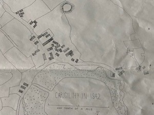 The village of Carrigillihy in 1842
 Mary and Beatty Cullinane late 1970s
Further Reading
-
Parish Histories and Placenames of West Cork - Bruno O'Donoghue
-
Exploring West Cork by Jack Roberts, Key Books, 1986.
-
Placenames Database of Ireland Logainm.ie entry for statutory version in Irish and English
- A Collection Of Placenames From Cork County, Barony Of West Carbery (East Div.),Volume 6 - Dr Éamon Lankford
- Castlehaven & Myross History Society Journal Vol. 1 - 2020
- Castlehaven & Myross History Society Journal Vol. 2 - 2021
- Castlehaven & Myross History Society Journal Vol. 3 - 2022
- Skibbereen and District Historical Society Journal Vol. 9 2013 - Cistercian Monastic Settlements in the Diocese of Ross (Jim Byrne) - Pgs 61-75
- Archaeological Inventory of County Cork. Volume 1: West Cork' (Dublin: Stationery Office, 1992)
- Parish Histories and Place Names of West Cork - Bruno O'Donoghue
- The Abbey of Sancta Mauro or De Fonte Vivo by J.M.Burke - Journal of the Cork Historical and Archaeological Society, 1904, Vol. 10, No. 64, Pgs 251-253
- Skibbereen - The Famine Story: Terri Kearney and Philip O'Regan - Pg 17
- See townlands.ie for information on this townland
Links
Go to Homepage
Go to list of Townlands
Go to list of Irish words used locally
Go to local Flora and Fauna

