An Chathair Gheal or Cahergal is a townland of 109 hectares or 268 acres and in the early part of the 20th century, 203 individual fields were mapped in this townland.
It is in the Electoral Division of Myross, in Civil Parish of Myross and the Roman Catholic Parish of Castlehaven and Myross.
An Chathair Gheal is bordered by Ardráth (Ardra) and Cuas Chróinín (Cooscroneen) to the south, Baile na Tóna (Ballinatona), An Chúil Dorcha (Cooldurragha), Lios Torcáin (Listarkin) and An Ráithín (Raheen) to the west, Cluain Cathail (Clontaff) to the north and Baile an Chalaidh (Ballincolla), Carraig Oilche (Carrigillihy) and An Sceachánach (Skahanagh) to the east.
OpenStreetmap contributors, with input from the Castlehaven & Myross History Society, have created a detailed townland map including all its minor placenames. Zoom in for further detail.
Etymology
An Chathair Gheal can be interpreted as the white stone fort. Bruno O'Donoghue's interpretation is the bright stone fort. No traces of the fort remain today
The present townland is an amalgamation of two old townlands namely Cahergal and Bawnishal. After the amalgamation Bawnisheal (which can be interpreted as Bán Íseal or low-lying pasture) became a sub-townland along with Béala'mhaide. According to James Burke B.L., the name Bealavaddy is mentioned in old grants. Local people say that the old name was Baile Mhíle Mhaide (the townland of the thousand sticks). Burke continues that this may be so but it had assumed the name Bealavaddy in the first decade of the 17th century. There is another version that says that the old name was Béal an Mhaide which may be a corruption of Béal an Bhaile (mouth of the village) .
History
People: The grandson of Patrick O' Leary of Cahergal, James Aloysius O' Leary, lived in Staten Island and was a Democratic member of the United States House of Representatives for New York (1935 - 1944) and his great-grandson Vito J. Fossella Jr. served as a Republican member from 1997 to 2009.
A family of Burkes emigrated from this townland to Butte, Montana and joined many other Irish miners there.
Dancing: There was a roadside dancing platform on the left-hand side of the road west of the two lakes. Although a concrete base was laid there in the 1950's in order to modernise it, very few Sunday dances were held there after that. A man called Thadió had a dance school at Cros na Marbh which is on the boundary between Cahergal and Cooldurragha.
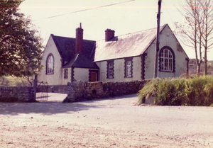
Quarries: There were a number of stone quarries in this townland and the stone was used for the building of houses as well as the wall along Cahergal Lake and for the building of the old school in 1885.
Flax: A stream on the Burns farm which separates Cahergal from Cooldurragha was used for soaking flax.
Shops: A Miss Burke had a shop opposite the creamery, the chimney stack of which is still visible today although covered with ivy.
Pat O' Mahony of Raheen built a shop and mill between the creamery and the old school circa 1960 which was managed by the late William (Wally) O' Neill. He later sold it to Lisavaird Co-op who closed the shop but continued to run the mill and also sell animal feed-stuffs for many years.
Famine: The book, "The Famine Story" lists the men from each townland that were working on the Myross Relief Scheme on 28th August 1846 during the Great Famine. These were public works that involved hard labour for a low wage for a workforce that were already weak and starving. Daniel Walsh was the only name mentioned for this townland
School: The former Union Hall National School was situated in this townland. It opened in 1885 and closed in 1989, It is a private house now. Around the year 1880 it appeared that the old school in the townland of Cooscroneen was getting too small to accommodate the number of pupils attending and owing to its proximity to Lough Cluichir there was very little room for expansion. On the 12th of December 1882 the Commission for Education sanctioned a grant of £510-6s-8d on expenditure of £800 or slightly less than two thirds of the cost of the school. The grant should have been two thirds but they decided, as there was £25 worth of materials and furniture in Cooscroneen, which could be transported to the new school, there was no need to pay the grant in full.
Built to accommodate 300 pupils it consisted of two rooms measuring 38 x 24 x 13 and 37 x23 x 13 plus two porches which could also be used as turf stores. Fr. McCarthy. Adm., Myross and Castlehaven acquired the site from Mr. J. Minihane and on the first of March 1883 a 900-year lease was signed with the J.P. Welphy, the landlord. It is not known who built the school but one of the stone masons involved was a member of the Maguire family of Ballinatona, who were noted stone masons. The stones probably came from quarries within the parish and the bricks around the windows and for building the chimneys were sourced from some other part of the county. They were transported to Skibbereen by train where they were collected by local farmers with horse and carts to bring them the final leg of their journey to Union Hall a distance of 8 miles.
The school was officially called “Union Hall National School” and not Cahergal after the townland or Myross after the parish. The doors of the school opened on September 25th 1885 to receive pupils from the old school at Cooscroneen. 132 girls transferred and probably a similar number of boys. The first teachers were – John Collins, Principal, Jer. O’Driscoll and Daniel O’ Donovan assistants. They were assisted by two monitors Patrick Shanahan (grandfather of the last principal of the school) and Tim O’Brien. In the Girls School Mrs. Cullinane was Principal and her assistants were Mary A. Collins and Annie Casey.. The school subjects: were Reading, Arithmetic, Writing, Geography, Agriculture, Book Keeping, Sewing and Dressmaking, Religious Education and Navigation. The length of the school day was from 9.30 a.m. to 4.00p.m. Some pupils paid fees and these remained on in the school for private tuition. Monitors also received tuition after 4.00p.m.
From 1909 onwards inspectors’ reports indicated that there was a serious problem with overcrowding in the school. In 1914 the Commissioners agreed to the extension of the girls’ room and the division of this room into three classrooms by the insertion of movable partitions. The male school took possession of one of the rooms leaving both schools with two rooms. There were open fires or stoves in all rooms and up to 1942 all fuel, mainly timber and turf, was stored in the class rooms. In 1962, with numbers falling fast, due partly to immigration, the total number of teachers fell from four to three. The Department decided to amalgamate both schools under the Principalship of Mr. Daniel Burke, Principal of the Boys’ School. Mrs. Catherine O’Donovan was the last principal of the Girls’ School and she remained on as a teacher until retirement age.
Interesting facts in relation to the school:
-
When built it was regarded as one of the finest buildings in West Cork
-
In Ireland there were two types of school in existence, those vested in the local parish the upkeep of which was the responsibility of the parish and church and those vested in the Board of Works who were responsible for their upkeep. Union Hall National School fell into the latter category.
-
If a pane of the glass broke, the chimneys needed cleaning, toilets had to be unblocked or a light fitting needed replacing a letter had to be written to the Board of Works outlining the different problems. This was followed by a visit from the Board of Works inspector checking out the list of what needed to be done. He returned to Cork and wrote a letter to a local builder who would duly carry out the repairs and forward his bill to the Board. After a number of months, the inspector would return to check out that the builder had indeed done the repairs to his satisfaction and he then received his payment. The whole process could take up to two years
-
So bad and outdated were the conditions in the school in the early 1980’s that the I.N.T. O. following a ballot of the teachers withdrew the staff for four days until the Department agreed to plough ahead with the building of a replacement. It was one of the first strikes in the country for better conditions for both teachers and pupils. The following year the school led the way again when the parish Priest at the time appointed a local farmer as one of the first lay chairpersons in the county.
-
Hundreds gathered in the school in September 1985 to celebrate its centenary and the photographs taken at the time will keep the memories of the occasion alive for many years to come.
-
The school closed in September 1989 with the opening of the new school beside the Church.
-
After the closure the school was renovated and reopened as a hostel known as “Maria’s Schoolhouse”. Its first guests were the cast of the film “War of the Buttons” directed and produced by Lord David Puttnam. Today it is a private residence.
-
The chestnut and lime trees that can be seen at the small gate of the school were planted in the 1880's.
Housing
As part of Griffiths Valuation in 1852, a survey of house quality was carried out to calculate what rates were due by each household. These were issued in the form of house books (Pg 1, Pg 2, Pg 3) and a guide on how to interpret these can be seen here. These show that fourteen of the twenty-one occupied houses in the townland at that time were class 3 (in addition there are three more vacant class 3 houses). This means that they were thatched houses with stone walls with mud or puddle mortar. Thirteen of these were descibed as old (more than 25 years) with six being in repair and seven being out of repair. The other class 3 house was described as medium (not new), deteriorated by age and not in perfect repair. The remaining seven houses were class 1, which meant that they were built with stone or brick and lime mortar. Three of these was described as medium, slightly decayed, but in good repair, three were medium, deteriorated by age and not in perfect repair while the other was old but in repair. All of the class 3 houses in the townland are between 5 foot 6 inches (!) and 7 foot 6 inches tall which indicates that they are single storey at this time. The class 1 houses were between 8 foot and 11 foot 6 inches tall.
By the 1901 census (Pg 1, Pg 2) there are now 18 occupied houses and all have walls of stone, brick or concrete. Twelve have a roof of slate, iron or tiles while the other six are still thatched. Fourteen houses have two, three or four rooms with nine having just two windows in front (which indicate that they are probably still single storey at this time) while three have four windows and two have five windows in front. The other four houses have five or six rooms with two having three windows in front while the other two have five and seven windows respectively.
When we advance to the 1911 census (Pg 1, Pg 2) there is an increase to 20 occupied houses and all still have walls of stone, brick or concrete. Thirteen now have a roof of slate, iron or tiles while the other seven are thatched. Seventeen houses now have two, three or four rooms with six having just two windows in front (which indicate that they are probably still single storey at this time) while three have three windows, three have four windows, four have five windows and the other has six windows in front.. The other three houses have five or six rooms with two having seven windows in front while the other only has two windows in front.
Places of Interest
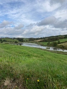
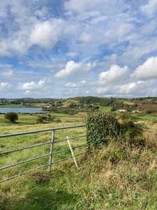
Lough Cluhir: There is a Lake called Lough Cluichir in this townland. It is said that a magical ship is seen on this lake every seven years. It was also said that man rode a white horse around the lake on every full moon.
Cahergal Lakes: There were actually three lakes known as Cahergal Lake in the past but only one can be clearly seen today though the other two, although overgrown at the edges, are still very wet. The three lakes were joined by a stream. Three people were drowned in the lakes over a period of 60 years with the most recent one being in the 1960s.
Lios: There was a ringfort (lios) in this townland. A ringfort is a circular fortified settlement that were mainly built during the Bronze age up to about the year 1000. It can no longer be seen.
Bóthar na Cailligh: This can be interpreted possibly as the road of the witch/hag - the origin of this is not presently known
Carraig Tighe Néil: This was the name of a rock in this townland. It can be interpreted as the rock of Neill's (Niall's) house. The location of this is not known (please contact us at [email protected] if you have information).
Béal a Mhaide Cross: This crossroads intersects three townlands, Ballincolla, Cahergal and Skahanagh. The interpretation can be seen above
Interesting Placenames
There is a field in this townland known as the School Field which was alongside the location of the old national school. Another field is known as the High Field. It is said that you can see 5 parishes from it. A hill was known as Leary's Hill which was named after a local family.
Other old field names in this townland have been captured as follows: Three Corner Field, Field Back of the House, Hill, Hilleen (small hill), Cow's Field, Flat Field, Mill Field, Patsy's Field (a group of fields were known as Patsy's Field), The Bog Field, The Gravel Pit (also known as the Swing Field or The Craigh (meaning unknown)), The Long Field, Calf's Field, Móinteán (reclaimed bog/peat-land - got its name as there is black ground in it according to Lankford), Páirc an Chnoic (field of the hill), Hallow Field, The Paddocks, Field Below the Road, The Picnic Tree Field (family had a picnic tree in this field), Corran a Die (meaning unknown), Well Field, Páircín na Croise (field of the cross), Quarry Field, Field Back of the House, Middle Móinteán (móinteán is rough land/ reclaimed bog), Southern Móinteán, Móinteán Mór (big rough land/ reclaimed bog), Lower Field, Furze Break, Car House Field (as a car house was built there), The Meadow, Páircín a' h-Uailigh (possibly Páircín na hUlla - small field of the apples), The Playground
If you want to see the actual locations of any of these, go to detailed townland map on Open Street Maps. If you know any other field names or place names in this townland (or if you need to correct any or give further background information), please contact us at [email protected]
Folklore
Lough Cluhir: There are a number of stories in relation to Lough Cluhir. It is said that it was created by St. Bridget after she was refused milk by a local chieftain. It was also said that there was an ollphéíst (monster) that lived in the lake. Click here for further information
Magical Ship: It is said that a magical ship is seen on Lough Cluichir every seven years. It was also said that Íomhar O'Donnabháin (from Castle Ivor) rode a white horse around the lake on every full moon.
Enchanted Palace It is said that Ivor O'Donovan still lives in Lough Cluhir in an enchanted palace deep beneath the lake
Old School: The old school is reputed to be haunted. It is said that lights were seen there at night-time. A woman who was cleaning the school felt something passing close to her but nothing was to be seen.
Families and Notable Residents
The Tithe Applotment books of 1829 list the following family names: Leary, Donovan, Walsh, Hennessy, Murray, Mahony, Walsh, Walsh, Donovan, Murray, Regan, White, Collins, Buckley, Burke, Donovan, Leary.
Griffiths Valuation of 1853 lists the following family names: Minaghan (Minihane), Mahony, Murray, Murray, Mahony, Hennessy, McCarthy, Whyte, Geany, Welply (land only - partly bog), Donovan, Sullivan, Leary, Leary, Leary, Regan, Collins, Donovan, Donovan, Leary.
The Census of Ireland of 1901 lists the following family names: McCarthy (with Regan (lodger)), McCarthy (with Driscoll (lodger)), Donovan, Donovan, Leary (with Burns (nephew and niece-in-law)), Leary (with Donovan (niece)), Mahony, Murray (with Mahony (servant)), Hennessy (with Hourihane (sister, nephew and 2 x niece)), Sullivan, Leary (with Coughlan (grandson)), Collins (with Driscoll (grandson)), Regan, Regan (with Walsh (lodger)), Walsh (with Donovan (daughter and son-in-law)), Leary (with McKennedy (daughter, son-in-law and 2 x grand-daughters), Leary, Sullivan.
The Census of Ireland of 1911 lists the following family names: Murray, Leary (with Coughlan (grandson)), Hourihane, Donovan, McCarthy (with Regan (mother-in-law)), Walsh (with Brady (daughter and 2 x grandsons) and Keohane (grand-niece)), Leary (with Burns (nephew, niece-in-law, 2 x grand-nephews and 2 x grand-nieces)), Donovan, Regan, Burns (with Murray (servant)), Leary (with Dinneen (sister)), Donovan, Sullivan, Leary, McCarthy (with Brady (uncle-in-law)), Collins, Leary, Regan, Mahony, Sullivan (with Glanton (daughter and son-in-law)).
Note: the term 'with' refers to a person or persons of a different family name staying in the house. This may have been an in-law or other relative, a guest, or a farm labourer/housekeeper or domestic servant.
Demographics and Landholding
| *Occupiers | Population | Change | Link to record | ||
| 1829 | Tithe Applotment | 17 | 102 (est) | 1829 | |
| 1841 | Census of Ireland | 31 | 198 | ||
| 1851 | Census of Ireland | 23 | 145 | ||
| 1853 | Griffith's Valuation |
19 (Incl 1 unoccupied) |
120 (est) | 1853 | |
| 1861 | Census of Ireland | 23 | 123 | ||
| 1871 | Census of Ireland | 25 | 132 | ||
| 1881 | Census of Ireland | 24 | 148 | ||
| 1891 | Census of Ireland | 22 (Incl 1 unoccupied) | 142 | ||
| 1901 | Census of Ireland | 18 | 116 | 1901 | |
| 1911 | Census of Ireland | 20 | 125 | 1911 |
*Occupiers generally equate to households having a house and land but may also include households having houses but no land.
Between 1656 and 1658 the Down Survey mapped all areas of the country to track ownership of land after much had been granted to followers of Cromwell after the war of the 1650's. The most prominent proprietors (titulados) of this townland at that time were Daniell Oge O'Donovan and Randulph Mc Daniell while the proprietor of the sub-townland of Baneishall was Dermodd McKnogher (possibly Mac Connor). This townland was spelt Cahergale at that time.
The proprietor of this townland in 1841 was Richard Beecher of Hollybrook, Skibbereen and the agent was Thomas Hungerford of Skibbereen. It was let to tenants at will at lump rents with the tithe being paid by the tenants.
In 1841, the soil was described as argillaceous (substantial amounts of clay), producing wheat, oats and potatoes. Fuel was described as scarce and the prevailing names were Walsh and Leary.
Images
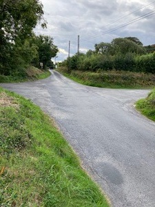 Béalawaddy Cross
 Loch Cluchir from Cahergal
Local Businesses and Services
| Name |
Union Homes |
| Description |
Construction company specializing in new builds, extensions, renovations/ external insulation |
| Contact |
Tel: +353 (0)86 375 1438 Email: Web:gormu.com |
Further Reading
-
Parish Histories and Placenames of West Cork - Bruno O'Donoghue
-
Placenames Database of Ireland Logainm.ie entry for statutory version in Irish and English
- A Collection Of Placenames From Cork County, Barony Of West Carbery (East Div.),Volume 6 - Dr Éamon Lankford
- Castlehaven & Myross History Society Journal Vol. 1 - 2020
- Castlehaven & Myross History Society Journal Vol. 2 - 2021
- Castlehaven & Myross History Society Journal Vol. 3 - 2022
- Parish Histories and Place Names of West Cork - Bruno O'Donoghue
- Growing Up on Céim Hill - Therese O'Mahony
- Skibbereen - The Famine Story: Terri Kearney and Philip O'Regan - Pg 17
- Union Hall National School 1885 - 1989
- Echoes FromThe Past - Article on Union Hall School - Pg 5-55
- See townlands.ie for information on this townland
Links
Go to Homepage
Go to list of Townlands
Go to list of Irish words used locally
Go to local Flora and Fauna

