Faiche Úrach or Fahouragh is a townland of 46 hectares or 114 acres and in the early part of the 20th century, 55 individual fields were mapped in this townland.
It is in the Electoral Division of Castlehaven North, in Civil Parish of Castlehaven and the Roman Catholic Parish of Castlehaven and Myross.
Faiche Úrach is bordered by An Ráithín (Raheen) to the north, Fearann Dáith (Farrandau) , Na Garráin (Gurranes) and Cill Achaidh Aingle (Killangal) to the east, An Gort Breac (Gortbrack) to the south and Bán na gColpaí (Bawnnagollopy) and Blúid Thoir (Bluid East) to the west
OpenStreetmap contributors, with input from the Castlehaven & Myross History Society, have created a detailed townland map including all its minor placenames. Zoom in for further detail.
Etymology
Faiche Úrach can be interpreted as Faiche Úrach (the lawn of green timber) or Faiche Lúrach (lawn of the yew trees). Bruno O'Donoghue's interpretation is Faithche Ordha which means the golden lawn (which could be linked to heather or furze growth) or furze blossom or Fathaidh Úbhrach. In his 1913 article in the Southern Star, JM Burke interprets this townland name as Faithche Inbrach (the exercise green of the yew tree)
History
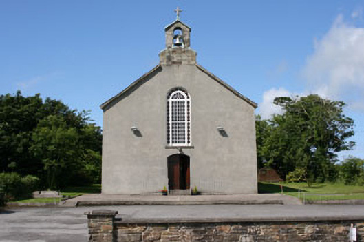
Saint Barrahane’s Catholic Church: Fahoura as a townland can boast of two churches. An earlier chapel in Bannagollaopy was discontinued . Probably at the turn of the 18th century, a church was constructed in a field close to the present cemetery. The ruins have disappeared but the location is known locally. It was built of stone and mud with a thatched roof. In 1835, Father James Mulcahy arrived from Aughadown and immediately made plans for a more modern stone church. This priest was also an agitator in the founding of a new school. The existing school was in Castletownshend, and is now the home of Collette O Sullivan.
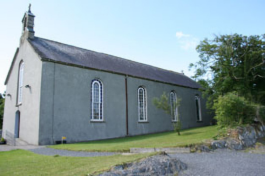
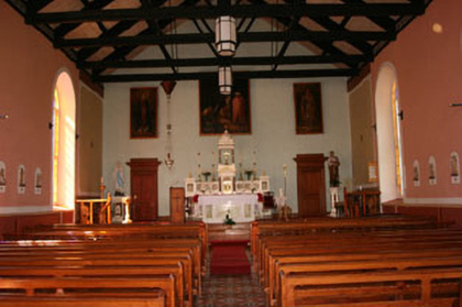
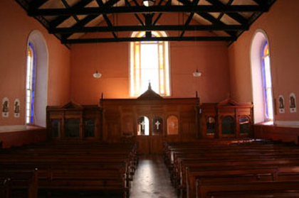
We know that the church was completed by 1841 - as it is mapped on the OS maps and a benchmark was chiselled into the doorstep. Father Mulcahy (1785-1853) championed the rights of his parishioners during and after the famine and is buried in the church. Perhaps his biggest legacy was the care he gave to over 800 orphans of the famine. By 1875 the church showed signs of dilapidation and the priest of the day, Father Timothy McCarthy, had a vision of a church to include a slate roof, a bell tower and an extensive entrance . Much of the rock to the rear of the church was chiselled away as well. Internally the church was transformed and looks similar to the interior today. A new Romanesque altar was fitted along with cast iron railings .The floor was covered in pine and the remainder tiled with enccaparic tiles. A balcony was also added. In an article in the Eagle and Cork County Advertiser of October 6th 1883, a full report is given on the official reopening. The Bishop of Ross, Dr. Fitzgerald, attended as did priests from all over the diocese.
The year of 1929 saw the church reroofed once again and new floors laid beside the altar. The beautiful trees in the church grounds were planted by Jerome O Regan, a teacher in the Workhouse in Skibbereen. In 1947-48, the church was plastered externally as the stone was porous. In former times the priest faced away from the people but this changed in 1975 . Now facing the people, other changes were coming as a result of the Second Vatican Council (1962-1965) . Latin was replaced by English. The Sunday devotions were not as well attended. Baptisms and funerals now took place in front of the altar. With the advent of the car, the church entrance was replaced with a non descript car park. The balcony was removed and soon the carved confessionals would follow. Locals are of the opinion that the present seats were made during the 1930s by a carpenter from Castletownshend. A new wall was built in 1983 at a cost of £5800 and later, the car park was extended. Forty years previously, a semi circular car park was developed across the road. The rings for restraining horse transport are still visible. Sometimes the children perform their Christmas Pageant in the church. Almost 150 years earlier the school children studied there as room was so scarce in the school. Mass is celebrated at 11.30 each Sunday.
Castletownshend National School: Anything to do with education in Castlehaven has a religious angle to it as well. This part of the parish was late in establishing a Board of Education school. Dooneen had a school in 1847 while Union Hall school at Cooscroneen was functioning October 1841. There were other schools in existence like Union Hall Female School and Castletownshend School (The Schoolhouse) but these were fee paying and were slightly discriminatory when it came to ‘stated religion’. A school existed in the present home of Collette O Sullivan on the street in Castletownshend with Denis McCarthy upstairs and his wife teaching at ground level . In 1841, this school was awarded a roll number (3066) and a salary approved for both teachers. Mary Anne McCarthy was to receive the sum of £8 annually.
In 1848, a report from the Superintendent dated, April 20th, stated ʻthat the children (male and female) in the Castletownsend National Schools were transferred to the Chapel in the middle of December 1847 in consequence of the crowded state of the school rooms.ʼ This prompted the diligent Father Mulcahy to apply for a grant for a new school, built from the ground up. There had been previous attempts to begin the process of a new school but a certain Rev. Mr. Bushe, Protestant Rector, had made progress impossible.
On July 5, 1849, the Board of Education granted £134 (equivalent to €20,435 in 2021) to build a schoolhouse at Fahoura to consist of two rooms, each 34 feet x 18 feet, that would accommodate 200 children in total, and £15 (equivalent to €1,955 in 2021) for “fitting up” the school. This was two-thirds of the total expenditure; the other one-third, £75 (equivalent to €11,195 in 2021), was to be provided by the people of the parish in the form of cash, or cash-in-kind (labour and/or materials for building). The lease was executed on March 1, 1850. There was a boys and girls school with the consecutive Roll Numbers of 5716 and 5717. A few problems arose with drainage of water and also the lease. The school entrance faced away from the road and in wet weather the entrance was mucky and muddy. A larger renovation was also warranted so that 'the present entrances to the school rooms should be closed up and a porch built in front as shown on the plan. Also, additional air space may be added to the rooms by raising the ceilings to the level of the tie beams, and gutters and down pipes can be fixed to the roof discharging into channel courses to carry off all roof and surface water.ʼ The estimated total cost of the improvements was £137 0s 0d .
A more pressing problem was the lease . By 1880, two of the lives of the leases had run out and the Board of Education was unwilling to invest any more money. The priest in charge in the 1880s decided that a better option was a new school in a new site ,across the road. The Commissioners granted his wish in March 1889 for a new school in the townland of Gurranes at a cost of £628 .One third of this money had to be raised locally either in cash, labour or materials.
So what became of the old school? It continued on as a school until about 1913 when operations ceased. Subsequently it became a meeting place for people including Conradh na Gaeilge and local sporting clubs. Later it became a CYMS Hall and was a popular venue for all night dancing, travelling shows and local drama .This group performed their own show at Christmas and Saint Patrick’s Day and then went on tour to other venues. Over the years, bazaars and bingo followed as did mass meetings on sand removal restrictions . Foróige followed with discos and hops and at Christmas, turkeys could be won by playing cards. The War of the Buttons was even filmed here but the parish could never decide what was best for it. Some say it was haunted but was it the curse of the leases still hanging over it ? In our schooldays, the Christmas play with ‘black lighting’ was a must for both parents and children. The original plaque of the school is still visible close to the original entrance . It never got to call itself Castlehaven National School as the original school bore the name Castletownshend. It could have been named after a Saint but Dooneen were first in with Saint Barrahane.
 Christmas Play c 1968
 Old Hall
Housing
As part of Griffiths Valuation in 1853, a survey of house quality was carried out to calculate what rates were due by each household. These were issued in 1850 in the form of house books and a guide on how to interpret these can be seen here. These show that 5 of the 6 houses in the townland at that time were class 3 (the Roman Catholic church was also listed). This means that they were thatched houses with stone walls with mud or puddle mortar. Two are described as being old (more than 25 years) but in good repair while the other three are also old but out of repair. There are also a class 1 house in the townland at this time which means that it was slated and built with stone or brick and lime mortar - it was described as medium (not old), slightly decayed, but in good repair. All of the houses in the townland at this time are between 5 foot and 8 foot tall which indicates that they are single storey at this time.
By the 1901 census, there were only three occupied houses (plus a church) and two had walls of stone, brick or concrete with a roof of slate, iron or tiles while the other was still thatched with walls of mud, wood or other perishable material. The thatched house has two, three or four rooms with three windows so it was maybe probably still single storey at this time. The other two dwellings had five or six rooms each with five windows.
When we advance to the 1911 census there is an increase to six occupied houses (and a church) in this townland . All now have walls of stone, brick or concrete with a roof of slate, iron or tiles. One house has two, three or four rooms with one window in front, two have five or six rooms with two windows in front and the other three have seven, eight or nine rooms.(two with five windows in front and the other with seven). .
Places of Interest
Gallán: There is a gallán (standing stone) in this townland. Standing Stones may have been boundary markers during the Bronze/Iron Age. Alternatively, they may have been commemorative monuments or may have been used to mark burial places.
Lios: There is a ringfort (lios) in this townland . Ringforts were circular fortified settlements that were mainly built during the Bronze age up to about the year 1000. According to the Historic Environment Viewer, there was a circular hut-site in this ringfort
 Lios in Fahoura
St Barrrahane's Roman Catholic Church (Architectural information): The church is described in the National Inventory of Architectural Heritage as a freestanding gable-fronted double-height Roman Catholic church, built c.1840, comprising single-bay entrance front, four-bay nave, later sacristy, and recent toilet extension to side (south). Pitched slate roofs with uPVC rainwater goods, coursed limestone bellcote, and concrete cross finials to gables. Rendered walls. Round-headed openings with multiple fixed pane windows having sunburst fanlights and stone sills. Camber-headed door opening with timber battened double-leaf doors having strap hinges. Recent concrete steps and ramps with metal railings. Interior consists of open truss roof, polychrome tiles to aisle, marble reredos and carved timber confessionals flanking interior porch. Outbuilding to north-west. Rubble limestone walls with gate piers and wrought-iron gates to front. Built to a simple plan, this large church stands in an isolated position to the north-west of Castletownshend. The retention of original features such as the expansive sash windows and fine stone bellcote add to the building's character, as do interior features such as the polychrome tiles and finely carved confessionals.
The Historic Environment Viewer lists the ringfort, hut-site and church mentioned above
Interesting Placenames
Besides the places mentioned above, we have also mapped the following field names in this townland: Páirc Mhór (big field), Páirc Bheag (small field), Browne's Field, The Big Field
The Castletownshend Road and the Bán Road run through this townland. The latter is named after a local family.
If you want to see the actual locations of any of these, go to detailed townland map on Open Street Maps. If you know any other field names or placenames in this townland (or if you need to correct any or give further background information), please contact us at [email protected]
Folklore
Families and Notable Residents
The Tithe Applotment books of 1825 list the following family names: Seruth (Scruch / French?? - illegible), Brown.
Griffiths Valuation of 1853 lists the following family names: Hegarty, Browne, Donovan, Browne, Donovan, Regan. It also includes the Catholic Chapel (with Rev. Mulcahy as the immediate lessor)
The Census of Ireland of 1901 lists the following family names: Hegarty, Browne, Hayes
The Census of Ireland of 1911 lists the following family names: Hayes (with Mahony (niece)), McCarthy, Hegarty (with Donovan (aunt)), Browne (with Hegarty (mother-in-law and brother-in-law) and Murphy (son-in-law and daughter)), Dwyer, Hegarty (with Burke (servant)).
Note: the term 'with' refers to a person or persons of a different family name staying in the house. This may have been an in-law or other relative, a guest, or a farm labourer/housekeeper or domestic servant.
Demographics and Landholding
| *Occupiers | Population | Change | Link to record | ||
| 1825 | Tithe Applotment | 2 | 12 (est) | 1825 (Frahoura) | |
| 1841 | Census of Ireland | 14 | 90 | ||
| 1851 | Census of Ireland | 12 (Incl. 2 unoccupied) | 57 | ||
| 1853 | Griffith's Valuation |
6 |
30 (est) | 1853 | |
| 1861 | Census of Ireland | 9 (Incl. 3 unoccupied) | 35 | ||
| 1871 | Census of Ireland | 5 (Incl. 3 unoccupied) | 26 | ||
| 1881 | Census of Ireland | 6 (Incl. 1 unoccupied) | 27 | ||
| 1891 | Census of Ireland | 4 | 24 | ||
| 1901 | Census of Ireland | 4 (incl. 1 unoccupied) | 18 | 1901 | |
| 1911 | Census of Ireland | 7 (incl. 1 unoccupied) | 38 | 1911 |
*Occupiers generally equate to households having a house and land but may also include households having houses but no land.
Between 1656 and 1658 the Down Survey mapped all areas of the country to track ownership of land after much had been granted to followers of Cromwell after the war of the 1650's. At this time the proprietor (titulado) of this townland was Charles McCarthy Reagh who was deescribed as an Irish papist. This townland was part of Rathnapoole, Monymohalahan & Lisranckan at that time.
The proprietor of this townland in 1841 was Colonel John Townsend and his agent was Charles Clarke of Skibbereen. It was sub-let to tenants without a lease.
In 1841 the soil was described as coarse, mixed with some arable, producing middling crops of potatoes and oats
Images
 Dance in 1950s
 Church
Further Reading
-
Placenames Database of Ireland Logainm.ie entry for statutory version in Irish and English
- A Collection Of Placenames From Cork County, Barony Of West Carbery (East Div.),Volume 2 - Dr Éamon Lankford
- Castlehaven & Myross History Society Journal Vol. 1 - 2020, pp81-82 - John Collins.
- Castlehaven & Myross History Society Journal Vol. 2 - 2021
- Castlehaven & Myross History Society Journal Vol. 3 - 2022
- Parish Histories and Place Names of West Cork - Bruno O'Donoghue
- Local Names - JM Burke (J.M.B) - Southern Star - 4th October 1913
- See townlands.ie for information on this townland
- National Inventory of Architectural Heritage: https://www.buildingsofireland.ie/buildings-search/building/20914255/st-barrahanes-roman-catholic-church-fahouragh-cork
Links
Go to Homepage
Go to list of Townlands
Go to list of Irish words used locally
Go to local Flora and Fauna

