Na Garráin or Gurranes is a townland of 31 hectares or 76 acres and in the early part of the 20th century, 19 individual fields were mapped in this townland.
It is in the Electoral Division of Castlehaven North, in Civil Parish of Castlehaven and the Roman Catholic Parish of Castlehaven and Myross.
Na Garráin is bordered by Cill Achaidh Aingle (Killangal) to the north, Baile an Chaisleáin (Castletownshend) and Cnoc Droma (Knockdrum) to the east, and Faiche Úrach (Fahouragh) and Fearann Dáith (Farrandau) to the west.
OpenStreetmap contributors, with input from the Castlehaven & Myross History Society, have created a detailed townland map including all its minor placenames. Zoom in for further detail.
Etymology
Na Garráin was interpreted by Bruno O'Donoghue as the groves. Alternative interpretations are the shubberies or the small woods. The earliest reference seems to be in the Down Survey of 1655 when it was known as Gorrenakeugh - which is possibly an anglicised version of Garráin an Cheo (the foggy groves/shrubberies). After this date, the spelling of Gurranes or Garráin was widely in use. It is interesting to note that there are 347 townlands in Ireland with variant of Garrán in the name.
History
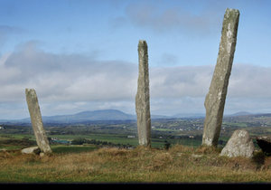
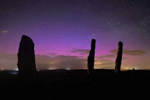
The Three Fingers: Our Celtic ancestors celebrated the feasts of Imbolg, Bealtaine,Lúnasa and Samhain with many rituals. These dates correspond to the beginning of each season. Other cultures celebrated in similar ways. It is reasonable to believe that these four festivals were celebrated in this parish and remind us of a time when there were many gods that needed pacifying. Altars were built as in the Three Fingers. Perhaps those standing stones were another way to honour their gods or even to mark the final resting place of a Celtic leader or chief.. The Three Fingers are probably 4000 years old but no one is quite sure what they were used for. Without excavation we will never know if traces of wood burning or indeed fragments of bone are on the site.
What is most interesting is that they were built to last, stuck deeply into unyielding rocky ground. The predominant rock in the parish is fine grained sandstone laid down during Devonian times about 350 million years ago. They were most likely quarried locally and moved up to a height of 110 metres using grass ropes (sugáns) and circular logs as makeshift wheels or rollers. There were originally five fingers but only four remain on the site as the fifth was plundered and used in a village garden. The fourth stone lies prostrate on the site in the shadow of the other three. The three upright stones vary in height from 2.3 to 4 mts. and at varying distances apart. Their east-northeast alignment would help the claim that they mark the rising summer solstice sun. Many say that standing stones were aligned with the brightest star Sirius as it set at the spring equinox and rose at the autumnal equinox.
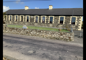
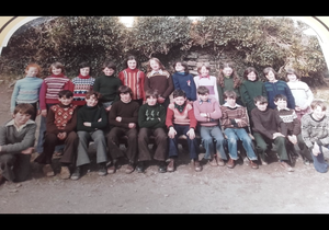
Castletownsend National School:The large stone-faced building is over 130 years in existence. It replaced a smaller school building just across the road. The site was at one time a haggard for threshing corn and oats,The priests of the time, Father O Sullivan and later Father John Lyons, made valiant efforts to have the dilapidated school of 1849 replaced. After much debate and many obstacles, a school to accommodate 300 pupils got the go ahead. A grant of £628 was received, equivalent to €102,000 in today's money, and the contractor was William Casey of Skibbereen. Problems arose with the toilets and the rocky and uneven playground. The Board of Education insisted that as Father Lyons had taken over the management of the school before it was completed, they didn’t have to level the play areas. The surface remained until this century, when major refurbishment and extensions eventually levelled the entire area. Many childhood memories are of the old playground, the stone wall segregating boys from girls and hearing bottles of tea around the pot-bellied stove. Many others recall the maps on the wall or the summer holidays that seemed to last forever, while some recall a time when education was not much fun. A new central school was mooted in the 1960s but this plan was shelved. The school fell into such a state of disrepair that many classes took place in temporary accommodation. It is a tribute to the people of the parish that, in poorer times, they always raised the local contributions and to the teachers and pupils for their efforts. Let’s not forget that two teachers taught all eight classes until 1969, when a third and later on a fourth teacher arrived.
Housing
As part of Griffiths Valuation in 1853, a survey of house quality was carried out to calculate what rates were due by each household. These were issued in 1850 in the form of house books and a guide on how to interpret these can be seen here. There were only two houses in the townland at this time and both were class 1 which means that they were slated dwelling houses built with stone or brick and lime mortar (as opposed to thatched houses with stone walls with mud or puddle mortar) One is described as medium (not new), slightly decayed, but in good repair while the other is medium, deteriorated by age and not in perfect repair. One is 6 foot 6 inches tall so it may be single storey while the other is 10 foot tall and possibly has two storeys.
By the 1901 census, there are now 3 houses in this townland and all have walls of stone, brick or concrete with roofs of slate, iron or tiles. Two houses at this time have two, three or four rooms with two windows in front so they are probably still single storey at this time. The other has five or six rooms with eight windows in front so is probably two storey. The National School is also listed in the census at this time.
When we advance to the 1911 census, there are still 3 houses in this townland an,not surprisingly, all still have walls of stone, brick or concrete with roofs of slate, iron or tiles. Two houses at this time still have two, three or four rooms with two windows in front so they are probably still single storey at this time. The other now has seven, eight or nine rooms with seven windows in front so is probably two storey.
Places of Interest
Fulacht Fiadh: There was a fulacht fiadh in this townland. These were cooking pits and were typically constructed during the late Bronze Age (c. 1500 – c 500 BC
Cill: There is a disused children’s burial ground in this townland. Close to the road to Castletownsend it was most probably damaged during the building of this road in the early 1800s. Locals speak of unusual and sad sounds coming from this place. There were stone steps from the road to the cillín but at present these can't be found.
Pound: There is a pound at the east end of this townland. These were used to hold cattle that were taken from local farmers who had failed to pay their tithes to the Church of Ireland in the early 1800s
Cuan Dubh: This is an area along the poorly-maintained road that seems to have been cut out from the land. It can be interpreted as the dark harbour although an alternative interpretation of cuan is curve which would also make sense. However a story on page 217 of the School's Collection suggests that it should be called the Cúm Dubh which would be the dark hollow
The standing stones, fulacht fia and children's burial ground mentioned above are all mapped on the Historic Environment Viewer. However it also mentions two redundant records (possible cup-marks) and a bullaun stone (100m north of Knockdrum) in this townland
.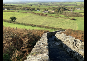 View of Garranes from Knockdrum
Interesting Placenames
No field names or any other placenames have been recorded for this townland. If you are aware of any, please contact us at please contact us at [email protected].
The Castletownshend Road runs through this townland and there is a cross known as Crowley's Cross.
Folklore
Fourth Finger: There is a story that the fourth finger was damaged by the Black and Tans during the War of Independence
Threshing: According to a story in the School's Collection, there was a haggard on the site where the current school was built. The threshing machine would come for a week and the local farmers would bring their corn here to be threshed. This was done as a meithel and all of the neighbours would help. The men had to work very hard so one of the workers, who was getting tired, came up with a plan to stop the machine. He quietly slipped a mouse into the ear of one of the four horses working the machine. The animal got restless and had to be replaced so the farmers got a rest while the replacement horse was being set up. It was said that a man by the name of Swanton owned the land at that time. It is interesting to note that there was a Swanton family renting land in Gurranes at the time of the 1853 Griffith's Evaluation but they were not present for the 1901 census
Carraig Throunce: According to another story in the School's Collection, there is a rock north east of the Three Fingers that is known as Carraig Throunce (Throunce's rock). It was named after an English forester who was brought there by theTownsends when the wood was being planted. It was said that he grew the trees from seed in nursery gardens where part of the wood is today. There was an Elizabeth Throunce that There is also an elevation above the pound that was known as Langley's Height. JM Burke speculated that it might have got its name from the family Angley (Aingle) that is now extinct.
Families and Notable Residents
The Tithe Applotment books of 1825 (townland is listed as Granes and Knock Drum at this time) list the following family names: Rowntree, Townsend, Donovan, Hurley plus a pound holding
Griffiths Valuation of 1853 lists the following family names: Hurley while Samuel Burchill had a herd-house here. In addition, the following families rented land here: Rev. M. Fitzgerald, Townsend, Chambers, Swanton, Atkins. Also DenisMcCarthy leased a national school from the National Board of Education.
The Census of Ireland of 1901 lists the following family names: Collins (with Donovan and Cronin (both servants)), Keane, Hayes
The Census of Ireland of 1911 lists the following family names: Collins, Sullivan, Hayes
Note: the term 'with' refers to a person or persons of a different family name staying in the house. This may have been an in-law or other relative, a guest, or a farm labourer/housekeeper or domestic servant.
Demographics and Landholding
| *Occupiers | Population | Change | Link to record | ||
| 1825 | Tithe Applotment | 5 | 30 (est) | 1825 | |
| 1841 | Census of Ireland | 0 | 0 | ||
| 1851 | Census of Ireland | 2 | 18 | ||
| 1853 | Griffith's Valuation |
1 |
6 (est) | 1853 | |
| 1861 | Census of Ireland | 2 | 12 | ||
| 1871 | Census of Ireland | 2 | 10 | ||
| 1881 | Census of Ireland | 3 | 21 | ||
| 1891 | Census of Ireland | 2 | 17 | ||
| 1901 | Census of Ireland | 3 | 22 | 1901 | |
| 1911 | Census of Ireland | 3 | 18 | 1911 |
*Occupiers generally equate to households having a house and land but may also include households having houses but no land.
Between 1656 and 1658 the Down Survey mapped all areas of the country to track ownership of land after much had been granted to followers of Cromwell after the war of the 1650's. At this time the proprietor (titulado) of this townland was Sleughteig McCargh. The townland was called Gorrennakeagh at this time.
It is interesting that the population of Gurranes and the neighbouring Killangal dropped to zero between the 1825 Tithe Applotment and the 1841 census. It is quite possible that these may have been due to evictions.
The proprietor of this townland in 1841 was Colonel John Townsend of Castletownshend and his agent was Charles Clarke of Skibbereen. It was all in the possession of the proprietor, mostly as pasture when let to tenants.
In 1841 the soil was described as middling, producing middling crops of oats and potatoes.
Images
 Thomas John O'Donovan NT and Father Lamb at the 3 Fingers in 1921
Further Reading
-
Placenames Database of Ireland Logainm.ie entry for statutory version in Irish and English
- A Collection Of Placenames From Cork County, Barony Of West Carbery (East Div.),Volume 2 - Dr Éamon Lankford
- Castlehaven & Myross History Society Journal Vol. 1 - 2020
- Castlehaven & Myross History Society Journal Vol. 2 - 2021
- Castlehaven & Myross History Society Journal Vol. 3 - 2022
- Parish Histories and Place Names of West Cork - Bruno O'Donoghue
- The Schools’ Collection, Volume 0298, Page 258 - The Threshing
- The Schools’ Collection, Volume 0298, Page 219 - Throunce
- The Schools’ Collection, Volume 0298, Page 243 - Langley's Height
- The Schools’ Collection, Volume 0298, Page 217 - Cúm Dubh
- See townlands.ie for information on this townland
Links
Go to Homepage
Go to list of Townlands
Go to list of Irish words used locally
Go to local Flora and Fauna

