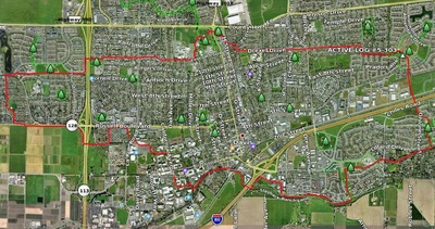
 The Davis Bike Loop as seen by a GPS, a bike and Google Earth. This map shows the original, longer 2007 routing through the UCD campus between California Ave. and the east end of the Arboretum.
| Map of route |
| http://www.davisbicycles.org/DavisBikeLoopOrange Lines are Paths, Green Lines are Streets |
| Bike Loop map suitable for printing |
| davis_bike_loop_map_29apr14.pdf updated 2014 |
| Video of route |
| YouTube Vimeo (better quality) |
| Google Earth/GPS of route |
| http://www.crazyguyonabike.com/doc/page/?page_id=112808 |
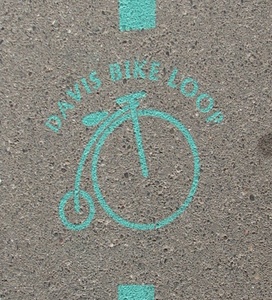
The Davis Bike Loop is an approximately 12 mile long route through The Greenbelt that passes through most of the major pieces of bicycle infrastructure in town (also check out bike tunnels and bike bridges). Davis Bicycles! lobbied the City to create the official route with painted pavement markings. Before these markings were painted in August 2007, the route was marked by unofficial chalked arrows with a capital "G."
The route is suitable for walking, jogging or bicycling. It runs mostly on paths and trails, but has some sections on quiet residential streets. The route was chosen to be safe and pleasant, but not fast. It is suitable for casual bicyclists who don't mind going slow and yielding to pedestrians, young riders, old riders, and new riders. It is also great for experienced riders who want a slow, comfortable ride on a sunny day. The route is designed to be used as a navigable route for children, so parents can send their kids across town for a trombone lesson on a safe, easy-to-follow route. If it is your first time following the route, however, it is strongly suggested you pay careful attention to the path markers and look everywhere for them. The path does not take a straight path through the greenbelts and it is easy to get off course because you aren't paying attention and can easily miss a sudden turn.
Note to map users on routing of Bike Loop between Davis Commons, California Ave.: Google Earth GPS links, gpx files give an out-of-date route for approximately 1/2 a mile of the Bike Loop between Davis Commons (east end of Arboretum near RR tracks) and California Ave. on the UC Davis Campus. The first link above and the map updated 2014 give the accurate, current routing in this area.
If you have a GPS you can upload the davisbikeloop-whole.gpx file into it if you want to have it route you through the winding route around Davis. The map above is the route as displayed within google earth, and you can also download the Google Earth File to browse the path yourself: davisbikeloop-whole.kmz. The 2008 version of the one-page printable map loopbrochure.pdf shows the old route through campus, as well as connecting greenbelt paths.
Starting in May 2010, Davis Bicycles! has put on an annual event called Bike Loopalooza. (The 2012 event was on Sunday, May 6th.) The family-oriented event is aimed to show the convenience of using the Bike Loop to bike to school. The event includes ten stations a half-mile to two miles apart along the route with activities such as a bicycle safety skills course, face-painting, birdwatching, and playing with water guns and water balloons. Kids get passport stamps at each station, receiving small prizes after three stations and a certificate if they complete the whole loop.
History
The system was proposed in the 1980s by Landscape Architecture professors Mark Francis and Kerry Dawson (also director of the UC Davis Arboretum at the time) along with then-student Stan Jones. Several greenbelts had already been built, such as the sections in Village Homes and the North Davis Greenbelt, but they were not connected in a network and there were no plans to do so. Francis and Steve Greco proposed a suburban greenway system with a loop around the periphery of the city, a second loop several miles out in the country, and spokes radiating out from downtown/campus connecting out to the two rings. Their proposal was adopted as part of the city's General Plan in the late 80s.
In the early 1990s, the plan was carefully followed during the building boom greenway components were built whenever land was developed. We are fortunate that Francis and Greco had the vision to propose the greenway and our leaders adopted it, because it would be impossible to retrofit such a system into existing neighborhoods. Unfortunately, the "rural greenway" loop was not advanced as a greenway, though the current open space policy is a direct result of the original greenway proposal, and since the city owns land or holds conservation easements on it, there is a possibility that the outer loop can still be built. The "spokes" have not been emphasized as much as the greenway loop, but there are fairly good routes connecting the loop to the core in most places.
In the early 2000s, Francis would offer periodic tours of the greenway, and would always conclude that it was only about 70% done, and probably wouldn't be completed in his lifetime. All of the segments were well-used by neighborhood residents, but as there was no navigation system, people had to learn to find the best route on their own. UC Davis Institute for Transportation Studies student Chris Congleton marked the route with stenciled arrows in 2003 for a transportation conference, but the graffiti patrol erased the marks before the conference began. Also around that same time, improvements were constructed that made a complete, navigable route around the entire city. These included the Putah Parkway tunnel under the railroad tracks behind Davis Commons in 2003, a section by Montgomery School, and at the 5th St. Tunnel/Mace Ranch Park in 2005. Without any fanfare, and without anyone really noticing, the greenway loop became complete to the point where it was functional and usable as an inter-neighborhood transportation route.
In September 2007, Davis hosted the California Walk/Bike Conference and Association of Pedestrian and Bicycle Professionals conference. The Davis Bicycles! group thought it would be beneficial to invite the attendees on a self-guided tour of the greenway, and suggested to City Council and Public Works that the mostly-complete greenway was now ready to be marked. Davis Bicycles! drew up a map, did a few test rides of the loop and submitted it to the Campus Committee on Bicycles and the Bicycle Advisory Commission both of whom gave the route tentative approval.
In July, the stencil was complete and crews marked the loop in August and September, 2007. The stencils were repainted in the summer of 2008.
On October 21st, 2007, an opening ride and ceremony was held. A video of the event can be seen at http://www.youtube.com/watch?v=W7dMuyONoFs.
 One of the markings used for the loop
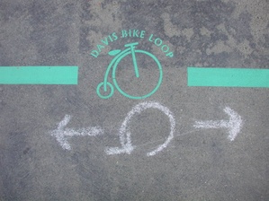
  What the markings look like to a bicyclist
  A friendly city paint crew laying out a stencil by the South Davis Bike Path in August 2007
 Old Mark, New Mark, White Mark, Green Mark
  Bike Tour Maps installed in 2007
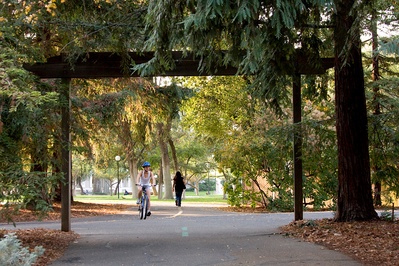
  Before it was rerouted in 2010, the bike loop followed a longer, meandering route through part of the arboretum, including the unpaved path through the redwood grove and under the A Street underpass where cyclists had to dismount.
2007-09-04 19:15:13 I saw some of these in West Davis and Village Homes last night, and followed them down Russel, but they dropped before I got to campus. —GeoffJohnson
2007-09-04 19:25:32 The ones I saw were on Drexel Drive and Loyola Drive. —JasonAller
2007-09-04 22:24:13 At the head of bike path leading from J Street towards the bike tunnel that goes under the tracks. —KevinChin
2007-09-04 22:56:03 I believe Ted Buehler may have been involved with this. He might have more info. —jefftolentino
He was. Who do you think is behind Davis Bicycles? -wl
Having him post a map would spoil the fun of figuring out the loop based on the street markings people find. :) —kc
2007-09-05 09:34:07 I saw them on 14th St. and the path that goes past Community Park. —CovertProfessor
2007-09-05 12:26:40 must. get. a. map. —WesHardaker
Does anyone know how to do a legend in googlemaps? —TedBuehler
2007-09-11 10:59:05 Good work on the map, Wes. —jefftolentino
-
Thanks... I'm tired now though. I pulled a bike trailer (loaded with a kid for half the way) for the entire ride. —WesHardaker
2007-09-11 11:09:19 The page looks awesome!
2007-09-17 The markings are complete now, including campus (UCD). My 10-year-old and I did the complete loop on tandem last Saturday and we loved it. Got us from West Davis to South Davis and back with no need to look at any maps or any worries about getting lost or needing to deal with unsafe spots. It created a nice sense of exploration and ownership and community. We met and talked to several different people, including 2 older ladies who were out exploring the loop. People are discovering this loop—it's a great ride. The pathways—largely off-street—are beautiful and it really makes you proud of Davis.
—MikeR
2007-09-18 06:41:35 I have also completed a tour of the loop (though not all in one day due to other tasks; the map above was actually hand-pieced together from various days of GPS tracks). Anyway, the loop is certainly fantastic. It does make some interesting choices, though. I was sure it was going to turn north into the Northstar Greenbelt as it's one of the best sections of paths in Davis. But it didn't and headed down 14th instead. Overall, though, the loop is certainly a great trip. —WesHardaker
2007-11-02 00:53:11 Already many of the green markings are fading away. Using signposts (or road marking quality coatings) would be better. Corresponding, taking out the overly superfluous routings would help as well. —jimc
2007-11-25 12:59:45 Wow! This is amazing! I have only been biking now for about four weeks since I moved here and just have an Electra Townie 3 speed cruiser and love this loop and was able to do it all (except for a bit of walking on the Dave Pelz overcrossing). I start near Mace Ranch where it winds through charming residential areas along Loyola and Drexel-all the little old houses, which also avoids that wicked J street hill on Covell; then it winds around the other side of the North Davis Elementary school along 14th St & Villanova, finally turning through Sycamore Park and Arroyo Park and hitting that very cool stretch of bike path that winds through the community gardens and co-ops of Village Homes (I had never seen that portion of Davis and doubt I would just by car!). After that you hit beautiful green farms along side you on Evenstar, turning down through a great trek through portions of the UC Davis campus (catching some of the buildings, the art and those egghead sculptures)and then scenic shots of the arboretum. Coming out the Arboretum you follow along the Putah Creek and more rich farmland, wind through a few more residential parks until you hit the Dave Pelz overcrossing and are back at the beginning.
This loop is great for anyone who comes to visit-even if they haven't biked for a while as long as you take it slow it still only takes 2 hours to complete. Kudos to the designers! —Judge
2008-03-08 15:40:14 The bike loop is great fun - it is fairly well marked, although we got a bit lost somewhere between the UCD domes and the bike church, but we managed to pick up the trail again. It's a lovely, fun ride that explores parts of Davis you may not otherwise visit. —AcMach
2008-03-13 15:23:34 Great bike path, but I got lost and never picked up the trail, but I managed to find my way back. Must try again soon! —VTang
2008-03-13 16:23:24 When I did the loop, I lost the trail going westbound around 5th and Orchard Park Drive. Must not have seen the turnoff that leads into Russell Park, but I reconnected with it when I intersected with the path that leads to the southern 113 bike overpass. Great ride; it made me realize how much of Davis I really haven't seen. —KevinChin
2008-03-14 08:50:35 Riders, be aware! "The route was chosen to be safe and pleasant, but" I was hit by a car at an inferior intersection on the Loop: where Villanova dead ends into Sycamore. Not a criticism of the Loop, but rather to say that there are many hazards along it. Keep your eyes and ears awake, your hands on the brake levers, and wear your bicycle helmet, please! —DougWalter
2008-03-19 13:25:47 Finally managed to complete the loop! It's a great ride and so far I've been back at least every other day. It's a good idea to really pay attention because there are quite a few intersections where cars don't have to stop. Still an excellent path to bike though. —VTang
2008-03-30 20:36:02 I really enjoy the loop, you do have to be careful on the street intersections, but it's a nice ride that allows you to see many of Davis' parks. —LizMelack
2008-04-06 13:26:51 ive been on it twice now and it is good exercise! try it today! —davisrox
2008-07-13 15:09:46 i am going to do this on friday july 18. any good advise as what to bring and etc?? —applepearpp
2008-07-17 09:41:52 Davis Bicycles! will be riding the Bike Loop on July 29th with City Bike/Ped Coordinator Tara Goddard to review the route in preparation for repainting it. Start will be at 6:30pm in Community Park across from Rainbow City. For more information contact [email protected] —LeoRainer
2008-08-23 15:50:16 the J st tunnel is a killer. would suggest to take a left at the end of J st instead. —applepearpp
2008-08-25 06:26:16 I noticed the other day that at least many of the stencils have been repainted. Hopefully with better paint this time. —WesHardaker
2008-09-21 14:58:52 Why does the Loop not include the North Davis Greenbelt? It would seem natural when going east coming from the 113 bike overpass to turn left on Sycamore and then catch the green belt at either Antelope or Alvarado. Or another natural loop is to follow the bike path on H street and connect on F street, coming back to the current loop on the Covell bike over-crossing into Community Park. I'm sure there must have been some discussion of this. —CarlTesterman
2009-05-31 14:00:18 Yesterday, my friend Emily and I got confused on the Bike Loop for a little bit because the markers disappeared soon after we passed the bathrooms at the Community Park heading east. I suspect that since the new crossing was constructed near the Davis Art Center, no one has painted any new Bike Loop markings. But then we crossed F Street on a hunch and picked up the trail again near the baseball field on H Street. —CalamityJanie
2009-06-30 15:59:48 The markings around Davis are pretty easy to follow, however the markings on campus have definitely faded a lot. Other than that, a great aerobic exercise. Although when I rode the loop, it was over 100 degrees outside and I think I got heat exhaustion. —JustinAi
2009-09-23 21:10:13 I'm training for a marathon. This looks like it would be good for a long run. Has anyone run this route? —Melisa
I'm not a runner, but I've biked it multiple times. If you like running on cement (many don't) it should be a good run. There will be some issues where you're running on city streets with blocks where you'll have to jump on/off sidewalks to cross streets and a few places you'll need to wait for traffic lights, but other than that it should be nice. —WesHardaker
2010-02-08 10:23:49 My friend and I tried the bike loop yesterday, and also lost the trail around the Community park going east. We crossed the street there to the baseball field to see, but didn't see any markers besides a sign that directed us to go two different directions. We didn't go on the south side of the baseball field, but tried going north then east, and there were no markers in that direction so I assume we missed it and were supposed to go on the south side. Can anyone confirm this for next time we try? —VictoriaVanBerlo
2010-02-15 09:34:41 When you cross F Street, veer to the right around the south (right hand) side of the Little League field. This map may be helpful. (Ignore the response below from WesHardaker. Correct about the new pavement at F Street, but misread "east" and was thinking "west" ..."Oh, the other east!") —RussellReagan
2010-02-08 11:07:56 If you passed the baseball fields and crossed F street you'll likely have noticed that the sidewalk on the otherside is now completely new and probably hasn't been painted with bike loop markings, unfortunately. Head across and aim for the community pool to the south west where you should pick it up again on the far side of the pool. Eventually, it turns to the west along 14th street. —WesHardaker
2010-02-13 12:43:26 The bike loop is a great way to give someone a tour of Davis, it goes through all the important areas and is very "Davis" because it is on a bike. —DagonJones
2010-02-22 12:46:14 We did the bike loop on President's day (nice day). took us about an hour and 45, not riding hard at all. A couple spots need to be 'refreshed with painted markers' i.e, the new line from community park to F to the J street tunnel and the area where Villanova and Sycamore intersect. Otherwise a good time on a nice day! —RocksandDirt
2010-05-31 11:22:18 I've been in Davis for 8 years now, but had never done this loop. I love it! And I'll second the notion that the area at Villanova and Sycamore needs some fixing up. Going clockwise, it's not obvious that you need to jog left to Villanova, since the marker points slightly to the right. Aside from that, though, the markers were great! A couple are slightly faded, but never enough to be a problem. I love the portion of the path in southeast Davis. —TomGarberson
2010-07-25 10:59:49 I just did the Davis Bike Loop yesterday, and it's really great! Took me to some parts of Davis I hadn't seen before, and it's a really easy ride. —ChristyMarsden
2010-10-10 17:46:20 I have lived in several bicycle friendly cities, but this! THIS! is the most awesome bike loop I have ever ridden. My thanks to all who were/are involved in it's creation and maintenance. —BoogabaahWeesnaah
2011-04-03 09:13:46 I rode the Davis Bike Loop yesterday (4-2-11) and think it's a wonderful idea, an extremely easy ride. Unfortunately, most of the markings are either faded so much they're difficult to see or they are missing altogether. I got off course a few different times and had a difficult time finding my way back. It's been 4 years since the markings were painting and they desperately need to be repainted again. —RandyWood
-
I agree with this statement, and I was actually going to make a similar comment myself. I rode parts of the loop on several occasions last week and if I wasn't already so familiar with it I definitely would have gotten lost. There are parts that have been paved over so there is no marking at all, and there are many markings that are so faded you can hardly see them. I hope it will get fixed because I love the bike loop and I think everyone should experience it! —JenniferCook
2011-10-29 16:38:54 I tried to pick up the bike loop on campus today. It was hard to follow until I got to the end of the arboretum. Then I could see that the route had been changed to miss out the arboretum, and I had started following an old set of signs. After that the signs were easy to follow. —JessB
2012-09-10 13:00:31 I just tried riding the bike loop and got extremely lost on it. I think if Davis wants to truly promote biking this belt loop then they should redo the signs to make them darker and also have more signs so we actually know which way to go on turns. Overall, I was really disappointed with it. —EileenNicholes
2012-10-12 13:39:14 I followed the bike loop. for the first time a few days ago and had no problem finding my way, except at the university where I strayed off the loop a little. You do have to be on the look out for the marked turns. I can understand how someone would miss them.
The bike loop was put on google maps on the Davis Bicycles page. It references an unmarked Mace Ranch loop that travels the northern boundary of Wildhorse golf course. This seems to be accessible only for off road bikes. If you have road tires, pass on it. The unmarked north loop that goes up to North Star park is fine. —mangerson
2013-05-10 22:04:29 Just beat my previous time by 10 minutes. Anyone think they can beat my time of 44 min 16 secs?? —AlexBianco
2016-02-08 02:26:54 I love this bike loop!!! Can't get enough of it!!!!! When I'm out there I feel free. I'm just a boy with a bike trying to find my place in this world. I wake up 4 hours earlier than I have to every morning just so I can ride this loop before my morning crossword. Whenever I have thinking to do I hit the trails with my two-wheeler and get lost in my mind. And physically I get lost. So thank you Bike Loop for changing my life —tommerschwartz


Comments:
You must be logged in to comment on this page. Please log in.