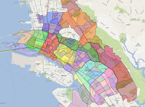
 neighborhoods + districtsOakland has many neighborhoods. Neighborhoods are usually nebulous or informal, and Oakland’s are no exception. Much depends on who is talking (lifelong resident vs. real estate agent, etc.), and when (old names fade, as new areas constantly regroup and rename themselves). Note also that neighborhoods may have been originally bounded by geographic features which are now hidden, such as undergrounded creeks, or split by more recent construction, like freeways. Regardless, it's rare that a neighborhood boundary is anywhere near as sharp as a line on a map, unless it is a major barrier like a freeway. Finally, in addition to the neighborhoods listed below, places are often labeled using larger, official city Planning Districts. (See also: Districts)
It is important to note that, historically, the definite article "the" never precedes the name of an Oakland neighborhood. This usage is common when referring to certain San Francisco neighborhoods ("the Mission" or "the Haight"), but is not a traditionally accepted way of referring to neighborhoods in Oakland. By this standard, it is incorrect to say "the Dimond," or "the Fruitvale." It is more common to hear people use "the" with districts, rather than neighborhoods, in which case the accepted usage would be "the Dimond District" or "the Fruitvale District." However, the non-standard usage seems to be increasing in recent years, especially by newcomers to Oakland. One sociolinguistic theory has it that this use of the article "the" is a marker of the gentrification of the neighborhood. One will hear "the Temescal" or "the Laurel," for example, but never "the Havenscourt" or "the Eastmont."1
Below is a breakdown of neighborhoods in Oakland, grouped by "District." This list is based on Greenstreets, the 1981 map that, for better or for worse, has become the de facto source for such information these days.2 Clicking your neighborhood (or any neighborhood) might lead to learning some cool stuff: historic places or businesses, local and hidden parks, and who knows what else! If you add a page, go ahead and tag it for your neighborhood- watch it show up the next time you visit! (Also, play along with the "neighborhood game!")
Another thought: Yelp and Craigslist divide Oakland into different neighborhoods/districts with different boundaries. How do these fit?
Urban Strategies recently made a map that overlays neighborhoods with census tracts. (Waiting for permission to post image here.)
The 1906 Husted's Business Directory, pages 16 and 17, lists a bunch of "Districts, Localities, Parks, Tracts, Etc." from Alden to Yoakum: https://archive.org/details/hustedsoaklandal1906oakl/page/16/mode/2up
Notes
1. One curious exception to this pattern is "the Twomps," a 1980's era name for the ungentrified-at-that-time neighborhood around 23rd Avenue in the San Antonio district of East Oakland.
2. That an obscure map about neighborhood tree planting has found itself as a widely-cited primary source in this internet age (including by Google Maps apparently!), is one of the many delicious ironies of the digital revolution.
List of neighborhoods
Source: OurOakland.net
According to this is a breakdown of Neighborhoods in Oakland, grouped by "District":
North Oakland
- Fairview Park
- Rockridge
- Bushrod
- Shafter
- Temescal
- Piedmont Avenue
- Golden Gate
- Paradise Park
- Gaskill
- Santa Fe
- Longfellow
- Mosswood
West Oakland
- Clawson
- Prescott
- South Prescott
- Hoover/Foster
- McClymonds
- Ralph Bunche
- Oak Center
- Acorn
- Acorn Industrial
Chinatown and Central
- Pill Hill
- Oakland Avenue-Harrison Street
- Glen Echo
- Adams Point
- Waverly
- San Pablo Gateway
- Downtown
- Lakeside
- Civic Center
- Old Oakland
- Chinatown
- Peralta/Laney
- Produce and Waterfront
Lower Hills
- Grand Lake
- Lakeshore
- Crocker Highlands
- Trestle Glen
- Glenview
- Upper Dimond
- Lincoln Highlands
- Redwood Heights
- Upper Laurel
San Antonio
- Lynn
- Tuxedo
- Reservoir Hill
- Cleveland Heights
- Bella Vista
- Highland Park
- Highland Terrace
- Meadow Brook
- Ivy Hill
- Clinton
- Rancho San Antonio
- Oak Tree
- Merritt
- East Peralta
Southeast Hills
- Woodminster
- Crestmont
- Skyline-Hillcrest Estates
- Caballo Hills
- Leona Heights
- Sequoyah
- Chabot Park
- Sheffield
Elmhurst
- Eastmont Hills
- Oak Knoll - Golf Links
- Toler Heights
- Foothill Square
- Castlemont
- Las Palmas
- Arroyo Viejo
- Webster
- Cox
- Iveywood
- Durant Manor
- East 14th Street Business
- Fitchburg
- Woodland
- Highland
- Elmhurst Park
- North Stonehurst
- Coliseum Industrial Complex
- South Stonehurst
- Brookfield Village
- Sobrante Park
- Columbia Gardens
Fruitvale
- Dimond
- Laurel
- School
- Upper Peralta Creek
- Bartlett
- Allendale
- Sausal Creek
- Patten
- Peralta Hacienda
- Harrington
- Jefferson
- Hawthorne
- Saint Elizabeth
- Fruitvale Station
- North Kennedy Tract
- South Kennedy Tract
Northwest Hills
- Panoramic Hill
- Claremont
- Hiller Highlands
- Glen Highlands
- Merriewood
- Forestland
- Montclair
- Shepherd Canyon
- Piedmont Pines
- Upper Rockridge
- Montclair Business
- Oakmore


